|
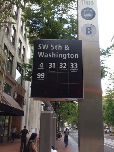
I snapped this picture of one of the new bus stop signs on the transit mall yesterday. It’s gorgeous, but I couldn’t help wondering where the stop id is? I’ve tried to use transit tracker a couple of times since buses came back to the mall and the first place I always look is on these signs – where it isn’t.
Now to be fair, the stop id IS on a map in frame display a few feet away. But why didn’t TriMet also put them in plain site on these signs?
As for the future, via Planetizen, here’s a concept from MIT for “bus stops of the future“. Maybe it’s not too late to order a few of these for the mall!
43 responses to “Bus Stops, Present and Future”
I just love how we have all this fancy stuff now,at the same time we are cutting services.
WHAT IS WRONG WITH THIS PICTURE?
What’s wrong with the picture is that the “fancy stuff” is already bought and paid for FTMP.
Chris: Now to be fair, the stop id IS on a map in frame display a few feet away. But why didn’t TriMet also put them in plain site on these signs?
Some of the signs have no room for any additional information. 5th & Pine, for example, has 13 routes and that area is packed. Others have 12 and are also full.
There is a certain minimalist aspect to the architecture which may explain why the number isn’t somewhere else on the sign — where would you place a 4- or 5-digit number, along with the information about what to do with the number?
Stop ID numbers can potentially change (although this is unlikely on the Mall), which is one reason they’re not permanently attached to a bus stop sign.
While I like the signage and the shelters (or at least what there is of them so far), why did they choose to paint the light poles, street lights, everything gray? I was hoping that this was just a primer. In a rainy city like Portland, gray is the wrong choice of color. It’s very depressing. I get the tie-in to the stainless steel look but it doesn’t work. Adding some vibrant colors would enhance the mall.
And if my sinuses weren’t exploding and destroying most of my brain, I would have remembered the simplest and most obvious answer to the lack of Stop ID numbers: each of these stops will have large digital displays with TransitTracker arrival information once construction is complete.
I went to the opening celebration and took home the Tri-met handout: “Downtown bus route and schedule changes”. This map gave me a bad taste of how the new system is set up.
First of all, I do not think it logical that the A,B,C,D stops on 5th Ave are labelled W,X,Y,Z on 6th Ave. I do not think it’s logical that the order is inconsistent — A,B,C,D translates into W,(Y,X),Z. I suggest Tri-met label the whole system be A,B,C,D on 5th and 6th.
Next, there are two sets of A,B,C,D stops on 5th and 6th. A 3rd set could be located in the PSU area but is left unlabelled as such, and has only the bus route numbers listed. Here, an A,B,C might be possible, but Tri-Met has set it up as a potential A,C,D. An A,B,C set in the PSU area would be consistent and logical.
C-Tran buses are arranged haphazardously. C-Tran routes 164 and 177 are grouped with Tri-met A,X, & D. C-Tran route 134 is grouped with Tri-met C, X, & Y.
Tri-met route 99 is grouped with stop X & B; route 19 is grouped with A & Z; route 8 is grouped with D & W. This ordering is not chronological nor alphabetical. It indicates that Tri-met is aiming to serve “one type” of rider – the one who gets off at stop (A), goes nowhere else downtown, and makes a return trip at stop (Z).
This is “Old School” transit planning philosophy. I’m a little disappointed that Tri-met has set the system up solely to serve rush hour commuters. Many people will find this system confusing, including probably most rush hour commuters.
The system rules out the use of color coding which certainly could help simplify things. I’m suggesting Tri-met drop the W,X,Y,Z designation in favor of A,B,C,D for both 5th and 6th. This would allow color-coding.
Aside from these basic complaints, the Tri-met handout was poorly arranged mass of gray ‘dot’ stations with no orientation for E/W and N/S signage.
When public complaints begin, these changes could be implemented fairly simply.
each of these stops will have large digital displays with TransitTracker arrival information once construction is complete.
I forgive you, then :-)
I can hardly wait!
Wells: Tri-met route 99 is grouped with stop X & B; route 19 is grouped with A & Z; route 8 is grouped with D & W. This ordering is not chronological nor alphabetical. It indicates that Tri-met is aiming to serve “one type” of rider – the one who gets off at stop (A), goes nowhere else downtown, and makes a return trip at stop (Z).
This is “Old School” transit planning philosophy. I’m a little disappointed that Tri-met has set the system up solely to serve rush hour commuters. Many people will find this system confusing, including probably most rush hour commuters.
“Old School” grouped routes at stops because of their destination (NE Portland, SW Portland, etc.), which were identified with sector symbols. This is how the original Mall was designed and remnants of it survived up to 2007. The new groupings are designed to balance the number of buses stopping at a given location; the old system tended (at different times of the day) to have a lot of buses stopping at one location and almost none at the next block.
The ABCD pattern may well have evolved as you suggested, except that the decision to combine the double-ended routes (9-Powell/9-Broadway) was made long after the plans to assign the letters on 5th & 6th (emulating the letters on 3rd & 4th).
my sinuses weren’t exploding and destroying most of my brain
Ouch!
balance the number of buses stopping at a given location
And that’s probably more important now with MAX trains, since if a bus has to wait to pull into its stop it will block a train (and other buses behind it), and since buses will only be able to leave their stops when a) the traffic signal is green b) there are no buses in the center lane and c) there is no train coming or passing.
Also, the A, B, C & D stops have no relation to the W, X, Y & Z stops. The problem is that a bus line may leave north with a group of buses (for example, the 19 leaves with the 12 and goes over the Burnside Bridge), but go with a totally different group of bus lines going south (the 19 follows not the 12, but the 9 and the 17 over the Ross Island Bridge).
As for C-TRAN, they were put wherever their bus volumes could be fit in.
Lastly, I understand that Denver uses the “X, Y, Z” system (and even guide signs that look just like the ones on 3rd & 4th) but uses the same letters on both the northbound and southbound streets.
I should add that these diagrams attempt to show how buses go different places to the north of the mall than to the south of it:
Portland Mall Service 1
Portland Mall service 2
3rd Ave bus distribution
Chris Smith wrote: Now to be fair, the stop id IS on a map in frame display a few feet away. But why didn’t TriMet also put them in plain site on these signs?
I’d like to know why at my stop (5th & Hall), there is one entire kiosk sign face dedicated to the rules of riding TriMet, while bus route and schedule information is reduced to the very, very bottom of the reverse signface (the one facing away from where passengers will board a bus) and is minimalistic — showing a very tiny map and the basic, approximate schedule information.
Anyone look at a new line 12 map now that TriMet combined the Barbur and Sandy segments into a single bus line? A 5 year old could draw a more useful map than what TriMet expects bus riders to use.
Meanwhile, over at the Portland Streetcar stop a couple blocks away – there is not only a very prominent Transit Tracker number, and a complete Streetcar schedule, but also a complete Streetcar map, AND a NextBus display. And no threatening signs telling you what is “prohibited conduct”.
Kind of strange that TriMet is more focused at the bus stop telling you what NOT to do, while on the Streetcar it’s telling you what you CAN do.
Fred just does it that way to make you turn green with envy, Erik.
They took the system maps out of the MAX cars. All the “ad” space seems to be on what the rules are, (in 2 languages, with info on complaining, in 10.) Clearly TriMet hates the MAX riders and wishes we’d all get confused and get off at the wrong stop or something. Meanwhile the bus has perfectly printed up schedules and info on the new transit mall even had people standing around telling people where their stop was last week. I think it is clear that TriMet just hates MAX riders and they clearly think we are a bunch of freeloading scufflaws. I mean, look at the new buses. TriMet got in new buses and they were out on the street in a week. TriMet gets new trains, and they drive them up and down the track with little signs in the window saying “Testing” just taunting us.
Anyone look at a new line 12 map now that TriMet combined the Barbur and Sandy segments into a single bus line?
Yes. Along with the new printed schedule, which is so large to the point it’s almost unusable.
“Old School” grouped routes at stops because of their destination (NE Portland, SW Portland, etc.), which were identified with sector symbols. […] The new groupings are designed to balance the number of buses stopping at a given location[…]
And, in my personal opinion, the new groupings are awful. It used to be if one’s destination was served by more than one route (or within walking distance of multiple routes) one could wait at a given bus stop, and ride the next arrival of any bus that serves a stop close to their destination.
Now, using service in downtown Portland practically requires comprehensive knowledge of the entire system, comprehensive knowledge of downtown, deciding which ONE route one wants to ride in advance, and until the Transit Tracker signs are posted one needs a cell phone or a printed schedule to try to guess when the next bus will show up. All of this makes the system much harder to use for an average individual.
there is one entire kiosk sign face dedicated to the rules of riding TriMet
If it makes you happy, the Manager of On-Street Customer Service says that those are to be covered with printed schedules soon.
Jason McHuff Says:
there is one entire kiosk sign face dedicated to the rules of riding TriMet
If it makes you happy, the Manager of On-Street Customer Service says that those are to be covered with printed schedules soon.
There will be single-timepoint schedules installed temporarily over that panel until construction is completed and the digital displays are in place.
Jason McHuff Says: Lastly, I understand that Denver uses the “X, Y, Z” system (and even guide signs that look just like the ones on 3rd & 4th) but uses the same letters on both the northbound and southbound streets.
Even after twenty-plus (thirty?) years of TriMet routing all the south-bound buses on the south-bound one-way street and north . . . I still have to direct people to Fifth Avenue if they’re headed into Southeast Portland — not tourists, but longtime residents and bus riders. The more I think about it, the more I think that using the same letters on both streets would be a recipe for confusion.
I do hope that the people complaining about stop spacing on the Mall aren’t the same people who regularly complain about downtown stop spacing for MAX. Too-frequent MAX stations slow the service down, which is in no way different than the buses running down the Mall.
Jason Barbour’s got a point. The old grouping system used to be very convenient if you were traveling to a location that was served by multiple bus lines. I generally commute by bike now, but when I did commute by bus I frequently took advantage of that fact.
Back in the day, I could catch a 32, 33, or 34 at the same stop, which would get me reasonably close to home. (The 34 was the best choice, but long ago, before MAX, it was converted to a “feeder” bus to the #33.) This appears to still be possible today for the 32/33/99.
But back then you could also get to Oregon City using any of those or the #35, but the #35 is at a different stop now than the 32/33/99.
Erik Halstead: I’d like to know why at my stop (5th & Hall), there is one entire kiosk sign face dedicated to the rules of riding TriMet, while bus route and schedule information is reduced to the very, very bottom of the reverse signface (the one facing away from where passengers will board a bus) and is minimalistic — showing a very tiny map and the basic, approximate schedule information.
The “Respect the Ride” panel is part of a current campaign and is included all over the system. By September, it will be considerably reduced on the kiosks, sharing space with schedule/route information.
All of the kiosks have a Mall map on the south side, so that with North up, the customer looks at it while facing North — which means the orientation is simpler to follow. Given that it’s a brand-new Mall and all of the stops have changed, it does seem a more helpful use of the space, especially given stops where as many as 13 routes serve the location. These maps will also change in September, with additional information given.
On 5th Avenue, the placement of the map actually means the customer is looking toward oncoming buses, incidentally.
I personally HATE that stupid ‘respect the ride’ campaign. Completely pointless, demeaning, patronizing and just plain CHEESY! I think most people are aware of the rules of common sense. Putting up ridiculous signs like that won’t enforce bad behavior; those types of people will misbehave regardless.
I kinda miss the old orange boxy ones that looked kinda creepy…
Oh, and PLEASE stop with the overuse of announcements in two languages, PLUS the bus driver’s own personal stop announcements. Very shrill over the intercom and annoying. And, again, patronizing. I would like a quiet ride, please.
I think that using the same letters on both streets would be a recipe for confusion.
And I’m not sure how well it works in Denver. Overall, the problem here is that a bus line could be grouped with many different other ones. For example, in North Portland the 35 goes near the 4 and the 44, but south of downtown, the 44 goes out Barbur, the 35 goes down Macadam and the 4 goes over the Hawthorne Bridge and out Division. Another problem is that Downtown Portland is so isolated from the rest of the city–Division is entirely disconnected from downtown, for example, and a person on 6th might not realize there’s more service on 5th.
Oh, and interesting idea of having all the maps on the south side.
True – we have the X, Y, Z system in Denver but it is not well marketed and not well understood by the average transit rider or perhaps even any transit rider but myself. Secondly, not every bus that stops at a Northbound X stop will also stop at a Southbound X stop… again, causing confusion at the “system”.
“Oh, and PLEASE stop with the overuse of announcements in two languages, PLUS the bus driver’s own personal stop announcements. Very shrill over the intercom and annoying. And, again, patronizing. I would like a quiet ride, please.”
Those with poor or no vision appreciate knowing when their stop is coming up. Also, it’s an ADA requirement to announce stops. Sorry that’s an inconvenience for you, but I find people’s cell phone conversations on the bus much more annoying than stop announcements.
If you dislike noise on the bus or train, an iPod works wonders. At any rate, I long to hear “mind the gap” in a British accent when I ride MAX. :)
Ryan Says: Oh, and PLEASE stop with the overuse of announcements in two languages, PLUS the bus driver’s own personal stop announcements. Very shrill over the intercom and annoying. And, again, patronizing. I would like a quiet ride, please.
The only announcements in two languages are the PSA’s, which are primarily fare zone announcements (although some of the “move to the back” announcements may still be circulating on buses — they should have disappeared as of May 24) or announcements about seating for elderly & disabled. These and stop announcements are mandated by the ADA. A lot of people find the operators’ personal announcements very helpful as they supplement automatic announcements or, in older buses, fulfill the ADA requirement.
As noted here, people with visual impairments find them helpful if not essential and people without such impairments can find them helpful as well, especially on a dark rainy night when it’s impossible to see anything through the windows.
It seems those suffering the most from the “balancing” of number of buses at each stop may be those in Southeast, which used to have a 4, 9, 10, and 14 (and 19?) at the same stop.(if my memory serves me). Now the 14 doesn’t even run on the mall!, the 4 is isolated from others, etc.
All this because the business community not only didn’t want MAX on 4th and on Broadway, but also demanded a continuous auto lane on the mall. Trimet acquiesced to this, and downplayed how much worse the mall would become for bus riders, with stops every 5 blocks instead of every 2 blocks.
I want to correct any impression I may have made that I’m unhappy with the new transit mall arrangement. For the record, there are many things I appreciate and admire about the new system. It’s just that I want it to work as flawlessly as possible.
It seems to me that the A,B,C,D and W,X,Y,Z designation is confusing and more complicated than it should be. Designating both 5th and 6th stops A,B,C,D seems simpler.
I picked up another Tri-met handout Wednesday, the Tri-met System Map effective May 24th. This map appears better than the other handout map mentioned in my original post. It still uses ‘dots’ rather than ‘rectangles’ which I believe differentiates E/W from N/S lines downtown better.
I particularly like the “Bus mall groupings” window which shows that 5th and 6th groupings are close enough to ‘identical’ that the A,B,C,D designation could probably be used for both transit mall streets.
For example: 5th Ave Stop ‘A’ routes are 9,17,19. However, 6th Ave Stop ‘W’ routes are 9,17,8. Route 19 is grouped with ‘Z’. Why couldn’t route 19 be grouped with ‘W’ and route 8 grouped with ‘D’. It’s a simple swap.
Stay with me: The 5th Ave Stop ‘D’ routes are 1,12,94,8. The 6th Ave Stop ‘Z’ routes are 1,12,94,19. In other words, Stops A,D,W,Z could easily be made identical. And the only difference between routes B,C,X,Y is route 99. They too could easily be made identical, easily.
As for differentiating northbound from southbound bus lines, simply orient to Willamette. Complicating the northbound routes by designating them W,X,Y,Z is like those day/night watches that alternately display a sun or moon to indicate daytime and nighttime.
I’ve looked at the notion of creating an A,B,C Stop setting in the PSU area. I’m pretty sure it’s possible. Stops X & C are routes 35,36,44,54,56,(99). These routes enter and exit downtown on Columbia/Jefferson, north of PSU. If Stops X & C were designated ‘D’ on both 5th and 6th, an A,B,C Stop designation could be put together in the PSU area.
Like I said, Tri-met is trying to serve the bus commuter who gets off at one stop, works in some office counting beans on that block, and wants a return ride home from a bus stop on the same block. That system doesn’t serve most bus and MAX riders. It’s flawed because it makes the system more complex for most riders. I don’t like it. I’m probably not the only one who senses something wrong with the system. I’m probably one of the few who’ve figured out this shortcoming.
Otherwise, Kudos Tri-met. Righteous job, dudes!
Here’s an idea that would allow A,B,C,D Stop designations for 5th and 6th that would work for my example of the commuter who wants their bus stops on the same block:
Make 5th Ave Stops — A,B,C,D
Make 6th Ave Stops — D,C,B,A
This would make the Alphabetical Stops on the same block. What could be simpler?
I repeat another suggestion: Swap Stop ‘D’ bus routes 35,36,44,54,56,(99) with Stop ‘C’ bus routes. This would allow the continuation of an A,B,C Stop arrangement near PSU.
There appears to be a contradiction between the two maps! The “Downtown bus route and schedule changes map” shows bus routes 35,36,44,54,56 have stops on 5th and 6th between Columbia and Clay. The “Portland system map” (which is better) shows bus routes 35,36,44,54,56 turning onto the transit mall at Columbia and Jefferson. In other words, they don’t have a stop on 5th and 6th between Columbia and Clay.
Which is correct?
Wells: There appears to be a contradiction between the two maps! The “Downtown bus route and schedule changes map” shows bus routes 35,36,44,54,56 have stops on 5th and 6th between Columbia and Clay. The “Portland system map” (which is better) shows bus routes 35,36,44,54,56 turning onto the transit mall at Columbia and Jefferson. In other words, they don’t have a stop on 5th and 6th between Columbia and Clay.
What is the “Portland system map”?
Those routes travel into/off the Mall on Harrison.
Ooops. Jeff is right. Sorry. Bus routes 35,36,44,54,56 turn onto/from the transit mall at Harrison, north of the PSU area.
I meant the bus routes 4,31,32,33,(99) at Stops “B” and ‘Y’ that cross the Hawthorne bridge. If those Stops were both designated as “D”, then an A,B,C Stop arrangement could be made in the PSU area. The PSU stops are also almost identical to the other Stops.
Of the 17 bus routes in the A,B,C,D grouping, only 3 bus routes(19,8,99)are out of order. In the PSU area, of the A,B,C Stop grouping near PSU, only 1 Tri-met bus route(43)and the C-tran bus routes are out of order. An A,B,C Stop grouping near PSU is possible.
The “Portland System Map” effective May 24th is available at Tri-met’s Pioneer Courthouse Square office. It does not show the MAX Greenline Transit Mall Stations.
Wells wrote: Bus routes 35,36,44,54,56 turn onto/from the transit mall at Harrison, north of the PSU area.
And watching this turn in action, this is becoming a major problem — buses are getting stuck in this intersection and backing up.
Meanwhile, northbound, I’ve seen at least one 12 bus almost miss the stop at Hall (the same stop that has been there for several years) and have to cut across two lanes of traffic to make the stop. Then buses are forced to cut back across several lanes of traffic to make the left turn onto Harrison.
Of course this could be resolved by putting down a dedicated, marked bus lane, and improving the 4th & Hall stop to match the Mall and Harrison stops.
(BTW, EngineerScotty, that was a great comment you posted June 2, 2009 8:10 PM. But I see here that once again the rules are selectively enforced so that open attacks on those who Bob and Chris disagree with are fully permitted.)
Well… when you engage in arguments like “rail facility X is nicer than bus facility Y, therefore Tri-Met must hate busses”, and repeat the same thing over and over again, a little mockery is in order. An earlier, somewhat harsher comment of mine along the same lines was excised by the mods, I should note.
At any rate, the transit mall serves MAX, and numerous bus lines; it would be impractical to list routes and schedules for each, whereas streetcar stops only have one route to document.
Personally, I kinda like the subterranian transit tunnel (serving bus and rail) up in Seattle; which doesn’t have the same constraints that a street-level transit mall has to operate under. But we’ve been digging our subways for sh*t rather than for transit; I doubt the $$$ needed to construct such a thing will be forthcoming.
So, during today’s major downpour during evening rush hour, did TriMet distribute umbrellas (as indicated in a previous press release) to all the transit riders waiting without shelters on the mall? Sorry, couldn’t resist.
In other shelter-related news, I’ve noticed that at a few locations, the number of riders waiting in a shelter area exceeds that which would be covered by the roof area of the shelter.
The problem is that while there are many more bus lines serving a particular block, there is actually less overall shelter area per block than there used to be.
I hope that in the long run, TriMet will consider restoring the same amount of shelter, per anticipated waiting rider at a given time, as we used to enjoy on the mall.
I hope that in the long run, TriMet will consider restoring the same amount of shelter, per anticipated waiting rider at a given time, as we used to enjoy on the mall.
I rather wish they’d done that in the first place. Of course, any shelters at all would have been nice today, giving us riders an alternative to crowding into the doorways of businesses.
Construction on Mall bus shelters is finally underway as the new metal rafters are being delivered. I have photos from this morning of shelters in various states of completion, including one actually being worked on.
Thanks for the update and the photos, Jeff.
I have photos from this morning of shelters
If your camera’s time is correct, I just missed you by about 7 minutes. I took a little detour over to the Davis St. stop to get a picture to show especially the narrow walkway that the construction has created there. But even without it, people boarding the bus means that there’s basically no through pedestrian zone, which the mall project supposedly wasn’t supposed to affect.
Also, I think that is about the only stop with a printed schedule posted. Which brings up the question, wouldn’t a schedule still be useful even with Transit Tracker? Say, for somebody who is planning a later trip?
Jason McHuff Says: If your camera’s time is correct, I just missed you by about 7 minutes. I took a little detour over to the Davis St. stop to get a picture to show especially the narrow walkway that the construction has created there. But even without it, people boarding the bus means that there’s basically no through pedestrian zone, which the mall project supposedly wasn’t supposed to affect.
Yes, well, that was because it was supposed to be finished prior to returning the buses. Things have changed. Mitigating the disruption is currently a major focus.
Also, I think that is about the only stop with a printed schedule posted. Which brings up the question, wouldn’t a schedule still be useful even with Transit Tracker? Say, for somebody who is planning a later trip?
Lacking infinite resources, TriMet customer information is based on a simple concept that there are three basic travel phases and that the desired information differs from phase to phase. Trip-planning is the first phase, and the effort has focused on providing that information through a number of devices, including printed schedules. By the time customers get to the stop, most are focused on a single question: “When will my bus arrive?” So, yes, one could make an argument about posting printed schedules (which can be awkward to keep current) but it would be at the expense of something else and be of value to a fairly small number of customers.
I still can’t believe that TriMet placed absolutely no wind protection into the shelter design. Between that and the strange stop placement choices, I think that TriMet absolutely missed a big opportunity: rather than getting a world-class transit presence downtown, we’ve been “value engineered” into wandering about looking for our stop and then waiting in the rain.
The last time I saw proposed designs for the new shelters (back when I was advocating for preservation of the old shelters, before they were used for simulated terrorist drills and subsequently melted down for $750), there were to be freestanding, positionable (by engineers, not freely moving) U-shaped glass wind screens. The idea was that they could be positioned relative to the predominating breeze at various stops. Whether those made it through to final design, I don’t know.
Last night, I saw the shelter illumination operating. (Not sure when this was enabled, but I hadn’t noticed it before.)
For those who haven’t seen it, the large vertical support columns feature a metal mesh surface texture, which is illuminated internally from ground to roof-line, giving a lantern-like glow to the shelter.
As people know, I have a number of practical criticisms regarding the new shelters, but I must say that somebody seriously deserves a design award for this lighting idea.
Question: Is it just one support per shelter that is illuminated (which appeared to be the case with the shelters I saw last night), or will all the supports get this treatment? It looked a bit odd to have only one illuminated column in the larger shelters which have multiple supports.
So, after complimenting an aspect of the new shelters, I can’t resist a snark about this afternoon’s change in the weather: How did the distribution of the free umbrellas (a promise from a previous press release) go today? Were they well-received? :-)