Last Thursday, the steering committee overseeing the Lake Oswego transit alternatives analysis got an update on the evaluation of alternatives. I’ll hit the highlights below, but the full presentation is here (PDF, 3M). There are also some visual simulations that I will post later when I receive them.
To get involved in the process, you can attend two open houses next week, and a formal public hearing on July 16th. Details are on our calendar.
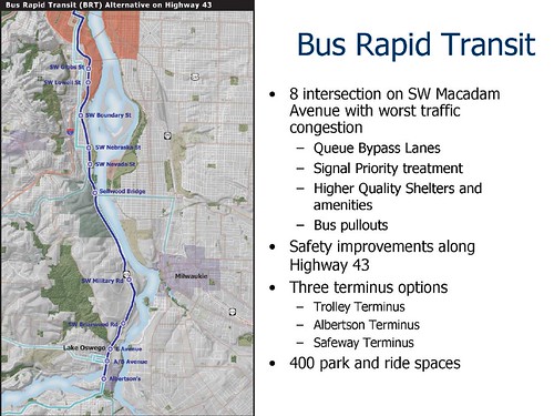
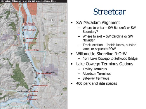
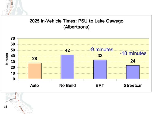
The first interesting piece of data in the evaluation is that Streetcar has the best travel times among the alternatives due to the availability of dedicated right-of-way. Even with queue-jump lanes at intersections, BRT gets stuck in congestion on Highway 43. In fact, Streetcar travel times are better than auto travel times, even with the more conservative total travel time measure (versus in-vehicle time). This is one of the few corridors in the region where transit beats autos on total time. There is an interesting question the steering committee will need to grapple with that doesn’t appear on the slide. If the alternative chosen is to run in Macadam through Johns Landing – avoiding the political challenge of running next to the existing condos and likely contribution to a higher development potential – the price is several minutes in travel time. 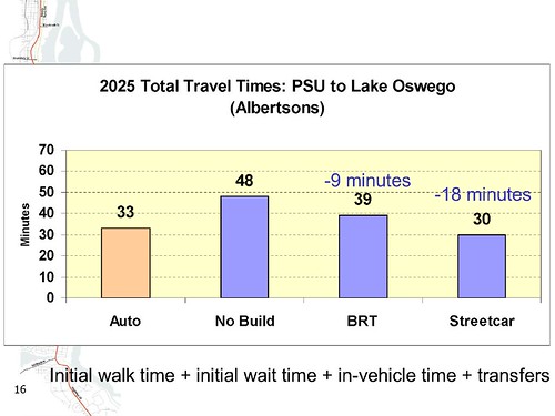
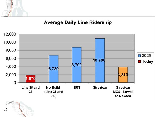
Streetcar also appears to have the highest potential ridership. 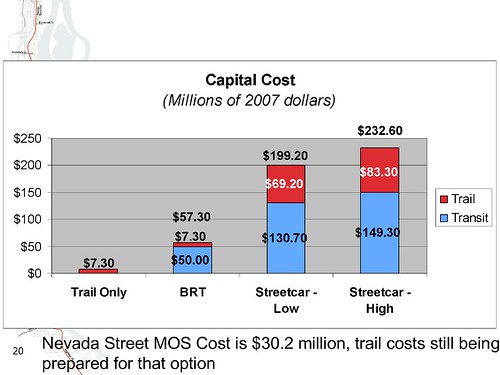
There is a very unfortunate conflict developing between Streetcar and a trail in the same corridor. The critical pinch point is the tunnel through Elk Rock, which is not wide enough to accomodate the Streetcar and the trail (it’s barely wide enough for one Streetcar track). Since there is no practical way to run the trail over or around Elk Rock, a poor set of choices are left:
Yuck all around. 
While Streetcar has higher initial capital costs, lower operating costs make it less expensive than BRT over a 20 year horizon. 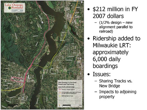
One of the questions the Metro Council posed is whether it would be more effective to reach Lake Oswego via an extension to the Milwaukie LRT line. A very preliminary analysis suggests that capital costs would be higher and ridership would be lower. However, operating a DMU-type commuter rail service on the existing rail bridge may have some potential. |
62 responses to “Lake Oswego Transit Update”
With regards towards the BRT operating cost, what type of vehicle is specified for it?
What is the breakout between a “clean diesel” bus and a hybrid diesel-electric bus, that has 20-30% better fuel economy?
As for the Elk Rock Tunnel, I’d hardly state that it isn’t sufficient for Streetcar; in fact it was designed for freight trains and the Red Electric interurbans (which were significantly larger than a Streetcar or MAX). The only “problem” is that the interior of the tunnel is not concrete-lined (it’s exposed rock) but that could be rectified quickly if desired.
I wouldn’t dare suggest a trail be put through the tunnel either; originally the railroad line went around Elk Rock so why couldn’t the trail simply go around it too? If nothing else, it’d make for a rare “scenic viewpoint” with nothing else around you – no homes, no trolleys, no streets.
If the bus would still be stuck in traffic, why is it called Bus Rapid Transit? Is it any different than an Express Bus? What happened to BRT having dedicated ROW?
I think having a Streetcar stop at either end of the tunnel is a fun solution, as long as you can keep people out of the tunnel! Hikers and bikers can take a break, eat a sandwich, hop on the Streetcar, and be on their way.
Now, I just rode the streetcar for the first time between the tram at OHSU to River Place. The operation down by Moody is really like a Toonerville trolley. The single tracking and curvatures of the rails is what I would expect to see in trolley museums. This must be even worse then I remember in the Boyleston St. subway in Boston, which was built in 1897. The Skoda cars crawled around the curves like a single truck Birney car.
No wonder I am so underwhelmed by the rail operations here in Portland. Why don’t you go all the way–sell the Skodas and buy Birneys from Gomaco. They would be more fitting to the trolley operation here.
Studies and projected travel times notwithstanding, I think we could expect more of the same if this line is ever extended to LO.
The “BRT” proposal sounds more like what LTD in Eugene is calling “Bus Plus” — a bus with some BRT characteristics (queue jumping, signal pre-emption, limited stops) but without its own right of way. If it costs more over the long term than streetcar while providing slower service, I don’t see much advantage to it.
I couldn’t tell from the document — was there a comparison of capital and operating costs between a Macadam alignment and keeping the train on the existing right-of-way? From the map, we’re looking at moving the route one to two blocks west to slow down the trip and create traffic conflicts. I’m just guessing both capital and operating costs will be higher as well.
Why not just use the existing ROW for a faster trip, especially if it costs less? Is any streetcar rider really going to be put off by walking an extra two blocks to the nearest stop? If the study is concerned about development options along Macadam, I seriously doubt a potential streetcar rider will be dissuaded from having to walk another 200-300 feet to catch the streetcar.
Unlike the “local circulator” streetcar projects we’re seen so far, the Willamette Shore Line would be a true commuter project, designed to move people between Portland and Lake Oswego. Speed matters a lot more here than it did in Northwest Portland, the Pearl District, South Waterfront, or even the eastside loop. Especially if there’s the prospect of offering a faster trip than potential riders could make in a car.
The “trail issue” doesn’t seem like much of a sticking point, since the “key findings” noted that a “continuous trail may not be possible, even if local streets are used to bridge gap.” I’m not very familiar with the geography of the area near the tunnel, but if we can’t carve a trail through Peter Kerr Park, why not take the trail uphill to a wide sidewalk on the east side of Macadam and back down again after the tunnel? Maybe run a trail along the edge of Elk Rock Garden?
If pedestrians and bicyclists need to take the streetcar through the tunnel, just make sure the riverfront trail crosses — or terminates at — the proposed Riverwood and Briarwood stations, and create a “fareless” zone between those stations. That’s the least “yucky” option I can think of.
I’d like to point out an important factor about the ROW… A main reason that BRT is not being evaluated on the existing ROW is because of special legal considerations:
The streetcar ROW is not actually publicly owned. On many of the properties, the original railroad negotiated “railroad easements”… the ground below is still owned by the surrounding property owners, and if an operating railroad ceases to use the easement, the ROW eventually reverts back to the property owners. Thus, we can’t just pave it over and run buses.
If we do use significant portions of the existing ROW, we can use the estimated value of that ROW as the “local match” for federal funds, which is why the streetcar mode performs so well financially in the above comparisons.
But a huge problem with chunks of the existing ROW is that it is very, very narrow, with residential structures sometimes built right up to the tracks. Now, I think the residential property owners bear some responsibility for this (you shouldn’t build right next to existing, maintained tracks and expect that regularly scheduled train service will never run again in the future), but the fact of the matter is that there isn’t much room for things like stations, passing sidings, pedestrian access, etc.
While it is true that the existing ROW allows for a faster end-to-end travel time, it may not allow for very frequent service… If it comes down to a question of trading 3 minutes of travel times for 5 minutes shorter waiting times for departures (not actual figures), there may still be an overall time and service benefit to moving portions of the alignment.
– Bob R.
“I think having a Streetcar stop at either end of the tunnel is a fun solution, as long as you can keep people out of the tunnel! Hikers and bikers can take a break, eat a sandwich, hop on the Streetcar, and be on their way.”
But bike commuters wouldn’t want to hassle with this. I like Erik’s suggestion of building around the trail around the rock.
Regarding the tunnel and pedestrian/bike access, a number of ideas have been discussed.
It should be noted (although I’m not very familiar with the statutes involved) that there are legal requirements that usually require transportation projects of this nature provide a pedestrian trail nearby. To omit the pedestrian access element would mean seeking some kind of variance/waiver, and would of course not fly well with a number of constituencies. Also, as mentioned above there are ownership issues with the ROW, and it may not be possible to NOT have rail service and still have pedestrian access.
With the tunnel, the main problem is that federal regulations preclude pedestrian walkways within a tunnel unless there is a 2-hour (IIRC) firewall… basically meaning you need a separate tunnel.
The cliff faces are too unstable to connect a cliff-attached pedestrian walkway. A floating “esplanade” might work but access ramps would have to spiral and would be expensive, and there is much evidence that falling rocks (those unstable cliff faces again) could routinely strike the area below.
A spiraling walkway up to Hwy 43 would be very tall and very expensive, and it is unclear if there would be anywhere for the pedestrians to walk along the highway in that stretch.
Personally I’m in favor of the compromise where minimal streetcar platforms (no need for shelters or other amenities, really) are placed at either end of the tunnel, along with signage/schedules, and bikes/peds simply board/deboard at either end. The only problem with that is after streetcar operating hours, the trail becomes impassable, but many trails are closed at night anyway.
I share djk’s idea of a very short “fareless tunnel” zone and I mentioned the idea at the last Streetcar CAC meeting.
If I remember the location right, the tunnel goes through Peter Kerr Park (Google Map). The tunnel makes an S-curve, meaning daylight is not visible from either end. You can see from the map how steep the cliffs are and how little shoreline is present.
– Bob R.
Answering a number of questions:
– I am told that three rail lines have ‘fallen off’ the outside of Elk Rock. Apparently there are lots of rock slides. Hanging the rails or the trail off the rock has been judged non-viable.
– The tunnel is 17 feet wide at its narrowest point. That is just barely wide enough to operate a single track.
– BRT is being designed with queue-jump lanes at key intersections because it is simply uneconomical to widen 43.
– There are significant grade changes between the Willamette Shoreline alignment and 43 near Elk Rock. It’s not really viable to get up, over or around the Rock with a trail.
– The choice between Macadam and the existing alignment through Johns Landing will come down to balancing three factors: development potential (fair number of parking lots that could sprout buildings), travel time and the political resistance of the condo owners to having a Streetcar go by their windows only 10 feet away.
Many riders would have to transfer in LO, adding to their trip times. Also, because the streetcar runs west of the office district, many riders might transfer at PSU to get to work, instead of walking an extra 4 or 5 blocks, again adding to travel times. Right now, the #35 bus runs right down 3rd and 4th Avenues.
Single track operation under real world conditions would result in one car having to wait for another to exit–just like I saw down by OHSU, again adding to travel times.
Thus, the comparsion between streecar and BRT begins to look a lot less favorable.
But I guess that this makes no difference, since the steering committee is probably stacked with rail people anyway.
Nick wrote: No wonder I am so underwhelmed by the rail operations here in Portland. Why don’t you go all the way–sell the Skodas and buy Birneys from Gomaco. They would be more fitting to the trolley operation here.
Let me see if I understand you correctly: You believe the streetcar route segment you rode along (Gibbs to Riverplace) was too slow due to jogs/turns in the trackway.
Your suggestion therefore is to replace the modern streetcars with replica Birney trolleys which A) are 1/3 smaller than the current, full-to-capacity streetcars, B) are not articulated, C) have fewer boarding doors, D) take longer for ADA boardings (high floors), and E) have a lower top operating speed. Is that right? How will that possibly improve things.
The jog that the streetcar track takes along Moody Ave. allows it to get into its own dedicated ROW, where it can (and does) travel at top speed down to the Gibbs terminus.
The jog could have been avoided by running in-street all the way to Gibbs, but this would have been A) more expensive (requiring double-tracks to match traffic directions), and B) a slower way to operate at peak periods when there is mixed traffic.
I realize you may have meant your “go all the way” suggestion in jest, because there is no practical advantage whatsoever to be gained from doing that: Lower capacity, slower boardings, slower travel speed.
– Bob R.
But I guess that this makes no difference, since the steering committee is probably stacked with rail people anyway.
Those grapes are probably sour, too.
– Bob R.
development potential (fair number of parking lots that could sprout buildings), travel time and the political resistance of the condo owners to having a Streetcar go by their windows only 10 feet away.
Travel time and development potential I can see. We also should consider capital and operating costs. But why is that last one even a factor? People bought condos right next to an existing and quite visible rail line, and we’re worried that we might offend some of them by running rail traffic on it?
But I see a fair compromise here. If there’s putting the streetcar on Macadam will incur significantly higher costs, pass the hat. If developers on Macadam and condo owners along the rail line can collectively put in enough money to make up the difference, fine … do it that way. Otherwise, go for speed and cost savings.
Which brings me back to my earlier question: is there any estimate as to the differences in cost between a Macadam alignment and the railroad ROW?
Many riders would have to transfer in LO, adding to their trip times. Also, because the streetcar runs west of the office district, many riders might transfer at PSU to get to work, instead of walking an extra 4 or 5 blocks, again adding to travel times. Right now, the #35 bus runs right down 3rd and 4th Avenues.
An important question is what bus service would remain along Highway 43 if a streetcar is implemented… there are still a few places on Hwy 43 which are not easily reachable from the streetcar ROW. Would something like the #35 keep operating (and therefore provide one-seat rides for Oregon City / West Linn riders).
Based on FY2006 boarding counts (before mall reconstruction), approximately 350 daily northbound boardings (1/3 of northbound rides) get on between Oregon City and Lake Oswego, but do not get off. (Depending on where you draw the line.) I didn’t analyse the #36 because the overall boardings across the entire line are very low.
Even if we assume that a streetcar would completely replace the #35/#36 service for the corridor, if the streetcar ridership projects are correct (and historically for the Portland Streetcar, ridership has exceeded projections), then only about 6-7% of the overall riders will be transferees from the old #35/#36 service.
Question: Should we avoid doing something that increases ridership in the corridor by a factor of 5x to 6x if 7% of those riders will be inconvenienced?
Regarding 3rd/4th avenues, the historical route for the #35 is on the mall, 5th/6th avenues. It has only been relocated due to reconstruction and should return to 5th/6th two years from now. According to the counts, most of the incoming ridership deboards between Naito and Taylor. The #1 inbound destination is 5th and Main.
Those popular destinations will be served by a light rail train every 5-7 minutes and numerous buses as well, meaning that transfer waiting times (should someone elect not to walk) will be a 2-3 minutes at most during peak hours.
For those who do have destinations on 3rd/4th and choose to walk, there are two lovely car-free pedestrian plazas (on what used to be 2nd and 3rd through the auditorium district) with fountains, restaurants and convenience stores, which allow a pleasant, non-stop walk through the equivalent of 3 city blocks.
– Bob R.
“To get involved in the process, you can attend two open houses next week”
I’m pretty sure the open houses are yesterday and today, unless there is another event I am unaware of.
“I realize you may have meant your “go all the way” suggestion in jest, because there is no practical advantage whatsoever to be gained from doing that: Lower capacity, slower boardings, slower travel speed.”
>>>> Bob:
I was just being a little sarcastic, relating the amateurish design and clunky operation of the Portland Streetcar to what I have seen elsewhere in my lifetime.
However, Pittburgh Railways did operate prewar center-entrance, low floor streetcars at one time (over 1000!) Maybe if we had had something like this, albeit modified, in Portland, we could have charged people to ride, instead of giving everything away–which is the reason why you have 10,000 boardings a day, costing the city $2 million a year to subsidize.
See, despite all the hype, Portland was not the first in the country to have low floor cars–they’ve been around since WW1.
Calling bus service than primarily runs in traffic a BRT is a gross misuse of the language; almost as bad as calling Portland’s modest Bikeways “Bike Boulevards.” The key to meaningful BRT is dedicated ROW; then we can compare. This decision looks to be Streetcar, hands down.
“Those grapes are probably sour, too.”
>>>> See the Portland Tribune 9/20/06. I guess the mayor of West Linn had sour grapes, too, when West Linn was left out of the streetcar talks. I wonder why–perhaps a little degradation of service to WL with a streetcar in operation?
This is one process that looks like it was definitely stacked. Is it not disgusting for a region that boasts of being so progressive is replete with deals and cronyism?
Maybe if we had had something like this, albeit modified, in Portland, we could have charged people to ride, instead of giving everything away–which is the reason why you have 10,000 boardings a day, costing the city $2 million a year to subsidize.
Nick, the streetcar segment you rode this morning lies mostly outside of fareless square, I trust that you had a valid fare instrument.
43% of the streetcar stops (counting the Lowell extension opening this summer) are completely outside fareless square.
Those stops within Fareless Square are no more of a “giveaway” than any other transit vehicle operating in the same area.
The future of Fareless Square will be decided by an upcoming public process, probably next year, so I hope you’ll show up and make your feelings known. (I for one support the idea of retaining fareless square, but reducing it in scope and increasing security measures.)
– Bob R.
I once visited someone in those apts./condos as a trolley raced thru 10′ away and it was quite dis-
concerting. Do we know what the insurance liability
would be? Running over Fluffy w/a streetcar
is bad for biz…
which is the reason why you have 10,000 boardings a day, costing the city $2 million a year to subsidize.
Going by your stated figures, that’s a subsidy of well under 60 cents per boarding ride, which is less than the subsidy for most bus routes.
– Bob R.
I once visited someone in those apts./condos as a trolley raced thru 10′ away and it was quite dis- concerting. Do we know what the insurance liability would be? Running over Fluffy w/a streetcar is bad for biz…
Given that the streetcar runs almost (but not quite) entirely in shared right-of-way with cars, and is not known for leaping out of the trackway to attack Fluffy’s pals, I imagine the liability is similar to operating a bus.
– Bob R.
I agree with Nick about the Portland streetcars not being very modern. I suggest we go with Teleportation. Just like in the Stargate show, drive the loaded streetcar into a portal at Riverplace and come out instantly at OHSU. Of course, everyone is converted into gays at OHSU, but the SoWa district is looking pretty sterile so far anyway. On the return trip to Riverplace, they get reverted back to heteros unless they’re homosexual already, in which case the conversion process is the reverse. Run a separate train through the teleportation gate from Riverplace to Lake Oswego, in which case, passengers emerge there as hoity-toity’s and go looking for a clothing store to buy something more appropriate to wear. :-)
Interestingly, the chart showing the streetcar plus trail seems to put the extra width needed on trail’s bill rather than streetcar’s.
Shouldn’t that chart start with the low cost of the trail as red, and the extra cost as streetcar’s? Or at least split the costs?
And travel times and cost per rider on the trail aren’t in the charts. If we’re talking 5-7 miles, a cyclist can do that in about 30 minutes.
“The only problem with that is after streetcar operating hours, the trail becomes impassable, but many trails are closed at night anyway.”
It is kind of different. The trails that I use to get home on my bike after MAX shuts down are “closed” but there is a nice well worn path around the gates, and what I’ve heard is that, unless you are drunk/high/don’t have lights, if the police catch you, they just tell you you shouldn’t be there, and that is that… I imagine that the tunnel will have cameras on it, so you will probably get caught, and probably get accused of terrorism of something… Could they “signal” it, (I’m thinking the “signals” they have on the draw bridges in town where a giant gate blocks the path from entering the tunnel,) so that when there was no train coming through it that you could ride/walk through it? I imagine the 2 hour fire rule only applies if you don’t have time separation on the users, which you would…
FYI, according to the PortlandTransport Calendar, there is an Open House tonight at 6pm:
LOPAC Open House
When: Wed Jun 27 6pm – Wed Jun 27 8pm
Where: US Bank Building, 120 N State St, Lake Oswego, Oregon
Description: Lake Oswego to Portland Transit Analysis
– Bob R.
I’d love to take the Streetcar to LO.
So with as realistic a guess as possible… …how long is this process gonna take?
When is the ETA for the east side to get built?
To Nick’s critique of service to South Waterfront, perhaps he noticed a large barge plant where the return track should be? Mr. Zidell gets to set the timeline for when we’re no longer single track there :-)
I guess it’s a question of looking at the glass as half empty or half full. I look at it has 10,000 daily riders full.
So with as realistic a guess as possible… …how long is this [Lake Oswego] process gonna take?
When is the ETA for the east side to get built?
I don’t have a good answer for LO, we won’t have a Locally Preferred Alternative until the fall, and there’s no funding strategy yet. I think we’re still talking years.
The eastside is considerably brighter. Best case would be to begin construction in 2008 and maybe open in 2010 or 11. That requires some cooperation from the Executive Branch, but it’s not impossible.
The streetcar ROW is not actually publicly owned. On many of the properties, the original railroad negotiated “railroad easements”… the ground below is still owned by the surrounding property owners, and if an operating railroad ceases to use the easement, the ROW eventually reverts back to the property owners. Thus, we can’t just pave it over and run buses.
Actually it is – as long as the right-of-way is still used as a railroad in some sense. (That’s why the Willamette Shores Trolley exists, to maintain the rail operation. That’s also why a consortium of governments – Metro, Clackamas County, Lake Oswego and Portland, and TriMet all own the line; that’s why you’ll find TriMet “NO TRESPASSING” signs on all trestles and at the tunnel; that’s why TriMet actually cobbles up money each year to fix something (usually a bridge).
But it is correct, if the trains stop moving, the land grant expires and it reverts to the adjoining property owners. This dates from the old railroad land grants of the 1800s; this line was originally built in the 1870s as a narrow-gauge railroad that at one time extended as far west as Sheridan and Dallas, and south to Springfield.
but the fact of the matter is that there isn’t much room for things like stations, passing sidings, pedestrian access, etc.
Well, there is room for a “bus stop” (read: a small concrete pad and a sign) at some places, but that wouldn’t be right, degrading rail transit to that of a lowly bus.
Given the traffic volumes at some locations, that’s really all that would be needed. And even the existing Willamette Shores Trolley has several designated stops that are nothing more than red “Trolley Stops Here” signs.
that there are legal requirements that usually require transportation projects of this nature provide a pedestrian trail nearby.
Say WHAT?!!! What is the law, and why would it be required?
If there is a law, than we’re already in violation; Washington County Commuter Rail has no such path; the existing Portland Streetcar has no such path (from Riverplace to Gibbs); MAX has no such path…
I am told that three rail lines have ‘fallen off’ the outside of Elk Rock. Apparently there are lots of rock slides. Hanging the rails or the trail off the rock has been judged non-viable.
In all of the history books I have read that cover this route, I have never heard of such an incident. Yes, falling rock was a problem and that was the reason for building the tunnel (plus the trestle was sharp, and trains had to traverse it slowly.
The falling rock could easily be mitigated with current technology (blasting loose rock, nets). If a trail couldn’t be built there, someone better tell ODOT that building a trail on segments of the Historic Columbia River Highway can’t be done either.
As to the tunnel being 17′ wide – the Streetcar only requires a right-of-way of what, ten feet? I’m at a loss as to why a seven foot margin is unacceptable.
Should we avoid doing something that increases ridership in the corridor by a factor of 5x to 6x if 7% of those riders will be inconvenienced?
I find that to be more evidence that the Streetcar/Light Rail crowd continues the policy of disinvestment and/or elimination of bus service.
As someone alluded to earlier, if a trail and rail operation shared the tunnel, there would need to be 2-hour firewall between them. 17 feet would not allow that.
There is no legal requirement to do a trail alongside the transit project, but the Alternatives Analysis process was chartered to provide recommendations on BOTH a trail and transit alternative. Delivering only one will be a political disappointment at the very least. We need to keep our think caps on for this one.
If there is a law, than we’re already in violation; Washington County Commuter Rail has no such path; the existing Portland Streetcar has no such path (from Riverplace to Gibbs); MAX has no such path…
Too bad there isn’t a law like that. I’ve always been disappointed that Westside MAX didn’t come with a parallel multi-use path from Beaverton to Hillsboro. It would have been so easy…
Chris wrote: There is no legal requirement to do a trail alongside the transit project
I stand corrected… I misheard somebody during the casual discussion after the last CAC meeting.
Erik wrote: As to the tunnel being 17′ wide – the Streetcar only requires a right-of-way of what, ten feet? I’m at a loss as to why a seven foot margin is unacceptable.
The streetcar doesn’t require 17′ of width, but most tunnels are not perfectly rectangular… as the height of the tunnel increases, the available width decreases. Although the tunnel itself may be 17′ wide, it is not at its full height across the entire width. Presumably the streetcar will be centered through much of the tunnel, leaving only 3-4 feet on either side (with lower ceilings too), not nearly enough for a safe regular-use trail.
I find that to be more evidence that the Streetcar/Light Rail crowd continues the policy of disinvestment and/or elimination of bus service.
So should I take your answer to the question to be a “No”? You would not prefer to see a project that can increase corridor ridership by 5X to 6X because 7% of the riders may be inconvenienced?
(And the inconvenience would only be that of having to transfer… the travel time estimates show that even with transfer waiting time included, travel times will improve for West Linn riders.)
It seems you would rather pave over trackway to allow bus service while still maintaining a weekend tourist service. Wouldn’t this cost more than just having upgraded streetcar service?
– Bob R.
Given the value of the ROW as local match for an even larger chunk of federal dough, running Streetcar in the old ROW is about as close to a no-brainer as things can get. And it gets all around better numbers.
Detouring to Macadam degrades the product with not much return; better to offer buy outs to condo owners who are anxious and create some affordable housing in Johns Landing.
Timeline?…if LO can get Dunthorpe on board, get out of the way.
Trails are a “cut and paste” affair, done in segments as money is found. I’m not sure but what double tracking isn’t more important. We need to do what’s doable, but not let the tail wag the dog.
better to offer buy outs to condo owners who are anxious and create some affordable housing in Johns Landing.
Why buy out anyone? People who don’t want to live next to a streetcar line can sell their condos to people who actually want the stations close by. If the experience of the rest of Portland over the past couple of decades is any indication, rail transit will increase the value of those properties anyway.
djk –
When I rode the Willamette Shore Trolley along the line, it seemed to me that a number of condo units had their bedroom/patio doors within just a few feet of the tracks, closer than most Pearl District units ever get to the streetcar. (I’m not sure what the wisdom was behind building the units so close…)
However, looking from the air using Google Maps, it may only be a handful of units that are this close, due to the diagonal orientation of the buildings, so it may not be as big of an issue as I first thought.
Regarding the use of Macadam vs. the original ROW through Johns Landing, I still think there is an opportunity for a split alignment… run one direction on the original ROW, and run another direction in the median of Macadam. There is room for this and it will remove many conflicts with traffic.
Along most of the split, the distance between the two trackways would be no greater than the distance between Lovejoy and Northrup where the streetcar runs today.
Alternately, if the median proves unsuitable, run just one shared-lane track on Macadam for use in the off-peak direction. For example, assuming that inbound commute times are slightly more important than outbound commutes, run streetcars southbound on the original ROW (so as to avoid conflicts with southbound auto traffic), and northbound in the mixed Macadam ROW.
Either option could save costs over double-tracking Macadam, and would achieve at least some of the access benefits of having tracks further westbound than the current ROW.
– Bob R.
If the experience of the rest of Portland over the past couple of decades is any indication, rail transit will increase the value of those properties anyway.
I’m not sure that is true. Its proximity to a station, not the line itself that raises values. I think you will find places along the MAX track out in Washington County where MAX lowers the adjacent property values because there is no real access to a nearby station.
My understanding is that a couple of things happened when those condos were built that were unfortunate:
1) The developers told the prospective buyers the rail line was going away. Obviously that didn’t happen. Indeed the government consortium that bought it for $2M now has an asset that may be worth up to $50M.
2) Easements or other waivers were granted to allow the buildings to be very close to the rails and/or allow parking near the rails.
The sins of the past…
Its proximity to a station, not the line itself that raises values.
Oh, no question there. But every condo with the streetcar line next to it would be within six blocks of a station, with no arterial crossings. Add a station at Pendleton (if there’s room for a station; there might not be) or move the Nebraska station north to Carolina, and the walk drops to three or four blocks. I don’t know how far away a unit needs to be from a rail station before the station stops adding value, but I’m guessing it’s more than four or five blocks.
Interesting that the ‘Forgotten Bridge’ over the Willamette between LO and Milwaukie is formally being considered again for ‘regional rail’ service, running vehicles like those on the Beaverton-Wilsonville line. If I had to chose which rail project to support, between the SoWa streetcar or the regional rail to Milwaukie, I’d chose, wait for it, both!
Last time I was on the LO Trolley, it seemed like at least one property too close to the line could be ideal for a streetcar station if the land were rezoned as commercial, and the properties operated restaurants serving trolley-goers, were it not for the privacy concerns of the American culture. “Who are you? What do you want? Get off my property! ra-ra-ra-ra!”
It seems you would rather pave over trackway to allow bus service while still maintaining a weekend tourist service. Wouldn’t this cost more than just having upgraded streetcar service?
No.
I don’t support (there’s no reason to) pave over the WST; and besides as I already pointed out, even proposing such would be grounds for the adjoining property owners to claim title to the land.
What I am – and have been – opposed to, is using rail-based transit to degrade bus service. There’s no reason to reduce 35-Macadam service, given that it serves many stops that would not be served by the Streetcar extension; unless comparable substitute service can be maintained along Macadam/Riverside between Lake Oswego and the Sellwood Bridge.
Interesting that the ‘Forgotten Bridge’ over the Willamette between LO and Milwaukie is formally being considered again for ‘regional rail’ service, running vehicles like those on the Beaverton-Wilsonville line.
I’ve considered this for a very long time, especially since it would connect downtown Sherwood, Tualatin, Lake Grove, Lake Oswego, and Milwaukie – along with numerous bus lines (12/94 in Sherwood, 76/96 in Tualatin, plus proximity to Lake Oswego and Milwaukie transit centers, potential Streetcar and MAX lines).
Given that this railroad route carries far less freight traffic than the Beaverton-Wilsonville line (about one-two trains a day between Lake Grove and Milwaukie, one round-trip a day maximum between Lake Grove and Sherwood which occurs at late night hours), I could see this line being operated with equipment such as Bombardier’s Talent DMU that is more “compatible” with MAX (in terms of design, both are low floor vehicles and have a similar appearance) that wouldn’t have to meet the crashworthiness requirements as freight operations already occur outside daytime hours.
especially since it would connect downtown Sherwood, Tualatin, Lake Grove, Lake Oswego, and Milwaukie
I thought there was a proposal in the South Corridor discussions that would have had the trains run from Beaverton and connect in Tigard through Lake Oswego to Milwaukie. It may have required new connecting track in Tigard, I don’t remember the details. But the idea was a direct connection from Milwaukie to the MAX in Beaverton.
What I am – and have been – opposed to, is using rail-based transit to degrade bus service. There’s no reason to reduce 35-Macadam service, given that it serves many stops that would not be served by the Streetcar extension; unless comparable substitute service can be maintained along Macadam/Riverside between Lake Oswego and the Sellwood Bridge.
In case you didn’t notice, I wasn’t arguing in favor of removing the 35 (in fact, I made several of the same arguments in favor of the 35 as you did), but rather calculating how many people would potentially be inconvenienced if the 35 were in fact reduced/eliminated, and even then it’s a maximum of 6-7% of projected riders.
And (this bears repeating), the overall trip times from West Linn, including transfer waiting times, are projected to be shorter, so “degrade” is in the eye of the beholder. Unlike you, I don’t view rail and bus as competing modes, but rather as complementary modes.
– Bob R.
What I am – and have been – opposed to, is using rail-based transit to degrade bus service. There’s no reason to reduce 35-Macadam service, given that it serves many stops that would not be served by the Streetcar extension; unless comparable substitute service can be maintained along Macadam/Riverside between Lake Oswego and the Sellwood Bridge.
Erik, what you’re missing is that as Highway 43 congests over the next 20 years, the 35 is going to slow to a crawl. That’s the ‘no build’ scenario in the presentation.
Several people have brought this up:
An important question is what bus service would remain along Highway 43 if a streetcar is implemented… there are still a few places on Hwy 43 which are not easily reachable from the streetcar ROW.
According to TriMet’s most recent TIP (FY 2007), on pg. 40 of the printed version or PDF pg. 51:
If the streetcar is selected as the primary transit mode in this corridor, TriMet would consider terminating the Line 35 at Lake Oswego, relying on the streetcar to provide service between Lake Oswego and downtown Portland.
Since there are some prelim plans to extend MAX to SOWA already, would it be more appropriate to run larger MAX trains down this heavy rail line to LO from the South Waterfront and onto the Transit Mall?
I am not promoting one idea over another, but there is a decided lack of big-picture planning with rail lines in Portland, considering how close in proximity and timelines MAX/streetcar/rail lines are being planned.
What type of capacity and speed tradeoffs would there be between MAX and streetcar?
Also, is it possible to put in additional portions of double-tracking? What about turning over half of Macadam Ave thru Johns Landing as 2-way tracks on one half of the street (and restripe the other half as 2-lanes for cars?)?
Interesting that the ‘Forgotten Bridge’ over the Willamette between LO and Milwaukie is formally being considered again for ‘regional rail’ service, running vehicles like those on the Beaverton-Wilsonville line. If I had to chose which rail project to support, between the SoWa streetcar or the regional rail to Milwaukie, I’d chose, wait for it, both!
I’d like to see a heavy rail connection from the new Commuter Rail to run from the Beaverton TC down 217, over I-5 and connect to Lake Oswego and the new Milwaukie MAX line. The connecting segment (tunnel or elevated?) could fit in a short segment parallel to Kruse Way with a stop to bring one of the biggest office corridors access to high-capacity transit.
Google Maps:
http://tinyurl.com/3xyxzk
Ross Williams Says:
especially since it would connect downtown Sherwood, Tualatin, Lake Grove, Lake Oswego, and Milwaukie
I thought there was a proposal in the South Corridor discussions that would have had the trains run from Beaverton and connect in Tigard through Lake Oswego to Milwaukie. It may have required new connecting track in Tigard, I don’t remember the details. But the idea was a direct connection from Milwaukie to the MAX in Beaverton.
That would have been me.
For some clarification and expansion on this idea… see this map I put together of all of the proposed rail routes in the south corridor(s):
http://img223.imageshack.us/img223/9997/southmetrohg2.jpg
You can download the google maps path for this proposed transit line:
http://web.pdx.edu/~jusw/img/fantasyloop.kmz
Oops, I guess the Yellow Line is already in use for Interstate MAX! You get the idea, though.
I’m assuming half the streetcars would turn back at Lowell in the South Waterfront and the other half would continue on to LO?
Its truely absurd how close some properties were built to the tracks, one such apartment complex was built with absolutely no regard to the rail line and managed to build the parking lot with the rail line running diagonally through.
The idea behind the streetcar vehicle over MAX on this line is that the streetcar vehicle is more suited to the nature of the line: the route doesnt need the high capacity of MAX and streetcars are much lighter weight and are more intimate for its setting.
Bob R, I really disagree on having the streetcar cut over to Macadam. Many of the alternative options for the line diverting over to Macadam require several slow sharp 90 degree turns much like the ones Nick mentions above with the track under the Marquam or by PSU. In my opinion more in-street trackage particular away from the city center is not what this transit route needs especially when an off street right-of-way exists. Having the streetcar run high speed then shift to a slow in street operation then back to a high speed operation really makes no sense and will increase the travel times and reliability. New condos are being built closer to the track(but not on top of it). Plus the right of way is only a block or two from Macadam.
I think its key to start focusing on speeding up the operations of transit in Portland. As someone who rides the streetcar many times daily, I feel we need to avoid building anymore slow in street traffic operations as much as possible. Just look how much traffic backs up and delays the streetcar on Lovejoy in the afternoons or anytime around Burnside & 10th/11th.
Putting a trail through the tunnel (even if it could be done with fire codes) would create a pretty sketchy area for pedestrians even with lights (it has a curve in it too so its not flooded by natural light like a straight tunnel). I think its best to keep a tunnel of this length off limits to pedestrians. Sure people will go in the tunnel as they do now but if there is a path through it they can legally be in the tunnel and I think its best not to have it be alright for people to hang around deep inside a tunnel which is already in a rather low visability area (the streets are a pretty good distance from the tunnel portals).
Renderings of the streetcar along this corridor available here…
http://www.metro-region.org/article.cfm?ArticleID=20869
J –
Just to be clear, what I’m proposing is a compromise… currently forecasts seem to predict more development and higher ridership if the streetcar runs on Macadam through Johns Landing. To the extent that is true and/or desirable as part of the overall picture, I’m saying that we could run one direction only on Macadam (using the median rather than mixing with traffic, which will improve travel times over an all-Macadam route), and run the other direction on the existing ROW.
This also has the advantage of being an extensively double-tracked route while only having to built one in-street track, and avoiding the pinch points in the original ROW while still being able to fully utilize that ROW.
– Bob R.
zilfondel writes:
What type of capacity and speed tradeoffs would there be between MAX and streetcar?
Also, is it possible to put in additional portions of double-tracking? What about turning over half of Macadam Ave thru Johns Landing as 2-way tracks on one half of the street (and restripe the other half as 2-lanes for cars?)?
Before that, Chris wrote:
Erik, what you’re missing is that as Highway 43 congests over the next 20 years, the 35 is going to slow to a crawl. That’s the ‘no build’ scenario in the presentation.
So, do we want Highway 43 to be congested in 20 years (without expanding the highway), or do we want Highway 43 to be congested in 10 years by artficially constraining supply, and then following the example of Westside MAX by realizing that the demands on roadways won’t decline, thus forcing an expensive highway reconstruction through either a heavily developed area (SoWa, Johns Landing) or a geographically challenging area (Sellwood Bridge-Lake Oswego)?
Using the WST corridor provides a Streetcar (or MAX) alignment without interfering with Highway 43/Macadam Avenue and is a wise use of public dollars (given the millions paid to buy the line). Failure to use the WST line will result in that investment being totally sunk, as the landowners will have the legal right (not privilege) to claim the land and without any payment required.
Likewise, rail-based transit (and especially Streetcar, which is designed for local circulator, not point-to-point transit) will at best slow, but certainly not stop the inevitable traffic volume count on Highway 43. Is it prudent to artificially contribute to it, or is there a plan for a new highway bridge linking A Avenue (in Lake Oswego) or Terwilliger Blvd. east across the Willamette River to Highway 99E in Milwaukie?
I don’t see what the fuss is about a “single track pinch” point, when Streetcar today has two such “pinch points” – on Montgomery Street (which was an absolutely dumb design but the Streetcar fans seem to like it) and from River Parkway to Gibbs (including the insane S-curve underneath the Marquam Bridge). Why is it OK up north but not south?
Erik wrote:
“I don’t see what the fuss is about a “single track pinch” point, when Streetcar today has two such “pinch points” – on Montgomery Street (which was an absolutely dumb design but the Streetcar fans seem to like it) and from River Parkway to Gibbs (including the insane S-curve underneath the Marquam Bridge).”
>>>> Toonerville Trolley operation, I dare say.
I don’t see what the fuss is about a “single track pinch” point, when Streetcar today has two such “pinch points” – on Montgomery Street (which was an absolutely dumb design but the Streetcar fans seem to like it)
Actually, Erik, if you had been paying attention, there aren’t any streetcar fans who “seem to like” the current, temporary single-track alignment at 4th and Montgomery.
Just a few weeks ago, the Portland Streetcar CAC passed a resolution recommending to the developers of the Block 153 parcel its suggestions for the future alignment through the middle of that property.
Regardless of which future configuration is chosen (the developer’s proposal or the CAC recommendation) there will be a dual-track alignment through that area.
This has actually been discussed here on PortlandTransport.
Once again you’ve put made-up opinions into the fictional minds of made-up streetcar supporters. When will it end?
– Bob R.
Toonerville Trolley operation, I dare say.
Yep, you sure do, and words to that effect: often.
– Bob R.
“Once again you’ve put made-up opinions into the fictional minds of made-up streetcar supporters. When will it end?”
I don’t know, but I see a forthcoming tv pilot with smoke filled rooms at Metro and a dark Goldschmit character lurking in the shadows.
As a designated member of a fictional group that I didn’t even know existed, I want to know where all the secret meetings are. I mean, if there’s a plot to destroy the bus system and keep the suburban commuter down, I want to join in ;)
As a designated member of a fictional group that I didn’t even know existed, I want to know where all the secret meetings are. I mean, if there’s a plot to destroy the bus system and keep the suburban commuter down, I want to join in ;)
Well you just designated yourself, and confirmed it by declaring your opinion that bus service should be eliminated. I guess that my opinion is not only not fictional, but has been proven as a fact.
Actually, Erik, if you had been paying attention, there aren’t any streetcar fans who “seem to like” the current, temporary single-track alignment at 4th and Montgomery.
Then why was it built? If it’s “temporary” why was it built to “permanent” standards? What will it cost to remove it, and who is going to bear the cost?
(My guess is that Streetcar riders aren’t, it’ll be a line item in TriMet’s operating budget which means that I’ll get stuck with the bill and the money will likely come from the bus operations & maintenance budget, since Fred Hansen dare wouldn’t take a pay cut or cut his office’s budget, retire his personal fleet vehicle or eliminate TriMet’s SOV business fleet, or cut MAX/Streetcar programs.)
Then why was it built?
It was built because there was a building in the way at the time, but multiple parties were interested in future redevelopment of that block, and planning was done for a future diagonal alignment through the block. Thanks for asking.
If it’s “temporary” why was it built to “permanent” standards?
We’re talking less than 300ft of trackway here, Erik… the rest was the preexisting original terminus.
The developer’s proposal is to continue to use that track for one direction of travel, and install one additional track diagonally through the block. The CAC’s recommendation is to run two diagonal tracks.
– Bob R.
I guess that my opinion is not only not fictional, but has been proven as a fact.
1. If the proposed route ever took full sized rail vehicles then there will be ample room for the Streetcar or Max vehicles.
2. Oregon is a State – what does any Federal requirement have to do with having a foot path/bike track adjacent to a streetcar line through a tunnel? Feds simply have no jurisdiction. The route is not an Interstate Railroad is it? Note that all rail tunnels have footpaths for the use of the rail workers. No need for any fire wall – in any case, the streetcars are not powered by gas or diesel, so no fuel to create the fire.
3. A stop at each end of the tunnel and a ‘fare free zone’ for passengers, including bikes, through the tunnel is the sensible and cheap idea. If there is a demand for use of the trail after services have ceased, then let pedestrians/cyclists through after hours. No need to light the tunnel, cyclists have lights on their bikes, pedestrians can carry torches. And if they are worried about gang loitering in the tunnel, they should either not be out at night or walk/cycle the long way round or take a taxi.
4. If you have a good asset and there is a good idea to use it for the common good, go for it!
—Just had my attention drawn to this discussion, hence the gap between previous and my comments!
One down; three to go.
A 24 minute PSU to LO streetcar trip is now officially out. Metro’s packet for the project’s CAC meeting next week has the time between Bancroft and the LO downtown Albertsons at 18 to 22 minutes. Add at least 13 minutes for PSU to Bancroft (the current 12 to the Lowell stop + 1 minute for the new alignment and stop on Moody north of the aerial tram) and we’re looking at 31 to 35 minutes. This is on the optimistic side of plausibility, but far more realistic than the Alternatives Analysis’ original 24 minute projection. (The times are not final, and we won’t really know the trip time until it starts running in a few years.)
In some ways, the damage probably has already been done. There’s no way of knowing if any individuals on any of the boards, committees, councils, or commissions who voted to eliminate other alternatives partially on the basis of the earlier projection might have voted otherwise with a more realistic streetcar trip time.
You forgot to mention that the #35 covers the LO-to-downtown trip in ~30 minutes during rush hour, ~20 minutes off-peak, at least according to the timetable.
The line is being marketed as “rapid streetcar”, but 22 minutes to go about six miles doesn’t strike me as rapid. Since it will be a continuation of the existing 23rd Avenue line, the service will be limited to one-car consists–so volume won’t be much better than a bus either. (If it were going down the Mall and thus capable of 2 or 3 car trains, that might be a different matter).
If there isn’t a service improvement of some sort, I’m not sure what the point is. TOD doesn’t strike me as a good answer for this particular corridor, as the entire length of the line is either a) unsuitable for development due to geography, b) owned by Very Rich People, who aren’t likely to sell at any price that would attract developers even in a boom market, or c) is already developed. There aren’t any greenfields or brownfields along the route, other than possibly near SoWa, service to which doesn’t require an extension to LO.
IF the thing really has to be built, has anyone considered the option of keeping the #35 as is, but running only half the Streetcars past SoWA–possibly timing the service to meet up with the #78 (which requires a transfer already)? That way, LO residents who won’t ride the bus can ride the streetcar, West Linn residents won’t have their commute ruined, and the operational expenses probably are a wash? Either that, or make #35 a local north of LO and reduce the number of streetcar stops?
In an age of extreme obesity, a rails-to-trails project is desperately needed.