In the last few days we’ve heard quite a bit about TriMet’s failures during the 12/18-19 insta- winter storm. The Max breakdowns were one thing, but there were also a number of complaints about misleading internet tracking information ( “there was no notice of anything out of the ordinary with her route….She waited and waited at the stop, but even though multiple buses came in the other direction, no bus ever arrived. She had to walk home”) or just no information posted at all. In light of that, thought I would write a quick note about train/bus info promulgation as I saw it in Japan.
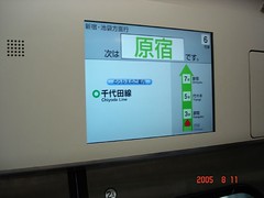
Rail real time arrival display – © 2005 Rick Browning – all rights reservered. |
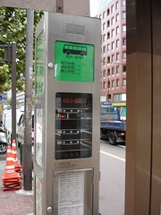
Real time arrival for multiple bus lines – © 2005 Rick Browning – all rights reservered. |
In the last few days we’ve heard quite a bit about TriMet’s failures during the 12/18-19 insta- winter storm. The Max breakdowns were one thing, but there were also a number of complaints about misleading internet tracking information ( “there was no notice of anything out of the ordinary with her route….She waited and waited at the stop, but even though multiple buses came in the other direction, no bus ever arrived. She had to walk home”) or just no information posted at all. In light of that, thought I would write a quick note about train/bus info promulgation as I saw it in Japan.
One of these days soon I really will start to unleash the vast trove of photos and observations from my 7 weeks in over there this summer/fall.
One series of photos and notes has to do with bus/train signage. It is dynamic and accurate, and no – you don’t log on w/yr computer at home. It is right there. Where you are standing and waiting. At the bus stop or the train station – telling you w/text and graphic icon displays exactly how many minutes for the next bus or train. If you are already on the bus or train – it is telling you while you sit in your seat how many minutes to the next stop, how many stops to the end of the line, what order they are in, the amount of time between every stop (real time, not schedule time), what doors to use to get on and off… and once in awhile – an advertisement with women in bikinis… (OK, just faithfully reporting my observations, not endorsing, but it does command at least male attention a little more than icons of train cars – video advertising also provides revenue to the transit agency; is there something wrong with this?).
I attach a few photos. One shows a video screen aboard a train similar to Max (not long distance). The second shows a bus stop with multiple line dynamic electrionic kiosk. These are not displaying static schedule info, but actual real time, variable conditions. My message – if they can do it, we can too. We in the USA are like in the transit stone age, even in Portland. But we don’t have to be. I hear TriMet is working on it.
Let’s all wish them luck.
11 responses to “Real Time Transit Info in Japan”
Real time info–without a computer or cell phone– would be great. I wonder if they have this in the neighborhoods too, and not just in the downtown areas?
pcc
See, this coudn’t work here because we can’t read Japanese.
A question for Chris –
Given your relationship to Portland Streetcar, how familiar are you with the NextBus system? How does it compare to the system that TriMet uses?
I like that Nextbus can show you a real-time map with moving vehicles. Presumably, given this much GPS data, in times of massive disruption or delay, NextBus could (in theory) tell you _where_ the bus you are waiting for is currently, even if it can’t reliably tell you _when_ it will reach you. Even this small additional amount of information is very helpful compared to no information.
NextBus does not appear to have picked up very many customers over the years, and I see they were acquired by another company. Are there going to be future enhancements to existing customers, or will they have to shift to a new system?
(And, if shifting to a new system is in the cards for Portland Streetcar, would it make sense to integrate into the TriMet system?)
My same points apply to the TriMet system as well: If you can’t say “when”, at least say “where”.
For example, on Monday afternoon I decided to take MAX into downtown from NE 60th. Through much of the day, due to ice, TriMet had been turning trains around at Gateway.
However, I had arrived at the station (it was later revealed) at precisely the time when trains were no longer turning back at Gateway. This meant that all eastbound trains continued on toward Gresham, and there were no trains coming from Gateway for awhile.
After 30 minutes of waiting (with no information telling us how long we’d have to wait, or if a train was coming at all), I was actually considering giving a complete stranger a carpool lift (I live nearby and transit commuting is optional for me), a train finally arrived.
If the real-time display had simply shown “Closest inbound Blue Line train is currently at E. 148th Ave”, everyone at the station could have observed the train’s gradual process instead of standing around wondering if they should go home, take a cab, find a bus, etc.
– Bob R.
Responding to a couple of queries on this post:
1) TriMet is not expanding their real-time displays at stops except where they have network connectivity (they have fiber along the Max lines). One of my dreams for Portland Transport is to put a series of kiosk displays in coffee shops and other places near popular bus stops. Anyone want to help?
2) Streetcar adopted NextBus because at the time TriMet’s system was still in the planning stages. Having worked with both now, I like TriMet’s approach and I can tell you that there are efforts underway to integrate NextBus’ data into the TriMet display system.
I also want to note that TriMet has been following the discussion here about Next Arrivals info during the storm, and Fred Hansen has communicated to me that they are making this a priority. But I can also say that having seen their traceback of the specific situations some folks mentioned here, giving meaningful predictions under those circumstances will be a challenge.
I think men would still watch the Japanese bikini women though.
Seriously, though, after Portland goes wireless, I’d probably be willing to drop $25 on a little pager thingy that lets me enter in a stop ID and get a readout on the next bus/train from anywhere in the city.
Oh, fine, I know–I’m supposed to get a web cell phone instead…I just don’t want anything so fancy.
Kiosks would help too.
Chris –
When Trimet decribed this system during its planning stages it was described as a real time system using GPS. I know that they changed that for the MAX line, but have they abandoned that concept altogether. I don’t see why storms would have a huge effect on a system based on actual bus locations.
There must be more to the system or was this just a projection of what they wanted to do and then they settled for something less?
Ross, TriMet’s GPS system is excellent, and they know the precise position of each vehicle, including MAX.
The challenge is in making predictions. If a bus h asn’t moved for 15 minutes because it’s stuck in the snow, how do you predict when it will arrive two miles down the line?
I have made the suggestion that in storms, they ‘gracefully’ degrade to just tell people the location of the vehicles and let riders make their own conclusions. I suspect riders checking status regularly may be able to draw better conclusions than a software algorithm.
TriMet’s current policy is to shut the system down when the predictions become unreliable. I agree that it is better to display no information than misleading information, but would still prefer partial information, if it’s appropriately labeled.
Chris –
I used to be in the display system and character generator business… even contacted NextBus at one point about a project that didn’t get off the ground (years ago…)
It would seem to me that an economical information display device could be outfitted to transit stops as long as there was:
1. Power
2. Semi-reliable free access to nearby Wireless (Portland Telco Project?)
At minimum, you’d need an inexpensive microcontroller with a lightweight operating system and onboard wireless networking, a character display (LED or flipdot), and a weatherproof housing.
You could get creative and add software voice synthesis, a speaker, and a button so that the visually impaired could press a button and receive the latest update. The system would otherwise be silent, so as not to disturb passers-by or neighbors.
– Bob R.
Bob, I was thinking about recycled PCs, ala Free Geek, running Linux driving flat panel displays.
Weatherization and reliability would be the greatest concern, regardless of platform.
You might be able to find out-of-date (but entirely useful) industrial controllers, which are basically just PCs with touch-screen displays in a rugged housing.
Another idea would be to locate the screens in nearby transit-friendly businesses, like coffee shops. Then, weatherization and vandalproofing don’t matter.
– Bob R.