|
More ideas for alternatives for the Columbia River Crossing:
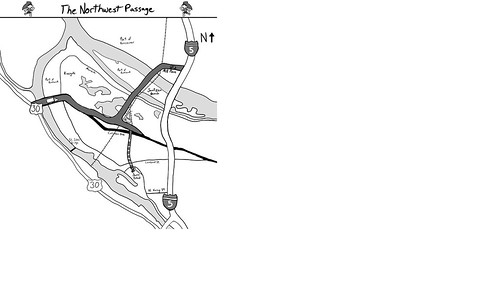
The Third Bridge Corridor
Focus is on the economy, safety, and the environment.Approximately:
- 7 miles long
- 3 bridges
- 1 tunnel
- 1 viaduct
Estimated Cost:
$350-370 Million$3.5B to $3.7BHave an entire list of financing ideas.
Definitely green, including the color.
Location:
The northern end connects to the I-5 Freeway at Mill Plain in Vancouver Washington . As a viaduct adjacent to Mill Plain Extension’s alignment a 6- lane freeway turning west toward the Port of Vancouver. The new freeway then parallels the Transcontinental Rail Line know as the “Center of the project area” and the “Heart of the I-5 Corridor.” Provide access to the Port of Vancouver, waterfront area, Hayden Island, Marine Dr., Columbia Corridor, Lombard, across to Highway 30 west of Linton at Newberry Hill and 124th. A tunnel to Swan Island creates access to downtown Portland and a second access off the Swan Island. Local access is provided between Vancouver, Hayden Island, the North Peninsula, and Highway 30.
Multi-Modal Capacity:
Entirely multi-modal 6-general purpose lane freeway includes a Land Bridge with bicycle and pedestrian access the entire 7 miles. Possibly the first in the nation to have bike, ped access between our ports and industrial area, from our downtown’s and residential areas including the 40 mile loop. The addition of transit services, and new heavy speed rail bridge with tunnel to Swan Island, and Rose Quarter.
Overview:
The Third Bridge Corridor is an alternative that adds multi-modal capacity across the rivers, and connecting I-5 Freeway with direct freeway access to the ports and industrials. The ports and industrials areas will be on one continuous corridor with direct freeway access to I-5 Freeway, HWY-30, and Swan Island.
Safety and Health:
Removes freight and overflow traffic from neighborhood streets adjacent to I-5 Freeway, ports, and industrial in both states. More bridges provides more route for safety between our two states, for Hayden Island, and Vancouver. The bridge over the Willamette into the Rivergate area will reduce freight and regional traffic off the Historic St. Johns’ Bridge and town center. Viaduct in Vancouver removes surfaces level port and industrial traffic off of neighborhood streets with grade separate freeway.
Green Construction:
Construction without interruption to I-5 freeway, or current roadways cost less and is environmental friendly. As bare vacant publicly owned land construction can start immediately. 24-Hour a day construction inside industrial area.
The bridges on this alignment are already in the adopted Oregon Regional Transportation Plan of 2000.Economy:
The Third Bridge Corridor will provide jobs now, and needed infrastructure for jobs in the future. This new freeway infrastructure will bring density in the industrial attracting business.
Relieves Congestion:
Removes traffic from the I-5 freeway, I-205, I-84, I-405, and HWY-26. Less traffic going thorough center of Portland Construction causes no congestion. Creates new parks and viewing areas. Addresses safety issues, cleaner air, helping the economy, environment, and adding a new freeway that will not increase urbane sprawl. Direct access to our ports and industrial areas from residential areas, downtown Vancouver, and Portland.
42 responses to “Third Bridge One-pager”
$350-370 million is a BIT low. Still this would be far cheaper than the combined CRC and Freeway Loop projects, especially when you add in a number of proposed MAX lines that could be served by bus instead.
yeah, i can’t imagine how even this supposed tunnel would cost under $350m. Also not sure how the excited parts of Vancouver would be for that gigantic “viaduct” running through their city. Still, it’s an interesting idea, and I like how it explicitly connects all of the industrial sites; i am concerned about how much “local” traffic would start using this bridge and bring cars through the already busy streets of North Portland.
Ron, if “a bit low” means you shifted the decimal point to the left about two points, I will agree with you.
Jim
would this bridge have MAX across it or not?
Ron, if “a bit low” means you shifted the decimal point to the left about two points, I will agree with you.
Jim
Agreed. I didn’t write that. However, fabrication of the bridges could likely be done on land, as the Fremont was. I don’t agree with the viaduct concept, either. Downtown Vancouver residents would be throwing things at us across the water for decades.
Removes traffic from the I-5 freeway, I-205, I-84, I-405, and HWY-26.
How would this effect I-205 or I-84 at all? Is the idea that people currently take I-84 east to take I-205 north instead of I-5 currently?
Great concept, though it would never work.
1st, it is much longer then the current I-5 route so it would not make an effective bypass. (Current I-5 commuters and freight would have to travel west on US30, then back track east on the new alignment).
2nd, there is only one freeway-to-freeway connection. The US 30 end dumps traffic onto a city street that is already maxed out with freight traffic.
3rd, it ignores the real problem, which is I-5 within Portland city limits. That stretch was designed for 1960’s traffic and hasn’t been upgraded since. None of the lane widths, # of lanes, overpasses, ramp lengths, shoulder widths, or sight distances come close to meeting FHA codes.
4th, it relies on a “green” element to gain support from liberal Portlanders. They admit it would be the first bike trail between industrial ports in the nation, all while not realizing that the reason for this is that there is little to no demand for bike trails between industrial ports.
The only real way to “fix” I-5 is to fix I-5. I’m no traffic engineer, but its obvious that the only real fix of I-5 would be its complete reconstruction, from the twilliger curves to the state line.
Revise the 6-lane freeway to a 4-lane arterial to reflect the actual demand (as Anthony points out, it’s not a freeway bypass because there’s no loop on the west side), kill the $10B tunnel portion, and this project has some merit.
Add upgrades to the BNSF bridge, light rail, and a local Hayden Island bridge (closing some or all I-5 ramps to the island), and it’s a project.
Of course, the price tag ends up in the same ballpark ($2.5B?), but it solves more problems than the current CRC proposal. We could manage I-5 congesion for free with congestion pricing, if we wanted.
As for Vancouver/Clark residents throwing a fit over added traffic through their community, that comment is too ironic to bear.
“As for Vancouver/Clark residents throwing a fit over added traffic through their community, that comment is too ironic to bear.”
I don’t think that is fair. Vancouver has the same problems created by traffic from Clark County auto-dependent development that Portland does.
Deliberately dumping a bunch of traffic off SR500/SR14/I5 headed to Portland through Vancouver is not a good solution. I don’t think that is necessary, but an arterial bridge needs to be designed to discourage use as a bridge bypass for traffic on the freeway.
1 st. oops…..
The price tag is $3.5 – $3.7 Billion
Hello,
Here are some first-approximations for construction costs.
Bridges: The Tacoma Narrows Bridge cost somewhat less than $100 million per lane mile. The Columbia River Crossing bridge is estimated to cost about the same. So a cost of $80 to $100 million per lane mile is reasonable.
Tunnels: Seattle estimates that a tunnel to replace the Alaska Way Viaduct will cost about $240 million per lane mile. However, that is significantly more than other recent tunnels. Vancouver recently built a tunnel for light rail that cost about $80 million per rail mile. (A rail line requires about as much width as a highway lane.) I would say $100 million per lane mile is reasonable.
At-grade highway: Costs range from $2.5 million per lane mile in rural areas to $20 million per lane mile in urban areas that require lots of crossings. Since this area is more rural than urban, I would use $5 million per lane mile.
Viaducts: You would think that viaducts over land would cost a little less than bridges over water. But I have seen several viaducts that cost around $80 to $100 million per lane mile. So I would use the same cost for viaducts as you use for bridges.
Ben’s numbers do not separate out how many miles of highway will be four lanes and how many six lanes. But I assume the 1.1 miles of tunnel will be four lanes, while all the bridges and viaducts will be six. Assuming one mile of at-grade highway is four lanes and the rest are six, and using $100 million per mile for all tunnels and bridges, I get a total cost of $3.7 billion. There may be some additional costs for interchanges at I-5 and US 30.
Best,
Randal
— Cato Institute
P. O. Box 76
Camp Sherman, Oregon 97730
541-595-1460
541-460-3644 cell
http://ti.org/antiplanner
2nd The traffic is heading to the ports and industrial areas, much of the traffic would not go to HWY.30
3rd Data shows when the traffic that want to go to the ports and industrial areas leave the I-5 Freeway the traffic deverted to I-205 returns to I-5 helping I-205 and I-84.
4th Downtown Vancouver has several truck routes now at surface level thatdamage the neighborhoods. An over head viaduct removes freight traffic from neighborhoods streets no over congested and will handle the ports and industrials continual growth.
I looked at the website linked in the original post. I am 99.99999% certain that a viaduct like that would never be built through downtown Vancouver. DT Vancouver already feels enough like a wasteland with too many empty buildings. A viaduct like that would make the “emptiness” feeling even worse and that viaduct would be right next to residences on the north side of Vancouver’s DT.
Plus, I still don’t know what the obsession is with connecting the two ports together. Traffic from port to port is pretty low. Riding the bus on I-5 every day, it seems to me that most I-5 traffic is coming from outside of DT Vancouver (either from way outside – e.g. Seattle for freight, or from Clark County residential areas, like Hazel Dell, Evergreen, etc.) and that traffic isn’t going to the industrial area in Portland. How many trucks drive from the Port of Vancouver to the Port of Portland or to HWY 30 each day? Probably not very many.
This design wouldn’t do much to reduce traffic on I-5 and it certainly would make DT Vancouver already worse than it is.
Plus with more awareness recently of our huge earthquake potential, a viaduct is probably a bad idea.
4th. Downtown Vancouver has several truck routes now at surface level that damage the neighborhoods. An overhead viaduct removes freight traffic from neighborhoods streets now over congested and will handle the ports and industrials continual growth. If you stand under Mill Plain and I-5 Freeway you will see how wide it would be. I-5 is a 6-lane freeway right there. It would be just a little higher, leaving all the existing streets intact….. removing port commerce and approximately 1200 18-wheelers a day off of Mill Plain daily. This would also remove truck routes from 4th Plain and 39th streets.
5th With complete bike and ped access between the cities, retail, entertainment, ports, and industrial areas people would be offered real multi-modal choice.
Come to our office 5003 N. Lombard St. Portland Oregon 97203 PH. 503.278.7495
I really don’t like the look of the renderings on the website. Do we really want more elevated roadways? They look hideous and decrease property values. Why not focus on creating distribution centers for freight that don’t depend on heavy trucks that destroy our roads? Why can’t we invest in rail infrastructure instead of more roads? In my view this “solution” would be adding to the problem.
I really don’t like the look of the renderings on the website.
I didn’t see the renderings until now, but I really doubt Vancouver will go for the viaduct since it would wipe out a brand new five-floor office building.
Sharon –
Randall O’Toole is an ideologue with zero credibility. If you really examine those cost comparisons you will understand why.
If Vancouver wanted to build a viaduct between I5 and the port to get freight traffic out of the neighborhoods, they could have done that a long time ago. It didn’t happen and it isn’t going to happen for good reason. A massive raised highway is incompatible with the plans for a revived downtown Vancouver.
Chris, in the future it might be better to specifically include the name and short bip of the person coming up with these ideas. Not so much to get rid of the “ideas at face value” approach, but to get a better sense of why people are offering solutions like this one.
Just a thought.
I agree with you Daniel. I actually thought that Chris was proposing the idea because he had the original post on the blog. It shows that I’m a little naive or short-sighted or something, I suppose. Maybe confused is the right answer.
Sharon – viaducts are not a nice place to be. It’s basically a loooooooong overpass. Nobody wants to be under an overpass, unless they are jogging and it’s raining. The viaduct shuts out the sun and creates a dark, depressing atompshere. They also reduce visibility and frankly, I feel like I’m going to be a crime victim under a viaduct than on a street. Statistically, that might not be the case, but they still make me feel more nervous.
A good example of a viaduct that doesn’t improve the neighborhood is the I-405 freeway in NW Portland near REI.
DT Vancouver has gotten to be much better recently and its due to “Pearl type” development. Nice looking buildings, improvements to parks, etc. A viaduct would take a lot of that away.
Sorry, I thought the “thirdbridgenow” URL was a sufficient signature for authorship, but obviously that was a poor judgment.
Just Saying Says: Randall O’Toole is an ideologue with zero credibility.
JK: Who told you that? Perhaps one of the light rail advocates that are bankrupting TriMet ?
In any case, Randal’s main problem is that he studies and understands data. The is why he is extremely credible.
Thanks
JK
JK –
I am not going to get into a debate on ROT. He does study and understand data. Unfortunately he uses that understanding to massage numbers to fit his preconceived positions. He’s been around since the 70’s when his Cascade Holistic Economic Consultants was doing the same thing with forest data.
The numbers he provides above almost miraculously add up to a figure about the cost of CRC proposal. That was not a coincidence.
One feature of this project that I think anyone would like is that the double arch bridge would have one very large pier in the center of the Columbia R. channel. I envision a water level recreational area accessible from the bike/ped path by elevator or stairway and enough room around the pier that people can stop for a picnic or to fish or whatever. This pier would also mark the southern edge of the dredged Columbia channel and corresponding turning basin at the Vancouver port. The shallow draft channel can be on the opposite side of the pier. It doesn’t congest the river with lots of piers, as the CRC proposal does.
I think there are some alternatives to a raised viaduct in Vancouver. If you go a little further north there are a couple of alternative routes, and this also allows for more expansion of the core DT Vancouve area. I have been examining whether these connections to I-5 could be placed underground. Besides that, existing east-west routes, such as 39th or 78th street could connect to the main N-S route that parallels to the RR tracks and would lead to the bridge.
There should be mention, also, of on-off ramps to: N. Marine Dr., Hayden Island, Columbia Bv. and hwy 30.–in Oregon—and Mill Plain and 4th Plain in Washington. There are lots of connection possibilities in WA.
The best part of this concept is that it reasonably matches various ideas of an alternative Columbia R. crossing, but puts them into one project.
The 5 million per lane mile claimed cost for ground level roadways is way too low. What are the soils like on Hyden Island and is it in a floodplain? Either could require extensive fill or structures.
Near Marine drive several buildings will have to condemned. The proposal takes out a chunk of Smith and Bybee lakes, which will be more expensive than typical rural freeways both for the mitigation (if you can even get approval—expensive fight, and would take years to litigate) and because building over a wetland is more expensive—lots of fill and bridges.
The Swan island branch is shown in the same path as the existing railroad tunnel. On the north end, the railroad junction configuration makes offsetting the road tricky, and on the south end, again buildings would have to condemned. While the road probably could be built above the rail tunnel, doing so would be expensive even by tunnel standards. And light rail tunnels cost less than road tunnels both because rail vehicles have less side to side motion and, more importantly, the ventilation requirements for electric vehicles are much less than for internal combustion engines. Once on swan island, the roads are congested at rush hour, requiring additional lanes to be built, which requires additional money not in the proposal and likely requires condemning additional industrial property.
The western branch passes over the old St Johns landfill, which would require special, more expensive building techniques to address the instability of the area. This is another area where permission would be hard to get because with a road on top, improving containment of the various toxic chemicals in the old landfill becomes more difficult. Or you could do a proper containment and cleanup, which needs to be done, but again would drive the cost far above typical freeway costs.
Further west, what is shown as a ground level road runs on top of railroad lines, one of which is busy enough the city constructed an overpass a few years back. Condemning active railroad track, if it can even be done given the way railroads have a special rules for many things, would take time to litigate and likely require expensive building of replacement capacity. Again, the costs for this section would be higher than a typical road. This section then dumps onto highway 30, which operates at capacity at peak hours. Widening hwy 30 again requires condemning industrial property and costs not included in the proposal.
Both branches of this proposal add traffic to I-405 and the northern Willamette river bridges, which again operate near capacity at rush hour.
Neither pedestrians nor bicyclists like routes next to freeways. Most peds/bikes would consider this worse than the existing conditions, with the exception of the few bicyclists going from western North Portland to west Vancouver.
Since this is west of I-5, this proposal is unlikely to remove more than a handful of vehicles from I-84 and I-205. Traffic to the Port of Portland is a relatively small part of I-5 traffic. Consider that one relatively normal interchange can handle most of the traffic to the port. I-205 and Sunnyside road probably has more vehicle traffic. And port to port traffic is minimal-why would you unload at one port and transport overland to the other port when you could just tie up at the other port. I am sure a some empty trucks go to the other port to pick up a load, and a small amount of actual cargo goes from port to port, but the extra handling involved eats up the cost advantage of water transport in most cases.
In conclusion, the project is unlikely to be able to start work immediately. More likely the litigation related to building in Smith and Bybee lakes takes longer than it would take to build the CRC proposal. Same cost as CRC proposal, again unlikely. No real rural building. Most of the vacant land is tough to build on, leading to a much higher cost per lane mile; $20 million or more per lane mile seems much more reasonable. More likely to cost a lot more while moving fewer vehicles and improving I-5 less.
This is a lunatic plan. Yes, it makes sense to provide a route from I-5 to US 30 somewhere near Cornelius Pass with improvements to the highway over it.
But this bloated concrete vendor’s wet dream is not the way to go about it.
Build a five lane southbound bridge consisting of one full time HOV lane, three “through” general traffic lanes and a downtown Vancouver to Marine Drive slip lane. Make the existing bridges five lanes northbound. Two “through” general purpose plus a narrow breakdown would be on the 1958 span with no access to SR 14 or Mill Plain and three lanes including a left hand HOV, the center lane for general purpose traffic needing access to SR 14 or Mill Plain and a slip lane between Marine Drive and SR 14. There should be a “bus only goes straight” option from this lane when it bends into SR-14.
Replace the first span of the 1918 structure (the part over the island) with a widened modern concrete section including a decent acceleration lane from Hayden Island.
Build bus only ramps between the Marine Drive southbound off ramp and southbound on ramp and one between for buses headed for Delta Park and for northbound ones connect the bus bypass lane to a rising ramp merging with the northbound Marine drive off ramp and allowing buses to slip ramp under Marine Drive to the northbound on-ramp just beyond the ramp meter lights. Bus only, for buses leaving Delta Park northbound.
The Hayden Island ramps will have to be reconfigured, so make “Bus Pads” between the off and on ramps like GGT has at Larkspur and East Blithedale in Mill Valley. The bus pulls into the off ramp and just goes straight to a shelter, stops, and then enters the matching on-ramp beyond the ramp meter. Use sensors to hold the ramp meters so the buses can enter unimpeded.
The connect the Northwest Passage to I-5 at Marine Drive. Don’t mess with Smith and Bybee Lakes but instead use the road next to the BNSF and Columbia Boulevard. If the parallel road were widened to four lanes and a smooth interface to Columbia Blvd to the west were created, the existing six lanes on Marine Drive west of I-5 and the enormous extra capacity on almost completely unused Columbia Blvd could serve as most of your bypass. Yes, there would still have to be the Willamette crossing, which will cost plenty.
You can do all this for less than the CRC is supposed to cost and solve the problem for thirty years.
People, where are all the “million new residents in 2030” that the planners dream of going to work? Intel is rapidly moving to Asia, Nike can only hire so many designers and I/T people, and who else is there?
We need to live within our means and this is the way to do it.
I guess this is my “one page CRC”. No LRT to Vancouver in it. It doesn’t make economic sense.
In my view the underlying reason for a NW passage is that growth in the Beaverton-Hillsboro area has seriously contributed both to present I-5 congestion, and will continue to do so. But this route also needs to connect to Hwy 26. That will get some more traffic off I-5. There is a significant portion of S bound I-5 traffic that is going to US 26 west. It’s possible to reduce the travel by 5 miles with such a route, and get that traffic out of DT Portland.
Marine Drive. Don’t mess with Smith and Bybee Lakes but instead use the road next to the BNSF and Columbia Boulevard. If the parallel road were widened to four lanes and a smooth interface to Columbia Blvd to the west were created, the existing six lanes on Marine Drive west of I-5 and the enormous extra capacity on almost completely unused Columbia Blvd could serve as most of your bypass. Yes, there would still have to be the Willamette crossing, which will cost plenty.
Once it lands in N Portland, there are TWO potential connections: N. Portland Rd. and N. Marine Dr. I agree crossing over the lakes should be avoided, but Marine Dr. and Columbia Bv. can both join together for the crossing of the Willamette. I think there will be further growth in the Terminal 5 area.
Addressing Hayden Island issues. Because of the high value of Willamette riverfront property I think it is inevitable that there will be further condo development in the River district. So the likely place to put more port facilities would be on Hayden Island. If you look at an aerial view of Hayden Island west of the RR track it is about half sandy soil, anyway, and also has high voltage lines crossing it, so why try to promote it as a vital environmental zone? Port and industrial facilities would probably require some fill and rip rap since it could flood in a hundred year event. But not in normal winters. So future port expansion would be an obvious reason to have a route crossing there.
Besides the Pearl and River districts there are other areas along the lower Willamette that have high density potential, IMO. There is vacant land adjacent to the Willamette that will either go industrial or high density residential. There are residential pockets along the hillsides. All of it would have fantastic views and would not be a tremendous distance from the core Portland area.
I think this plan does a lot more to impede runaway growth than do any of the METRO concepts advanced so far. I think this would provide a long term solution to I-5 woes, averting some other expensive projects that have been kept rather quiet. It keeps Washington money (via income tax) flowing into Oregon. And is an alternative to the growth model of the region that relies upon expensive MAX lines—but also causes corresponding local planning burdens. If you add the regional transportation recommendations, as per METRO, AND the concomitant local planning it causes, we are talking about $30-50 billion in costs.
This would be more like an eighth or tenth of that cost.
The most effective new bridge to Vancouver would be for light rail and a ped/bike pathway alone, with no new traffic lanes nor on/off ramps. It makes more economic sense than all other bridge ideas, unless by ‘economic sense’ we mean the short-term profitability of car dependency and global slave-labor trade, nevermind the long-term cost of destroying planet Earth.
http://www.thirdbridgenow.com/media/compiledmap.jpg
Third bridge corridor parallels and is adjacent TOO Smith & Bybee Lakes. DOES NOT take a chunk out! Even MORE of a reason why it should be thoroughly & equally studied!
JJ,
To quote your favorite Congressman, Joe Wilson, “You lie”. Your map CLEARLY shows that the west branch cuts through the Smith and Bybee Lakes Preserve.
And you can keep your effing viaduct out of the Arnada neighborhood.
Congratulations, you’ve gone Sarah Palin one better. You’ve got the “Bridge/Viaduct/Tunnel/Level Road to Nowhere”.
Ron,
Umm, how can it provide for increased Vancouver to Far West Side commutes AND “do a lot more to impede runaway growth”?
I do agree that there is a need to accommodate the first, but it should connect south of the bridge. Doing so will, though, absolutely contribute to sprawl. Don’t try to greenwash this concrete vendor’s wet dream. It won’t fly.
Anandakos,
I know you have read previous posts on this subject. Call it “greenwash” if you like, but I am sincerely opposed to the rapid growth calculations (i.e metro are pop. doubled in 50 years), although I do realize people desire to move here. This strategy,however, even with a connecting highway to US 26, and combined with an express bus system, should suffice for a modest growth level. And the costs would be closer to $5 billion, total.
We have been through similar debates on whether the far less costly Streetcar (25million/mi) would be sufficient in place of the $200 million/mi MAX. And in some sense, the Vancouver MAX is more like $2 billion/mi, since the CRC bridge is essentially just replacing what already exists.
On the other hand if you totaled up everything that the progressive community has discussed that they would like to see constructed, especially if you include the I-5 Freeway Loop project, the expenditures soar to $25 billion….or more. This expenditure, calculated to accomodate a rapid population growth, induces it even further as it “creates” construction jobs, at the taxpayers’ expense.
Further, even if you could successfully get two million new inhabitants living in high density housing along mass transit corridors, they are not going to always remain in their homes, for pete’s sake. Especially the materialistic, pleasure seeking “progressive” types we would attract. Trying to sell the people on smart growth policies that promise to limit infrastructure expansion is mostly a ruse. Sorry to say. Rcereational areas will be crawling with more people. Real estate prices will be rising out of sight again. Local planning bodies will be faced with lengthy, complicated decisions. State regulations and fees will be increasing because of the population growth.
I know…it’s a politico’s dream.
And you are calling “sprawl” on me. Shame!
Ron, I’m not against effective highway improvements/expansion, the key word being ‘effective’. Our highways are simply overrun with personal vehicles, not truck traffic. Reducing traffic requires two things: effective mass transit and land-use development strategies that encourage transit use, short-distance walking and bicycling. MAX to Vancouver would be more effective than buses in these regards.
As for industrial development along our waterfronts, West Hayden Island is an important migratory and other wildlife sanctuary. There are more suitable waterfront sites for industry elsewhere.
The Port of Portland proposes a car import facility and a grain elevator operation with rail connection on West Hayden Island. However, building parking structures on the vast surface parking lots beside North Portland Piers is plainly more effective and more environmentally correct land-use. Grain elevator operations (to replace Rose Quarter elevators) can also be located in North Portland, Swan Island, Vancouver, Kelso, etc.
Ron –
You don’t seem to be addressing THIS proposal except to the extent you see it as part of a larger project which extends into Washington County. It seems to me you need to put a plan on the table that does that, rather than tagging it onto this proposal.
What this proposal seems to do is dump a lot of traffic from Clark County onto Highway 30 and onto North Portland local streets. I think Ron recognizes that it will also add a lot of Clark County traffic to Germantown Road and Cornelius Pass which are already congested. Essentially, it will force the region to deal with a whole new set of congestion problems, while promoting more use of Clark County as a bedroom community for jobs produced on the Oregon side of the river.
I think that is actually the central issue in all the bridge debates. How much should be done to facilitate growth in Clark County and what type of growth.
For instance, light rail will facilitate the use of Vancouver as a bedroom community, but it does little for auto-dependent rural Clark County development. On the other hand, express buses can work as park-and-ride options for communities dependent on autos. Both require dense employment centers, with express buses working only for very dense employment destinations.
As long as people can drive to work, there will be a market for houses in rural Clark County. The transportation decisions made in Washington to support that development have resulted in 7 freeway lanes converging at a three (or 2.5) lane bridge. It is apparent that no plan should count on future decisions to constrain rural development. The only real constraint is increasing travel times caused by congestion.
This proposal for three new bridges would create the new congestion on Highway 30 and Cornelius Pass. As Ron makes clear, a second phase would be required to “fix” this newly created congestion problem.
Ron,
The “progressive community” does NOT want “the I-5 Freeway Loop project” (whatever that is). The “progressive community” wants to make it sufficiently expensive to drive SOV’s that new roads aren’t needed.
At least this member of the “progressive community” (whatever THAT is) does.
Anandakos Says:
JJ,
To quote your favorite Congressman, Joe Wilson, “You lie”. Your map CLEARLY shows that the west branch cuts through the Smith and Bybee Lakes Preserve.
Anandakos you lack knowledge and sight as well as being a childish name caller….. are you 5 or just choose to act like a 5 year old. Try looking at the map again. You also seem to have no knowledge of any real data on the traffic, freight, commerce, transit, and vehicles. The 5 destinations are Rivergate, North Portland, Delta Northeast, Hayden Island and downtown Portland where people transfer to several parts of town.
There is no chuck out of Smith or Bybee Lakes and the brown spot you are looking at is the St. Johns’ landfill. It actually gives the opportunity to see the lakes, have a run along them on you way to work or just enjoyment.
The alignment removes traffic from Lombard, St Johns’ Bridge and adjacent neighborhoods.
There have been several good studies done, Cost of Congestion, St. Johns’ Truck Strategy, Portland Freight Master Plan, the Oregon Regional Transportation Plan, I-5 Trade Corridor….. etc. they will help you with the knowledge you seem to lack. You will also find the alignments of the bridges over the Willamette the Columbia River recommended and adopted in the Oregon Regional Transportation Plan of 2000.
No existing road or rail are removed. The current rail bridge is upgrade to a lift from a swing.
There are for sale, 2 semi-demolished buildings and possibly a third at Marine Dr…. not several buildings. Going out and looking will help you understand.
There are no removal of business or homes on Jantzen Beach…… CRC according to JB residences is removing 38 business and 27 floating homes, land fill and hazardous material and that is just in Oregon …………… Bare vacant and publicly owned land….
“the brown spot you are looking at is the St. Johns’ landfill.”
I believe the St. Johns landfill is in Smith and Bybee Lakes nature preserve. It has been restored as wildlife habitat. I think you would find some strong arguments from the actual users of the preserve that a six lane freeway is incompatible with a natural area even along its edge.
“The alignment removes traffic from Lombard, St Johns’ Bridge and adjacent neighborhoods. ”
That may be the intent, but it is not clear that will be the result. There is a LOT of new traffic from Clark County being added to the traffic mix. The assumption that none of that traffic will use the neighborhood streets as cut-throughs is, I think, naive. As is the assumption that the development opportunities won’t attract at least as much traffic to the local streets as was diverted.
“adopted in the Oregon Regional Transportation Plan of 2000.”
Just to be clear, this plan was never adopted in any of the region’s transportation plans. There have been discussions of a new crossing for the Willamette that would take freight traffic off the St. John’s bridge. But that is far different than creating a new commuter route for Clark County traffic.
One other issue which has not been addressed is the new tunnel to the north end of Swan Island. This essentially turns the Swan Island industrial area into a connecting route for commuter traffic from Clark County and freight traffic from the industrial areas along the river.
The streets on Swan Island are already congested from existing traffic in the industrial area. While a second exit to the north might be a relief valve, not if it adds a whole new stream of traffic from non-Swan Island traffic.
Undoubtedly arguments similar to yours were made when Portland had to plan new bridges across the Willamette. From what we had in the earliest days ( I mean after ferry boats were replaced with bridges) we now have a dozen. Did some people say “Do we really need that” Yep. Probably.
Yes, traffic might increase on that route. And as I propose a route through the hills and out to US 26, traffic would increase there. That’s the objective: I hope it increases enough to allow I-5 traffic to return to a tolerable level. With traffic at a tolerable level bus commuting is, once again, feasible. And replacement of the Interstate bridges and placing I-5 underground is unneeded.
Third Bridge is a win-win solution. If population does not increase dramtically, it should be a long lasting solution to interstate traffic woes. And if it does, as per what the mega-growth supercity advocates seem to want—who think we should be like crowded East Coast cities— we are going to need it anyway. These kids riding bicycles now will have stiff joints and children to haul around in a few decades. Plan ahead.
“There have been several good studies done, Cost of Congestion, St. Johns’ Truck Strategy, Portland Freight Master Plan, the Oregon Regional Transportation Plan, I-5 Trade Corridor….. etc. they will help you with the knowledge you seem to lack. You will also find the alignments of the bridges over the Willamette the Columbia River recommended and adopted in the Oregon Regional Transportation Plan of 2000.”
The alignment of the bridges over the Willamette and the Columbia River are recommended in the adopted Oregon Regional Transportation Plan of 2000! The truth is ….… clearly Just Saying is confused and hasn’t read the RTP for 2000.
The Freeway is AGAIN adjacent to the former St. Johns’ Landfill not through it.
The traffic is not all commuters…. About 2/3 of the traffic or more is business….. electrician, plumbers, salespeople, office supply delivery, coffee, tissue, boxes, UPS etc ……. The I-5 Partnership study of 2001 stated the even without the commuters from Clark County the I-5 Freeway was over capacity. The CRC push that the traffic is either freight or commuter is more to the faults data. The need for capacity will leave long after fossil fuel is no longer the main way to move vehicles. The need for roads and enough roads for business and pleasure is simple do the math.
The traffic not wanting to use the services in St. Johns’ will not need to be diverted because there will be adequate capacity on the new route. The 40,000 residences on the North Peninsula would have access to their closes mall and downtown Vancouver without having to access I-5.
Development opportunities are made easier in the industrial areas which would have the infrastructure that as been identified as inadequate since the 1960’s.
Lastly Swan Island has a needs a second access road. Those business need to access the ports, and industrial would be able to. Those living in St. Johns’ or St. Helen’s would be able to go to work without having to use Lombard, Willamette, I-405, I-5, or Going St. to get to the Island.
“The alignment of the bridges over the Willamette and the Columbia River are recommended in the adopted Oregon Regional Transportation Plan of 2000!”
No, they weren’t. There was no Columbia River crossing for vehicles in the 2000 RTP connecting at the locations on your map. There was no tunnel to Swan Island. There was no highway across north Portland. There was a bridge across the Willamette, but it was not connected by freeway to a new Columbia River crossing to Clark County.
In fact, one of the things that has prevented a new Willamette bridge is the fear that the traffic it would generate would clog streets and actually hurt development in the industrial areas.
“The traffic is not all commuters”
Of course it isn’t. But most of the traffic uses the bridge when it isn’t congested. The congestion on the bridge and I5 is caused by commuters. In any case, the reason for travel is not really the issue. The impact on traffic is the same, regardless of a trip’s purpose.
“I propose a route through the hills and out to US 26”
As I said Ron, you need to make that proposal so that people can respond to it. Because it is not part of the proposal described here. Where exactly is this freeway going to go through Washington County?
The alignment of the bridges over the Willamette and the Columbia River are recommended in the adopted Oregon Regional Transportation Plan of 2000!”
I did not say the entire route was as I author it in 2003. What I clearly have said is THE ALIGNMENT OF THE BRIDGES OVER THE WILLAMETTE AND THE COLUMBIA ARE RECOMMENDED IN THE ADOPTED OREGON REGIONAL TRANSPORTATION PLAN OF 2000.
The tunnel to Swan Island from the I-5 Partnership was High Speed Rail….. the addition of the vehicle, bike and ped and additional tunnels was developed in 2003 and CRC deleted it however they did comment that access to Swan Island could be part of the RC-14….. Which was not studied and was removed by not following the NEPA process and providing faults information.
“What I clearly have said is THE ALIGNMENT OF THE BRIDGES OVER THE WILLAMETTE AND THE COLUMBIA ARE RECOMMENDED IN THE ADOPTED OREGON REGIONAL TRANSPORTATION PLAN OF 2000. ”
The problems with this plan have nothing to do with the bridge locations. The problem is the connecting routes that attempt to connect those bridges into an alternative freeway route for I5 traffic. I guess I am confused why the inclusion of the bridge alignments is relevant to this discussion. Its not like a railroad bridge=light rail bridge=pedestrian bridge=freeway bridge=arterial bridge.