Today, TriMet president Neil McFarlane and Metro president Tom Hughes announced the start of a new transit project, the Hood and Central Oregon Corridor. This project, a 210-mile (338km) extension of the Blue Line, would provide light rail service to Sandy, Mount Hood, Madras, Redmond, Bend, and Sunriver. The line would end at a transit center in Chemult, Oregon, where riders may transfer to the Amtrak Coast Starlight for service to Klamath Falls and points in California. The proposed project, a direct result of the approval of Ballot Measure 91 by Oregon voters last Novemeber, is estimated to cost between $35B-$40B; the project is scheduled for opening in 2042.
Route description
The line would roughly parallel the routes of US26 between Gresham and Madras, and US97 from there until the terminus in Chemult. The HCOC would mostly be a surface route, except for the Wy’east Tunnel, a deep-bored tunnel under Blue Box Pass, with two underground stations serving Government Camp and the Meadows/Hood River Transit Center. The latter, a transit center located near the junction of US26 and OR35, would include a multi-story parking garage, an all-year lodge, and ski lift service to various resorts on the southern and eastern faces of the mountain. The tunnel option is being forwarded to the DEIS phase in order to avoid the steep grades west of Government Camp, and because planners have a strong desire to name something big and expensive “Wy’east”, particularly since the transit bridge constructed as part of the Portland/Milwaukie Light Rail project was named “Tilikum” instead.
A minimum operational segment ending at the Reed Market stop in Bend has been identified. This would shorten the project by 65 miles, and avoid running light rail through the mountainous terrain south of Bend. However, this truncated alignment would not provide service to Sunriver or Mount Bachelor, nor would it meet the project goal of connecting the High Desert Museum to other educational destinations along the route.
It is anticipated that TriMet would not operate the full 210 miles of the route as a Frequent Service line. According to a TriMet spokesperson, the Blue Line would short-line at the Cleveland Avenue station, with half of eastbound trains turning around in Gresham, and the other half continuing on to Chemult. As part of the project, maintenance yards would be built along the line in Madras and Gilchrist, allowing early-morning and late-evening service along all parts of the line, without the need for trains to first travel from Ruby Junction.
Stops and stations
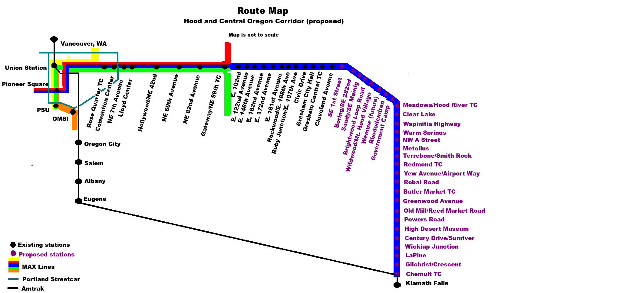
Twenty-seven new stops are planned as part of the route, with an additional stop in Wemme being designed for future service, when local land use conditions allow it. Planned stops include:
- SE First Avenue and Burnside Street, in Gresham
- SE 282nd Avenue, with service to Boring
- Sandy/SE Meinig
- Brightwood Loop Road
- Wildwood/Mt. Hood Village
- Wemme (future)
- Rhododendron, with service to that Dairy Queen that everyone stops at on the way back from skiing or snowboarding.
- Government Camp (underground)
- Meadows/Hood River TC (underground)
- Clear Lake
- Wapinitia Highway
- Warm Springs
- Madras/NW A Street
- Metolius
- Terrebone/Smith Rock
- Redmond TC, with Google Bus service to Prineville.
- Yew Avenue/Airport Way, with shuttle service to Redmond Airport
- Robal Road, serving northern Bend and Cascade Village Shopping Center
- Butler Market TC, with shuttle service to Oregon State University-Cascades and Central Oregon Community College.
- Greenwood Avenue, serving downtown Bend
- Old Mill/Reed Market Road
- Powers Road
- High Desert Museum
- Century Drive/Sunriver
- Wickiup Junction
- LaPine
- Gilchrist/Crescent
- Chemult TC, with connecting service to the Amtrak Coast Starlight.
Controversy
The project, still in the planning phases, is not without its detractors, and several obstacles lay in its path. First and foremost, a significant portion of the line lies within Clackamas County, which recently passed a county ordinance requiring that all future rail transit expansion in the county be voted on by County residents. Already, County Commissioner John Ludlow is opposed, calling the project a “waste of money” and a “blatant attempt by Metro to force high-density Soviet-bloc housing on the pristine slopes of Mount Hood”. Ludlow instead called for upgrading US26 to an Interstate freeway, and for the immediate construction of thousands of McMansions on the pristine slopes of Mount Hood, noting that such a project was sustainable as the timber clear-cut from the mountainside could be used to provide lumber for the homes.
The project would also require approval from the Confederated Tribes of Warm Springs, through whose land the proposed line passes. The tribe has not yet issued a statement on the proposal.
Finally, many Portland-area activists note that the Gresham-Central Oregon corridor was not identified as a high priority corridor in Metro’s 2009 High Capacity Transit System Plan, and all but a few miles of the 210-mile project lies outside both Metro’s jurisdiction and TriMet’s service area. A spokesman for Active Right of Way expressed dismay that Metro would even consider such a thing, given the backlog of maintenance work and new projects within the Portland area. But planners noted that the project was consistent with the goals of ODOT’s Mount Hood Multimodal Transportation Plan, and that by providing recreational users of the mountain with a reliable car-free way of reaching the ski slopes, highway capacity on US26 could be instead utilized by the freight industry.
Finally, several critics of the project have suggested that a Mount Hood routing is an incorrect choice, and instead have called for the Orange Line to be extended to Salem via Oregon City and Canby, and then east through Stayton, Detroit, over Santiam Pass, through Sisters, and then to Redmond and Bend. While such a routing would not provide service to the ski industry on Mount Hood (nobody, after all, wants to ski at Hoodoo); it would have the advantage of providing service to Oregon City and the Willamette Valley, as well as the State Capital. Plus, noted Bike Portland columnist Michael Andersen, “a Santiam Pass routing would give us an excuse to run mass transit through Camp Sherman. I can think of no better use of taxpayer funds than putting a light rail stop in Randall O’Toole‘s front yard”.
12 responses to “TriMet and Metro to extend Blue Line to Central Oregon”
They really dropped the ball with the Clear Lake stop. A stop at Skyline/nfd 42 would have way more TOD potential.
In all seriousness, are you aware of the existing, but never finished rail grade that goes up the Santiam River to the pass? A big chunk is underwater since they put in the dams at Detroit.
We could extend the 30 beyond Estacada to Ripplebrook and then west to such a stop.
The story of the old Oregon Pacific Railroad is an interesting one. Much of the line still is in operation–the stretch from Toledo to Albany (minus a small segment in Corvallis running up 9th Street that was long paved over), and the stretch of the current Albany and Eastern between Mill City and Shelburn. (The stretch between Shelburn and Albany is abandoned).
Er, east–not west.
Are they gonna put faces on the front of the light rail cars like Thomas the Tank Engine? Maybe they can put animal faces on the front instead!
If only this were true…
I hope they put bike racks on the front of the trains so that I can use my lawn chair, just like on the bus!
How would the fare structure work for such a long extension?
Would additional fare need to be paid for points beyond Gresham?
Would “Honoured Citizen” fares be provided?
Only if they bring no ski gear.
I like the name: “The H&CO” sounds like a real railroad!
Next I hope they build a line to Canon Beach, Seaside and finally Astoria. I love Astoria, and having regular train service would be so nice. It would certainly make the Yellow line more useful, and we’ll finally get that extension to Vancouver nobody wants. :P Of course, an alternate route could be that it turns west at Lombard TC, head to St. Johns, cross the St. Johns’ bridge, tunnel under Forest Park (with a stop under the park, perhaps near the Buddhist monastery), Bethany, Rock Creek, and then finally follow 26 with stops in North Plains, Banks, Nehalem Count Park, Canon Beach, then up 101 to Season, Gearhart, Warrenton, and finally Astoria. Just imagine the economic benefit to those communities having better access to Portland, PDX airport, and Union Station! It’ll be the perfect competition to Amtrak’s unreasonably comfortable coach bus service. I know I’d rather be on a dirty, hard MAX seat with head grease on the windows and people reeking of smokes and marijuana and BO. Who wouldn’t? :D
Engineer Scotty’s rant is best appreciated as satire.
================================================
“Island stations are fine some situations, just not 1st Ave SEATTLE.
Curbside bus service continues – less one lane if steetcar gets ROW – thus traffic congestion increases, bumper to bumper, jerky speeds predictably occur. Transit patrons then see bus or streetcar coming, dart into traffic, increased accident potential. The Curbside stop alternative route is a Streetcar Couplet on 4th/5th Aves. Interesting connection to Main St Line. Upgrades 5th Ave nicely. Safer. Probably the better connection to Alaskan Way where median stations seem okay. IOW, our problems are nowhere near as serious as the problems of those residing at more northerly latitudes and attitudes.
Sorry, I meant marvelous storytelling or something like that, satire?, instead of the word rant. Not a rant. Was hilarious.
I did rant about Seattle, rant rant, sorry. More funny stuff!