An occasional Portland Transport commenter and longtime reader, Nick Schillaci is a world traveler, who has been a foreigner on transit on every continent. He holds a humble BS in Planning and Public Policy from a little-known University of Oregon program, and has been a TriMet rider for decades.
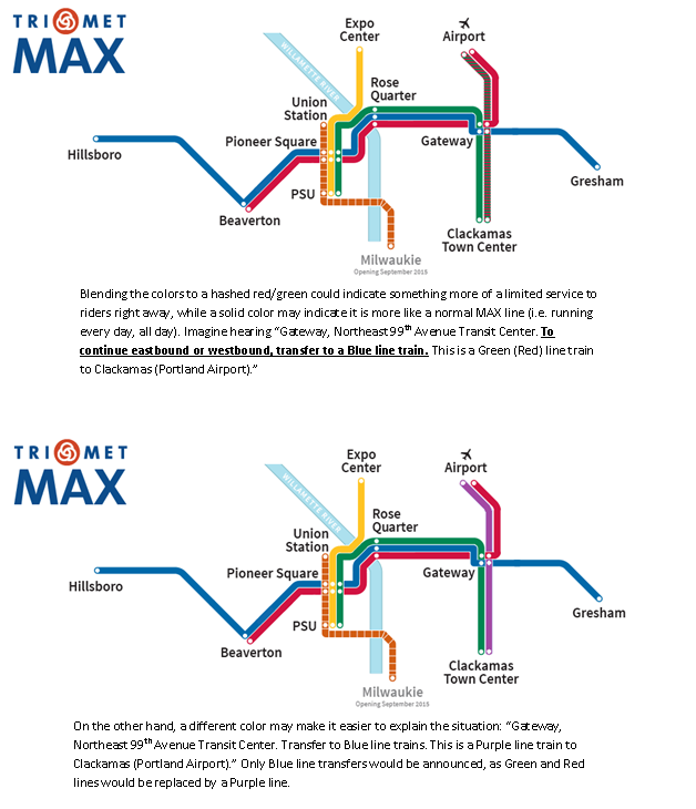
I greatly enjoy both Red and Green lines, and I don’t think we need any radical Green or Red line changes. I would never propose something as radical as to operate both Red and Green trains as the same line all the time. But could service be boosted from blending the Red and Green line trains? There is a lot of color-changing between Red, Blue, and Green lines in the evening, so simplification, frequency, cost savings, consistency, and mobility all come in to play.
Each weekday, between 8pm and midnight, there are 29 trains between Gateway TC and downtown (Blue, Red, and Green). This means there are about 6-7 trains per hour, or an average of about every 8-10 minutes. The Blue line alone operates at frequent service intervals until past 9pm, while the Red and Green lines operate less frequently. The Red line, in fact, ends service among the earliest of all MAX lines, with its last departure from PDX at just around 11:45pm when there are still about 15-20 arrivals at PDX (I’m counting some close calls, so maybe you need 45 -60 minutes to get off the plane, grab bags, and catch the last train comfortably, if it’s on time).
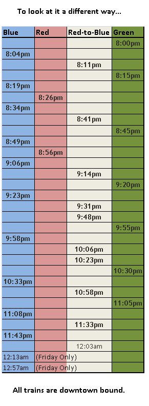
Extremely high inbound late night frequency aside, notice the redundancy and gaps. Trains at 10:23, 10:30, and 10:33, and then no trains until 10:58. Three trains in ten minutes, then none for 25 minutes.
Blue lines continue just about every thirty minutes through the end of their service, and Green lines, on the other hand, stutter to a halt (most continue east as Blue lines and terminate at Ruby Junction). Green line trains also stop operating relatively early. The Yellow line, for example, has a PSU departure an hour later than the last Green line. So given that very little service would be lost along Green and Red lines due to redundancy and service span of interlining routes, here’s what I’m getting at: evening-only service between PDX and CTCTC. The switches appear to all be there at Gateway for the trains to do such a thing. If you’d like to call it something more unique, why not call it the Purple line.
Because travel time between Gateway and Beaverton on the Red line takes a whopping 47 minutes (thank you downtown Portland) and travel time on the Green line between Gateway and PSU takes 25 minutes, over an hour and ten minutes is saved for each pair Red and Green lines that don’t continue past Gateway. Of course, this number doubles when they don’t return for a savings of 140 minutes (not counting layovers).
This all matters, because trains operating from Gateway to Downtown and beyond are all redundant service over the Blue and Yellow lines (and eventually Orange). How many riders would be turned off from a possible transfer to downtown? Some riders from the airport already may have to transfer (to go east or south from Gateway, East to Gresham, or beyond Beaverton).
With the time saved, a couple more Blue lines could be added at night to make up for the lack of Red lines continuing (especially since the Red departs Gateway later than the last Blue currently). This plan could also effectively boost Red and Green line service later in the night, with more frequency (a round trip between Clackamas and Airport would take about one hour). With the addition of the Orange line operating as a redundant Portland Mall line, no service needs to be lost through downtown either.
51 responses to “Rethinking I-205 MAX service”
How would you deal with the Red Line single track near Gateway TC during daylight hours that currently bottlenecks the system?
I think the idea of a Airport Clackamas TC run is an excellent idea except for two major issues, every train would have to be reversed at Gateway and two single track segments would still have to be dealt with.
Sunday I was riding Green to downtown and the train was held for 15 minutes at Main Street because of “congestion issues” at Gateway. Later I found out that it was a “switch issue”. After finally getting through Gateway I saw trains at dead stops between every station down to 42nd. Combine this with a “switch issue at the Rose Quarter, wooden ties that need replacing with concrete in major sections, I think TriMet has maintenance issues that are most pressing.
Also, TriMet needs to prepare itself for the flood of criticism it is going to get over the misnaming of the Orange Line. Mark my words, that criticism will be coming in many forms. The answer was simple but is probably too late to change now.
I like this idea. One operational drawback: the driver will have to reverse the train at Gateway. Would this create a bottleneck? Are we assuming all day service on this new Purple line?
How quickly can a driver (following all standard procedures) shut down the train from one cab, walk to the other cab, and restart the train (again, following procedures)? Can this be done (from a procedural point of view) while passengers remain on board? Currently, trains only reverse at the end of runs, with the passengers all disembarking–though new passengers intending to leave might be allowed to board before the driver has completely set up shop.
Some Green lines reverse like this already as they head to Ruby Junctionin the evening. It only takes a few minutes; I’ve been on them when they do so.
Yes please. About 90% of my travel on the green line is limited to the south alignment. More frequency would be fabulous. The other 10% is en route to IKEA/Cascade Station and eliminating the forced transfer at Gateway would be AWESOME.
I like the idea of having a “purple” line for clarity.
I think this is a great idea. I’ve always lamented the fact that Red Line airport service stops before the last arrival of the night. Seems like it should run until 2-2:30 am, like all other service, so that airport staff can use it to get home after the end of their shifts (plus straggling arriving passengers could use it).
Chris I, I don’t think the train would necessarily need to reverse at Gateway. The reason the Red Line uses the loop to enter Gateway from the airport is so that it can be facing the right direction to continue to downtown. If the train were to instead want to continue south, it would just enter Gateway using the other track — the one that Red Line trains use to exit Gateway for the airport. it’s all signal and switch controlled, so that shouldn’t present any safety or operational issues.
Now, if we could only redevelop Clackamas Town Center to turn it into a real village, with a street grid, dense mixed-use housing, a public plaza, a one-way couplet at the junction of 82nd & Sunnyside Road, and other features of walkable urbanity… then this line would have a real southern destination! ;-)
Garlynn,
There IS no other track; the airport approach to Gateway comes along from the north (heading south), narrows to a single track, crosses under the Blue line, then executes the 180 degree hairpin turn and enters Gateway TC from the southwest. Red trains from the airport entering Gateway then use the pocket track. Any train wanting to head south (or east) would have to reverse at that point. Trains coming from Gresham (or Ruby) likewise have to reverse; this is a big reason that most Red Line trains originate from Elmonica Yard and not Ruby Junction, to avoid having to change directions at Gateway.
Airport-bound trains use the same tracks, in reverse (except they don’t use the pocket track, they just use the normal eastbound track to serve the station than switch to the Airport line aftewards–but still have to go ’round the loop).
There is no wye or other siding or spur that allows Airport trains to anywhere but downtown without reversing.
Correction to second paragraph in above: Trains coming FROM the airport use the same tracks, in reverse….
This is a great idea, yet one that I assumed would only come to fruition at some point in the future when the I-205 MAX line extends south to Oregon City and (eventually) beyond. I’d like to see upgrades in Gateway so operators wouldn’t have to switch directions for such a route.
Also, I recall Trimet considering truncating the Blue at Beaverton and extending the Red Hillsboro with increased frequencies. (Does anybody know where this idea stands today?) It makes sense to me to have a PDX-Downtown direct connection, but it also seems intuitive that someday ridership patterns would call for a route that runs south to Clackamas.
Really though, the existing network design still highlights the old-Downtown-centric thinking. We need to be serving contiguous corridors. There’s no reason a rider should have to switch vehicles to get from one stop on I-205 (say, Holgate) to another (Parkrose). Now, unlike buses a lot of the time, at least you can switch trains at the same station and you don’t actually have to go Downtown. But we really should move towards a model where routes primarily serve contiguous corridors without getting caught in Downtown’s gravity. Downtown is a major destination and we should have high-capacity vehicles serving downtown at high frequencies from every direction, but this should allow most regular service to operate like the 70s lines do: with a high degree of utility while not wasting time Downtown. And there’s no reason this thinking can’t apply to rail routes as well.
Yes, I remember reading about TriMet’s proposal to swap Blue with Red line service beyond Beaverton TC. Currently, most Reds will continue to Willow Creek TC after 8pm (so they almost already do it in practice, just under the guise of Blue lines when they get to Gateway), which is why adding a couple Blue trains would be necessary for this plan to work.
I’ve tried to find when it was TriMet first proposed the Blue-to-Red swap out west, but I can’t find any of the old Transit Investment Plan documents posted (odd, TriMet is so good with posting ridership and documents – or maybe I’m not looking hard enough). Implementing that swap wouldn’t necessarily end this plan, it would just need to be reworked… possibly for the better.
For example, if a southbound Red turns in to a Blue line after 8pm at Gateway, I can’t think of a reason a northbound Red line couldn’t do the same and continue east instead of west while “Purple” line service is operational.
Think of it like a “night service” map at that point – one East/West trunk line, with two North/South branches… at night, Red/Green and Orange/Yellow lines would be essentially the same line, and the Red/Blue would essentially be the same line. Instead of 5 lines, there could be 3.
That is one possibility, at least. That’s just something I made up on the spot, so there’s probably some issues with doing that.
As for Oregon City, I definitely think that having a big “U” shaped line will make this concept close to inevitable (that is, to have a truly I-205 transitway as you mentioned). But as someone said, TriMet rail service is downtown-centric.
Crosstown rail trips would be a great thing. I wanted to show that it isn’t outside crazy thinking to minimally implement such an idea sooner rather than later.
I read about the red blue switch as well. However there was another part to the plan that involved the redevelopment of an office complex into a TOD project & creating a short spur line to it. This spur was going to be for blue line trains. http://www.nycsubway.org noted this project as well as a few other possible extentions including the linking of the green & orange lines.
Another option is to switch operators so they don’t have to walk from one end to the other
The problem isn’t the 200′ walk from one end of the train to the other; the issue is the shutdown and startup procedures and checklists.
I know that the Red line was built before the Green, but I think the current setup with the south-to-north hairpin track at Gateway is severely lacking. It is incredibly slow for trains, particularly inbound into Portland.
If we had an all-day service Purple line from Clackamas to PDX, it would make more sense for the Red line to bypass Gateway altogether. Continue east along I-84 after the 82nd stop and then turn north after passing under I-205 to tie in with the existing airport line. A double-track flyover could be built just north of Gateway, meeting these tracks about where the existing single track section splits back to two. This would double the service for the green line corridor and the airport, and would probably shave about 3-5 minutes off of the Red line schedule in both directions.
If we had an all-day service Purple line from Clackamas to PDX, it would make more sense for the Red line to bypass Gateway altogether. Continue east along I-84 after the 82nd stop and then turn north after passing under I-205 to tie in with the existing airport line. A double-track flyover could be built just north of Gateway, meeting these tracks about where the existing single track section splits back to two. This would double the service for the green line corridor and the airport, and would probably shave about 3-5 minutes off of the Red line schedule in both directions.
Been wondering about this my self. It could be done if the port contributed funds as they would receive tremendous benefits including the opportunity to set up additional economy parking & use max as a shuttle to the terminal. As an insentive the cost of parking should include MAX fares for at least four people if not more to attract families & not just business travelers.
With Gateway’s designation as a Metro Regional Center and long-envisioned as the “second Downtown,” it is highly unlikely that a route would – or even should – bypass Gateway TC. We should definitely be looking at streamlining the line from Gateway to the north, and double-tracking that segment provided that we increase frequencies enough to need it.
Have you read the book “Livable Portland – Land Use & transportation Alternitives” that TriMet puts out every few years? The last edition that came out in 2012 has a section on Gateway & it notes that turning that area into the desired TOD is challenging do to several factors. These issues include incomplete sidewalk networks, the industrial nature of the area & wide streets.
You can find a better description in the chapter on the Eastside pg. 52.
Ignoring the question of Gateway’s difficulty being redeveloped–Gateway TC is a major transit hub; it would do a grave disservice to many users who need to reach the airport (generally workers) if the Red Line no longer stopped there. Where else are they going to transfer to the Red Line? Far fewer buses serve Parkrose.
As far as Gateway itself goes, the two main issues are 1) The City of Portland hasn’t spent the money to transform the infrastructure, and it’s still a pedestrian-unfriendly environment, and 2) it’s already completely (or mostly) built-up, so redevelopment will generally require demolishing perfectly good buildings.
Given that redevelopment pressure is moving further east, it wouldn’t surprise me in the future to see more teardowns and rebuilds occurring east of I-205. The Stark/Washington couplet is just DYING for a makeover and a full Jenny Craig road diet (here would be a good place to spraypaint BUS LANE on the sidewalk). And better pedestrian/bike crossings (besides Stark, Glisan, and Halsey) over the freeways would help quite a bit too.
(And I’ve suggested before a through bus running parallel to I-205 from Parkrose to CTC or thereabouts, or possibly even to Oregon City, incorporating the 79. North of CTC, it could use 92nd from Sunnyside to Holgate, then east to 112th, then north past Adventist Hospital, Gateway, and ending at Parkrose.
Engineer Scotty,
Great turn a phrase with the Jenny Craig description.
Even though you say that the area near Gateway is currently built up, you know as development moves along the MAX system there will be demand to get the most from the land around the transit center. This may include a means to creat a faster routing for airport travelers not to mention a sight for an aditional garage for airport parking.
From what I have read recently, the port of Portland is struggling to manage the existing parking despite increasing the number of spaces last year. If the port Leverges the green line & creates a direct service to PDX from CTC, it may be a huge ridership generator & may even save the port money as they won’t need to build anymore on sight garages
Er, here would be a great place to spraypaint BUS LANE on the pavement, not the sidewalk. :)
You realize of corse if bus lanes were painted on the sidewalk, drivers could practice their wheelies. After all the best drivers take part in both state & the national bus rodios. I do know a driver here in NY who actually competed & won on the national level.
The Red Line would only be allowed to bypass Gateway if this proposed Purple Line existed and provided all day service. Gateway would not lose any service. Someone getting on at Gateway would still be able to take the Green or Blue lines to get downtown, and the Purple line to get to the airport.
Mrs Dibbly would love there to be a Purple line. :)
re: transfering to Blue from Red to go from PDX to Hillsboro… Aren’t there already some plans to make the Beaverton to Hillsboro stretch part of Red instead of Blue? (I always thought that made more sense, and I don’t live in Hillsboro.) I thought I recently heard some rumblings to that effect.
I’ve been on a number of late arriving flights that caused me to miss the last train. So even though I live right on the MAX line, I’ve been forced into getting an (expensive) taxi. So any proposal that would result in more late night service from PDX would be welcome to me, even if it required a transfer at Gateway.
On a different note, is there a reason PDX doesn’t shuttle service in the style of SuperShuttle?
I think Blue Star Bus may be one
I’ve often thought that the Red line at Gateway should work more like the Yellow line at the Rose Quarter. Perhaps this would allow not only double tracking all the way and the elimination of that damned hairpin turn, but could potentially allow a Clackamas-PDX line. That’s be a long term fix that would make it work so much better considering the track geometry. For the time being, having train drivers change from one end of the train to the other to continue south or east wouldn’t be that big a problem, at least not in the evening I’d think since there’s less service in general. That could be an option at least, and options are good things.
I also agree that having the Red line go full time past BTC to Willow Creek is a great idea. There really is a need for more service past BTC. I also agree that trains stop serving PDX far too early. There’s no (inexpensive) alternative either, other than a taxi and some $14 shuttle bus from the airport to Downtown which runs during the daytime at least. Honestly, I can’t imagine how that could make any money. Why spend $14 bucks to go Downtown on a small shuttle when you can take the Red line for $2.50? Makes no sense…
I think I’d propose something daring: instead of the Green line going to Downtown, why not have it turn north at the Rose Quarter and continue along the Yellow line? A hell of a lot of people transfer from the Yellow line at Rose Quarter to catch eastbound trains and vice a versa. From what I’ve witnessed myself on my many rides on the Yellow line, often at least half the train or more gets off to catch eastbound trains. I’ve been among them more times than not. It may require more transfers at Gateway for people going east and north, but that’s an easy place to transfer since it’s all cross-platform, never mind the many bus lines that converge there. That’s what’s good about Gateway (in spite of all the bad): once there, you can get in all directions very effectively.
Oh, and Gateway has one more big problem with redeveloping that wasn’t mentioned: two major freeways converge there, severely limiting its potential. There are a lot of people who live on the west side of 205 who have no short way to access Gateway. Parkrose has a similar problem in that it’s a long walk from any development because of its location. Some pedestrian bridges would help a lot of that at both locations. A fourth problem is that Gateway is ugly as sin. It’s old, decrepit, poorly lit, and the area has a seedy, neglected feeling about it. Building a more ascetically pleasing station, along with improved signage and way-finding, lighting, and bus stops could go a long way towards helping it. It would also be nice to uproot some of those parking lots and convert them to housing and shops and the like, similar to what’s at Beaverton Central or Orenco. There’d be eyes on the station, so to speak, and that would also make it feel much safer. That would make everyone happy, save for those who’d make trouble there.
Well, them’s my two cents. :)
The long-term vision for the Gateway Green area includes a pedestrian bridge connecting the area from the west and the east. Combined with the current north/south pedestrian bridge over I-84, this would greatly improve the walkshed for the Gateway TC. Improvements are also needed on the Glisan and Halsey overpasses. They are absolutely awful for cyclists, and pretty poor for pedestrians, as well. They need to extend the road diet on Glisan all the way to I-205, and add bike lanes on the overpass.
Gateway has a lot of those things in common with Sunset TC on the west side. They have the ped bridges but not a whole lot of development nearby just the same
Subway through downtown:
East portal between NE 7th and Grand. (Close 6th Ave). Cut/Cover tunnel to combined Convention Center/Rose Quarter station below I-5. Mezzanine access closer to Interstate MAX ‘surface station’, Moda Center and Convention Center.
(Yellow Line operation remains on Steel Bridge).
Twin tube under the Willamette, turn south to a Naito Parkway ‘stacked’ Cut/Cover tunnel for Saturday Market Station access on both sides Naito Parkway, covered elevator/escalator/stairs.
West portal beneath Morrison/Belmont bridgehead and connection to existing lines on Morrison/Yamhill. Close stations between 4th/5th. Combine Kings Hill Station (eastbound) and Providence Park Station (westbound). Close clammy station at Oregonian building and reopen Yamhill there to traffic.
This is a 1.3 mile subway with 2 stations; half the length of other subway notions and less disruptive construction. The ‘stacked’ cut/cover segment stabilizes waterfront soil. Travel time through town reduced 5-7 minutes. Slow crossover operation between MAX trains on Steel Bridge eliminated.
Oh wait, stupid me, terrible idea. Even thinking about it you will get EBOLA and die. Nevermind. La la la. Humdeedum.
How about those blazers?
Reducing travel time 5-7 minutes is good, but misses the other 10 minutes that should be removed.
Is it possible to construct this without shutting down the existing line? And this would still require a TBM to get under the Willamette?
I’ve had similar thoughts about a downtown subway (albeit longer, with fewer stops and the surface route replaced by streetcar) and I think eventually it will be worth seriously considering, but right now we can get more bang for our buck with other projects. We’re just seeing frequent bus service being proposed in several areas, we’re seeing other corridors looked at for High Capacity Transit (SWC, Powell-Division, TV Highway), let’s focus on lots of smaller projects all across the area, rather then a small part of downtown.
The gradient would be at the ragged edge of LRT feasibility for the alignment Wells is proposing. The elevation above mean river level at IRQ is about 75 feet, and the river is at least twenty five feet deep in its channel. Then one needs a minimum of twenty feet of overburden to seal the TBM. That’s 120 feet below current gradient.
Then, there is the much smaller, but nonetheless not insignificant change in elevation between IRQ and Seventh Avenue, about another twenty-five feet.
So the total gradient change would be very nearly 150 feet in less than a half mile or 300 feet to the mile; about 6%. AND, there would be a three or four car station which MUST BE FLAT right in the middle of the grade, making the gradient in the rest of the tunnel steeper.
Now there’s no doubt that MAX is able to climb a six percent grade, especially in a closed environment such as a tunnel. No rain, no snow, and especially, no ice. However, that station at Convention Center/Moda Center would be pretty deep. While it makes sense to have a deep station at the Zoo and we can hope one day under OHSU, for a major transfer point it makes less sense to push people into elevators.
But the more plangent issue is that such a tunnel does nothing to improve the coverage of downtown Portland served by the east-west main line. If Portland is going to undertake the expense of a tunnel, it should strive to do it right and rotate the axis of the main spine to pass through the length of downtown.
The way to do that is to start out exactly as Wells said: portal at Seventh with a combined Convention Center/Moda Center station under the freeway, but shallower so that escalators can do the job of the elevation change. The line would curve to the north under Interstate Avenue while diving down to reach crossing depth with a more normal gradient and becoming “stacked” as Wells suggests, so that the curve across the river can be symmetrical.
Between the Broadway Bridge and the northern grain elevator it would curve under the river and use the right of way of 9th Avenue to run south to a station for the Pearl district at Kearney. The Post Office is to be redeveloped so that would be a great location for a station. As the tunnel passes under the river, at its northernmost point a future connection to the Yellow Line should be stubbed in for the day when it does cross the river.
The line would curve under the corner of the Post Office parcel (we need to ensure that development of the parcel does not embargo this alignment) to run on south under Park Avenue. Cut and cover tunnelling is probably acceptable from the Kearney Station all through the north park blocks.
There would be a station lying between Park and Couch and Broadway and Ankeny, diagonaling under the bit of park south of Burnside and taking the old building in the triangle between Ankeny, Broadway and Burnside. This station should probably have a mezzanine connection to the bank tower. If the Burnside streetcar ever comes to be, this would be a great connection point for it.
From there the tunnel would run south under Broadway to just north of Pioneer Courthouse Square, bored and deepening as it goes. A diagonal station under the park would take the alignment over to Sixth Avenue where it would continue south to another station around Main Street for the government center.
Leaving that station the tracks would “stack” and about Market curve to the west to a station under Mill between Broadway and Park Street for PSU and the growing development in SW downtown. From there the alignment would continue due west under Mill under I-405 and the hill between the Vista Ridge Tunnel approach and Jefferson to an underground station a block or so south of the current Goose Hollow station and then to a portal just to the east of the Vista Avenue bridge supports. As at the north end, the stacked curve offers the Yellow/Orange line access to the tunnel through downtown.
Such an alignment serves all of downtown Portland except South Waterfront which is simply too far southeast to be included in the east-west trunk, but if and when the Yellow/Orange line is connected to the tunnel, it would be served by trains using the same platforms.
The existing east-west line could be served by a “local” between Sunset or Beaverton TC and Gateway, but the “through” Red, Blue and Green trains would use the tunnel.
Now I realize this is very expensive and would not make sense unless and until Portland grows dramatically. That would likely only happen as a result of climate change refugees seeking the relatively mild and wet northwest.
I’m mostly trying to serve the downtown to Rose Quarter/Lloyd District transit demand which this least cost/impact subway design would serve well with quick trips.
According to regional planning theory, outlying suburbs need transit investments and infill development more than city center, but the RQ and the inner Eastside is poised for major development. Regional planning also rejects any supposed need for 3-4 car trainsets and express tracks because in theory it reduces the need for cross-county commuting. Speed is the mindset of an automaton.
The Green Line needs an extension to Oregon City or to Milwaukie (and from there to Oregon City), and of course more station area development to complement the big box commercial crap. Transfers are inescapable as no transit system can reach its full potential without them. It’s simpler and more cost effective to affect convenient transfers rail-to-bus rather eliminate rail-to-rail transfers.
Thanks for the comments.
Well, there’s no doubt it would be a big improvement to get most of the trains off the Steel Bridge. But it’s a lot of money for a rather modest improvement in throughput and doesn’t get the main line any closer to the south end of downtown or the Pearl District where most development seems to be occurring. It’s almost as if the original line was laid out to avoid the developed parts of downtown. This would replicate that.
I certainly agree with the stop consolidation ideas. Those three pairs of stations are way too close together.
Regionalism predicts reduction of cross-county travel, eliminating the supposed need for express trains and 3 or 4-car trainsets. As for serving the Pearl District, the Yellow/Orange Line stations at Greyhound are within the 5-block convenient walking distance and the streetcar lines also serve well enough. Costs and construction disruption of longer subways only impede transit improvement, which is what some interests actually want. They’d be delighted to close that clammy Oregonian station at Providence Park and reopen it to traffic; an improvement for traffic on 18th from Goose Hollow to make only 1 Right turn instead of 2 Right turns past the westbound MAX station and then 1 Left turn. Don’t bite off more than you can chew.
I agree with the near-term focus on small wins. There is so much anti-MAX sentiment now that a big project — even something as reasonable as the Southwest Corridor with its hills and narrow developed area — likely cannot be LRT at this time.
But if Portland does get “selected” for growth by AGW, it will need for the east-west line to get through downtown more rapidly and reliably. The major axis of development in the region is parallel to the Columbia River. So a tunnel will need to be maximal, not minimal.
Portland’s MAX system is modeled on the U-Bahn systems in mid-size German cities like Frankfurt and Stuttgart, except that ours doesn’t have the “U!” Its an “onhe U” Bahn.
Getting that “U” is not cheap, probably $2Billion at this point. That’s a lot of dough to save 10 minutes, half of which could be achieved by consolidating stations: Providence Park/Kings Hill; Pioneer Square/Mall; and Rose Quarter/Convention Center. High quality design could help win the battle that such a consolidation would provoke. And maybe get the signals on the MAX line streets increased to 15 mph from 12mph.
I lived in Frankfurt a Main, when the U 6-7 replaced the 24 Strassenbahn between the university district (Bockenheim) and the central city (Innenstadt). I really enjoyed the easy daylight ride on the streetcar. Yes the U bahn is faster, but not memorable at all. Frankfurt bowed to citizens demands and kept most streetcars from that point on.
We should be spending money to get motorized vehicles under or away from the central city, not putting pedestrians and transit riders in tunnels. Remove I-5…move that designation to what’s now I-405, or put it under the River and the eastside; a better use of $2B in my view.
Much of that $2B could be paid for by selling the land that I5 occupies for development. That freeway is sitting on top of prime waterfront real estate, creating zero tax revenue for the city.
Just tell me where to sign for this.
Are you suggesting that I-5 gets rebuilt ala “The Big Dig” in Boston but on a much smaller scale?
Could I-405 be widened to three thru lanes? If so, do that and call it I-5.
Remove the Marquam Bridge and Eastbank Freeway; and do the proposed (approved?) widening of “old” I-5 north of I-84, and rename that I-84. So you offer some additional freeway capacity in exchange for the removal of the offending structures. No community with any pride would tolerate its river and waterfront being so degraded. Even the head of ODOT at the time, Glen Jackson, said they were mistakes.
Frankfurt, a city of about 600K, sits on either side of the Main River. What do they have on their “eastbank” opposite downtown? a row of about 10 museums, Das Museum Ufer!
Phil Goff, mentioned on BikePortland today, did a great “vision” exercise for the east bank of the Willamette. Michael A. can find it if its posted somewhere, maybe Phil’s website?
Or when you cross the Rhine River in Dusseldorf on the U-bahn bridge (also motor vehicles, etc.), and look down, what do you see? a big meadow! I saw a man grazing sheep on it one day in the middle of thriving city comparable in size to Stumptown.
The connection between I-84 and I-5 south has to be retained, even if I-405 could become I-5 through town. I’ve been fiddling with a Marquam bridge replacement design: single-deck, 4-lanes each direction, 4 piers, 3 ‘arch’ spans adjacent downriver. At the Hawthorne Bridge, the I-5 South ramp (nearest the river) is removed, the 2 higher ramps retained/modified. Westside ramps replaced with fewer piers gracefully. The I-5 ramp nearest the floating walkway is removed. I-5 is pushed east ~30′ from Burnside to Hawthorne. Berms quieten Espanade.
I don’t believe an I-5 tunnel is possible, nevermind in any way sensible. I suppose its north portal would be near the Morrison/Belmont bridgehead. Its 4 south portals somehow shoehorned into westside freeways.
Either way, a “single-deck” bridge will be considered when the Marquam finally must come down.
Who says it needs to be retained? 60 years ago, it did not exist. Portland should not be routing travelers on I-5 through downtown. Expand I-205, if needed. I can assure you, when it comes time to replace the Marquam bridge, the citizens of Portland will push ODOT to remove the east bank freeway.
We’re a bit off topic discussing the fate of I-5. But let’s keep it going on the next Open String.
So re a Purple Line…get TriMet scheduling to take a took once the task of getting the Orange Line and its bus network up and running is completed. Running a N/S service between the Airport and CTC in the evening and early AM hours sure makes sense to me; maybe all day if it can be done. What other possibilities are there: Red to Milwaukie? Green to Gresham? Yellow to Beaverton?
Ah, the mythical one-seat ride. How quaint.
What about a route from PDX to PSU if the single track sections are doubled & the area around Gateway were reconfigured so a purple service could also be possible. It’s a small area that could be the next growth opportunity for MAX if done correctly. This is despite the intersecting ramps of I-84 & I-205 of course.
Two Yellows a day each way used to go as far as Merlo. They turned into Blue Lines when they left Albina/Mississippi. They were headed back to the barn. (It always amazed me that they had a MAX tripper that was returning to Merlo leaving the Expo Center at 6:28 AM. Did it just make one round trip?).
Bjt it sure was nice for people working in or close to Beaverton.
Some early morning Blues go north on Interstate, making the trip to Swan Island that much easier; actually they are Yellow trains in from Ruby Junction. The original 1998 S/N Proposal had a maintenance yard south of Johnson Creek, but that was never built.
Actually, some eastbound Blues turn north at IRQ and turn into
Yellows. Made that mistake a few times coming in from Hillsboro :)