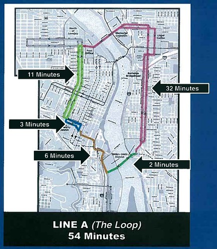
I’m working on a post to talk about some the issues around how we allocate service to the new Streetcar Loop line. While I’m working on that, here’s info on the cycle times for the various segments of the Loop (I’ve been asked about this here before and didn’t have easy access to the numbers):

8 responses to “Streetcar Loop Cycle Times”
Judging from that… a trip from OMSI to the Rose Garden will (eventually) be quicker if you cross the Caruthers Bridge, head up the westside of the loop, and then cross back on the Broadway, than it would be if you headed up Grand.
Or is the 32 minutes the round-trip time from Lovejoy to OMSI and back?
I believe the times map to the colored segments, so 32 min is OMSI to Lovejoy.
OMSI to Rose Quarter appears to be just over half of the ground covered in 32 minutes, so its probably safe to say it would be under 20.
If they’re saying 32 minutes I’m guessing that its just a pessimistic estimate so that they don’t look bad when it comes out faster
Between the Rose Quarter and the Lovejoy turnaround, the Streetcar will be running mostly on viaducts and bridges, not places with lots of stops. My assumption is that most of the half-hour will be spent on the stretch where there ARE stops every other block or so.
One more question. Given that the southbound journey involves an out-of-direction excursion towards Lloyd Center, is there any significant difference in the trip time between the southbound leg and the northbound–and if so, is the 32 minutes figure the average, the shorter, or the longer?
Keep in mind that these numbers are for service planning purposes only, so take them with a grain of salt.
Southbound does have out-of-direction travel, but it also has an exclusive lane from the convention center almost until Burnside, not sure how that nets out.
I am probably way out of whack but when I first looked at the map I had three routes in mind:
Route A same basic route as now from 23rd to south waterfront and back
Route B. 23rd across the Bway bridge to OMSI and back
Route C OMSI all the way around to south waterfront and back
Each segment of the system would have two routes over it. Might be less changing of trains but possibly undoable because of the differing segment lengths.
All the different car colors could cause son fusion I suppose.
John,
The current conceptualization is “Line A” (because it’s the original loop around the central City that Earl Blumenaur called for in his original idea for a circulation) from OMSI to as far as we can afford it (eventually a full loop back across the Milwaukie LRT bridge) and “Line B”, the current NW 23rd to SoWa line.
Personally, I’d love to see at least an occasional NW 23rd to OMSI service, but it’s not in current plans. I’ll have more posts about the service concepts and levels in the new few weeks.