Updated:
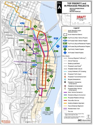
Here’s a diagram of all the projects on the table for South Portland. Lot’s of moving pieces!
|
from PDOT:
Open House for South Portland Transportation Projects
The City of Portland Office of Transportation is hosting an open house focused on transportation projects (and potential funding for the projects) in the South Portland Neighborhood which includes the South Waterfront District, the historic Lair Hill neighborhood and the North Macadam Urban Renewal Area.
Join us for an Open House!
5-8 p.m. Tuesday, October 7, 2008
David Evans and Associates, Willamette River Room
2100 SW River Parkway, Portland (served by Portland Streetcar)Information will be available for:
SW Gibbs Street. Pedestrian Bridge – See the proposed bridge including computer-generated pictures of what the constructed bridge might look like. The Pedestrian Bridge will create a link for cyclists and pedestrians across I-5 adjacent the Portland Aerial Tram. At the open house, the project team will have information to share about the selected bridge type, the plaza area on the east end of the bridge, and pedestrian improvements on the west end of the bridge
If you can’t attend the open house, you can review materials and complete an online survey at www.gibbsbridge.org. The online survey will be available through October 17, 2008. For more information, please contact Jody Yates at (503) 823-5835 or jody.yates@trans.ci.portland.or.us
North Macadam Transportation Strategy – Review the selected bicycle, pedestrian, transit, and motor vehicle projects. For more information, please contact Art Pearce at (503) 823-7791 or art.pearce@pdxtrans.org.
North Macadam Transportation System Development Charge (SDC) – View the proposed list of eligible projects and potential rates. For more information, please contact Kathryn Levine at (503) 823-7085 or Kathryn.Levine@pdxtrans.org
North Macadam Transportation Management Association (TMA) – review a proposal to start a Transportation Management Association that will serve North Macadam residents and businesses. For more information, please contact Dan Bower at (503) 823-5667 or Dan.Bower@pdxtrans.org
Representatives from the City of Portland Office of Transportation (PDOT), Portland Development Commission (PDC), Parks? TriMet? as well as consultants will be present to provide information and answer questions.
0 responses to “Updated: Sorting Out South Portland Transportation”
I’m curious, are they considering implementing the South Portland Circulation Study, re-connecting the different portions of the area cut up by Naito Pkwy, the Ross Island Bridge ramps, etc? That’s what I thought of when I saw “South Portland Transportation”.
Also, an idea for the area I’ve thought of is connecting Macadam and Hood Aves (the frontage streets along I-5) to Harbor Drive. Now, all traffic to/from Macadam (except I-5 north) has to go through the neighborhood.
hmm, kind of looks like a cluster. I mentioned last night at Transit Beer – maybe we can just get rid of the Interstate, that would resolve almost ALL of the transportation issues for South Waterfront. :)
It will be very interesting to see how SOWA pans out though, it’s becoming a nice area, albeit it isn’t being used for original intentions.
I’m still in favor of letting cars use the light rail bridge between trains on a toll basis, assuming the tolls from South Waterfront-to-eastside traffic would raise enough revenue to pay for the bridge. Think of how much less the “Orange Line” would cost (or appear to cost) if the entire bridge was “off-budget.”
Given that all traffic has to go through one of two bottlenecks at the north and south end of the district, I expect there’d be a lot of demand for a third access option.
Isn’t that map missing the LO Streetcar?
Also, while I like the idea of auto access to the new bridge, I’m worried about how much would be cut-through traffic from I-5, overwhelming the local traffic? It’s something that would have to be very carefully studied, at the least.
I hope it’s studied, but I’m not sold on it yet by any means.
That’s where the CRC failed too, trying to cater to everyone with an all-new structure. Why not build a new freeway bridge, and rehab an existing span for light rail, the other for pedestrians? That would possibly save about a billion dollars or so. Less weight too, which should make the bridges last longer.
The Caruthers Crossing bridge is similar, we have to figure out what’s the best investment. A tolled crossing might be, but it could also really crush the neighborhood with people trying to avoid the Marquam.
Dave wrote: Isn’t that map missing the LO Streetcar?
Good point – I wonder what the value of adding more bus service to SoWa when it simply duplicates Streetcar service.
I can certainly see a bus stop at Gibbs (to provide a transfer point) but otherwise, the busses should be running express through the area and allow the Streetcar to provide the local service.
How high above the SoWa is the Caruthers Crossing bridge? I suspect that even if people wanted to pay a toll and cross it, you wouldn’t do it from SoWa, but from Nato Parkway…
And just in case Rex Burkholder is reading: The bridges over the Willamette have been losing car lanes for a couple years now. The Burnside bridges used to be 8 lanes, and now is down to 7, (and has bicycle lanes,) and the Steel is down from 4 to 2 because of MAX… And if it was up to bicyclists, the St Johns would be 3 lanes (instead of 4,) and the Hawthorne would be 2 (instead of 4.) And this bridge will have 0 car lanes. So don’t use the Willamette river bridges to justify the CRC, we are reducing the number of lanes across the Willamette. Yes, those bridges did promote sprawl, but we are putting Portland on a road diet (okay, if cutting the ‘all you can eat buffet’ down a table can be considered a “diet”) and we are going to deal with this problem…
Seems to me that the single most important project for south downtown is the conversion of Naito from a decaying proto-freeway back to a community street. Whether it’s a grand boulevard like downtown (hopefully more grand though) or a more modest street design, this neighborhood is way too physically chopped up. I-5 is not going away, but the obsolete 99W freeway should. And soon.
we have to figure out what’s the best investment. A tolled crossing might be, but it could also really crush the neighborhood with people trying to avoid the Marquam.
I would hope that if toll traffic was allowed, the tolls would be demand-responsive … rising automatically when traffic is higher. That should moderate local congestion at peak hours. Also, if it were running straight into South Waterfront, I don’t think it would take much traffic off the Marquam, so much as from the Hawthorne and Ross Island bridges.
I suspect that even if people wanted to pay a toll and cross it, you wouldn’t do it from SoWa, but from Nato Parkway
If the bridge wasn’t touching down in South Waterfront, I don’t think there’s be much point in putting cars on it. The reason people would pay tolls would be for a “South Waterfront to Eastside shortcut.” No shortcut, no reason to pay a toll.
Let’s hope that the proposed move of the southbound 35 to Moody is provisional and will be evaluated after a reasonable period to see if it picks up enough ridership to justify the extra time in route for the 1000 or so current riders. The opening of the Gibbs pedestrian/cyclist bridge would be another evaluation point.
maybe we can just get rid of the Interstate
As I think I said either there or here, I don’t think that freeways should have been put through cities in the first place. Besides creating barriers that divide neighborhoods (unless there’s a bridge at every cross street like on I-405, which is very expensive), they bring pollution and require many people to be evicted from their homes and businesses. I have some old maps from before the freeways I might scan in soon.
conversion of Naito from a decaying proto-freeway
In the South Portland Circulation Study I linked to in the first comment, that is a major element, along with getting rid of the Ross Island Bridge ramps (traffic would use Kelly Ave in both directions and have more direct access to/from I-5).
Lastly, I’d like to note that for those boarding Line 35 at or near 1st & Arthur (say, transferring from Line 66 or an eastside bus) the plan would not mean just extra time, but an extra transfer and out-of-direction travel.