|
As the planning for the Milwaukie light rail line is refined, those responsible should consider other long range improvements that might be needed in the corridor so as not to require costly and disruptive changes to the line in the future, otherwise known as “Strategic Planning”.
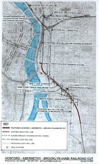
From SE 3rd to SE 17th Avenues, the proposed line runs parallel to the Union Pacific Railroad, the only rail line that connects the Pacific Northwest with Southern California with freight and passenger service. It will never be abandoned but, in the future, will have to handle many more trains than it does today and will probably require additional tracks.
This rail line is a major blight on the adjacent neighborhoods. The grade crossings at SE 11th and12th Avenues are major bottlenecks that will only worsen as more trains are added. Back in the 1970s, when Powell Blvd was dropped into a dismally designed underpass in order to relieve traffic backups on Powell, the street connections between the Hosford-Abernethy and Brooklyn neighborhoods were severed and the needs and safety of pedestrians and bicyclists were largely ignored.
Some day these shortcomings should be corrected and foresight is needed to minimize the cost and impacts of these future remedies.
A solution to this problem is to drop the grade of the railroad though this corridor so all at-grade crossings would be eliminated. Powell Blvd would no longer have to be in a ditch and local streets would again connect
It takes about three-quarters of a mile to drop the rail line down the 30 feet needed to run under 11th, 12th and Powell and the same distance to return to the surface. (See attached map.)
It would be infeasible to construct this cut at the location of the existing tracks because rail service cannot be interrupted for any extended period of time. The cut could be built immediately south of the line and connected up at each end (SE Clay Street at the north and SE Holgate at the south), at which time the existing track could be removed.
This leads back to light rail. Since property will have to be purchased to construct light rail, it would be prudent for TriMet and the City of Portland to purchase and reserve a corridor between the UPRR and the light rail line to construct a rail cut to accommodate the needs of future freight and passenger service.
10 responses to “A Hosford-Abernathy-Brooklyn (HAB) Railroad Cut”
This objective should be integrated into an overall study for improving the efficiency of freight movement within the Metro area.
The stated goal certainly has advantages for pedestrian, bike, and local road connections in those neighborhoods, but as you said, use of the rail corridor – a concern with regional implications – will only increase with time. We should bring those with interests in rail operations (BNSF, UPRR, Ports of Portland and Vancouver, ODOT, PDOT, Metro, and Trimet) to the table to discuss long-range goals and what it will take to achieve those goals, including reducing at-grade crossings in the region. Ultimately, the rail network was laid in a prior era and we need to wholly reconsider the rail network in a modern and forward-looking context that will help us to prepare for future concerns and improve our ability to compete with other ports on the west coast.
Sounds like a great idea. Is anyone working on this?
I always thought this would be a good idea, especially right now with Milwaukie MAX being in the design phase. However, I would think that continuing the new cut from the Brooklyn Yards to 7th Ave. then cut-and-cover 7th Ave. up to the Banfield tracks would be more appropriate for high speed rail and reducing freight rail delays (and 7th Ave. would be better than either MLK or Grand because it’s the same width of a street, but has far less traffic volume to disrupt). Anyway, just my 2 cents.
Flipping the over/under orientation of the Powell/RR crossing will be tricky at the current location, but worth exploring. I think grade separation through the CEID should be a higher priority though, or at least done at the same time as this proposal. Also, I don’t agree with Jim’s idea of the Yellow line completely bypassing downtown, but that’s a separate issue.
Love the idea of an eastside passenger rail hub between the Steele and Broadway Bridges…. makes perfect sense.
I like the idea of a passenger rail station there as well. I would make it an intercity bus station as well, taking advantage of the VERY close access to both I-5 and I-84. Amtrak and Greyhound in one building, with FOUR light rail lines, a whole bunch of Tri-Met buses, and maybe (someday) streetcars right out front.
And hey: if we ever run any kind of passenger ferry or river taxi service, the station’s right on the river.
The RR cut could also extend north to the Graham Line wye in its current 1st Ave. corridor but any street crossings north of Clay would have to be elevated to clear the track by 25 feet.
7th Ave. would be better than either MLK or Grand because it’s the same width of a street,
I believe 7th is quite a bit higher as well, making it easier to bury the line. But it seems to me Jim’s suggestion works whether the rest of the line ever gets buried or not.
The RR cut could also extend north to the Graham Line wye in its current 1st Ave. corridor
Jim,
Where is the “Graham Line wye”? What is the “Graham Line wye”? Not all of us are railroad buffs.
Ross,
The Graham Line is the UPRR Line that runs parallel to the MAX Blue and Red Lines. Currently there is no connection south but it is now needed for through routing UP E-S and S-E trains. Prior to BN buying out the SP this movement was not needed because they were separate railroads.
You mean “UP”, Jim, not “BN.” right? UP brought SP.
I’m reminded of the eventual need to bury the rail line (and increase its capacity for hourly Tago’s to Eugene), so that the Central Eastside can become our “New Town” of the 21st Century.
Burying the RR, along with removing the freeway and bridge ramps, will offer a pretty empty canvas for an entire new city.
There is another piece of planning that should be taken into consideration when burying anything in the CEID area – that of burying I-5 through the corridor.
The last idea that I read about burying I-5 in the district put it below MLK/Grand as a cut & cover tunnel (I think?); considering that rail lines can only have minimal grade changes, how would that interact with the rail line underground?
Placing a cut & cover tunnel for a freeway right next to the esplanade would likely cause major disruption to the path, as well as require expensive waterproofing to prevent the river from seeping into the dig when its under construction – but if it was several blocks east, it would likely be less risky and less expensive.
It should also be noted that the tunnel for I-5 under the river will need to be quite deep; certainly deeper than the railroad cut. The big pipe sewer project is 150′ as well, so all these tunnels are going to have to dance and weave together underground…
I would also suggest reserving the existing rail lines through the CEID for future MAX use for an eastside-bypass. While not needed currently, in the future there may be demand for passenger service from the Milwaukie line to the east side Blue line.
That could be planned to occur at about the same time as this RR-cut would be constructed, making it extremely cost-effective: all you would need to do is build a catenary system and connect it to the Rose Center Transit Center max lines.
It would at least make a lot more sense to recycle it than building 20+ blocks of rail lines parallel to 20+ blocks of rail lines that are phased out & removed.