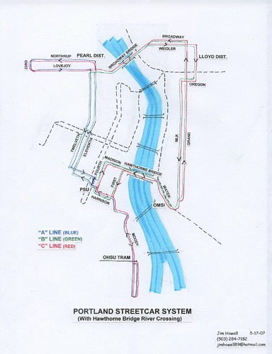
Jim Howell has an alternate notion of how to operate the Streetcar Loop. He’s paired it with a Hawthorne Bridge crossing, but I don’t know why it couldn’t work with a more southernly crossing, or indeed, before the crossing is created.
If streetcars were routed over the Hawthorne Bridge and south to Harrison, as I have suggested earlier in conjunction with an eastside routing of the Milwaukie/Interstate MAX, the streetcar system could operate as three overlapping lines as shown on the attached map:
“A Line” – the existing Northwest/South Waterfront line, “B Line” – An eastside/downtown loop and “C Line” – An eastside line that connects to both the Northwest and South Waterfront neighborhoods.
If each line were operated on 12-minute headways, a streetcar would pass any stop every 6 minutes and a passenger could travel to any destination on the entire system without a transfer.
|
21 responses to “Three Line Streetcar Service”
What is so intriguing with what Jim is suggesting is that it has all appearance of being more affordable and therefore permitting greater exansion for less cost.
The Broadway Bridge has effectively been rebuilt and can support putting Streetcar tracks back on it. To the best of knowledge that is true of the Hawthorne Bridge too.
Most everyone knows that I like Streetcars in the highly dense urban setting where they can truly eliminate the need of cars for many.
I also see Streetcars lines extended into neighborhoods like Sellwood, Hawthorne and Milwaukie, as having great potential of reducing the number of car trips and that is good.
I see Streetcars lines as much better and cost effective solutions for dollar then MAX/LRT.
What Jim is suggesting should be front and center in the current plan considerations.
This is a great idea, especially the 6 minute headway in any direction. How many vehicles would you need to run at any given time to achieve that?
I like the operations aspect of Jim’s proposal, although getting down to 6 minute headways is a little ambitious at this point. The problem I have with this (and I believe it’s well-known what Jim’s real goal is here) is keeping the Yellow MAX line on the eastside, forcing a very difficult tranfer for Milwaukie and Vancouver riders who are heading downtown. That would be an operational nightmare, IMO. I know the idea is to save the money for another bridge across the Willamette, but this will make Yellow line riders essentially second-class citizens.
A question for Aaron and Jim regarding the idea of keeping the Yellow Line on the east side:
Surely a significant number of inbound riders from Milwaukie and from Vancouver are seeking to reach destinations in SE Portland and/or the Lloyd District. Right now, a number of these riders must go downtown in order to make their transfers.
Those people, at least, would be well served by an east-side alignment, and the presence of a frequent pure N-S service would likely induce new riders.
The question is this: What is the ratio of riders who would be better-served by an east side Yellow Line vs. the riders who would be inconvenienced by needing transfers to get downtown, vs. the cost savings per rider? Has anyone studied the predicted numbers for these two scenarios?
Also, at least from Vancouver, it would not be inconceivable to continue running half the trains to downtown via the Steel Bridge (call this the Yellow Line) and also to Milwaukie via the east side (call this a new color.) In the future, a new river crossing at the south end of town could be constructed, and then all riders would have a choice of whether to go downtown or directly N-S.
– Bob R.
The problem I have with this (and I believe it’s well-known what Jim’s real goal is here) is keeping the Yellow MAX line on the eastside
Aaron –
I don’t see how this really has anything to do with keeping MAX on the eastside. Jim’s “real goals” are usually out there in your face.
Making transit across the river more convenient has a lot of value whether the Yellow Line is part of doing that or not.
Frankly, I think they ought to think about creating an “eastside bypass” for Max that takes some east-west trains around downtown instead of through it.
Ross said:
I don’t see how this really has anything to do with keeping MAX on the eastside. Jim’s “real goals” are usually out there in your face.
Yes indeed. Like drawing it on his route map, that shows a MAX line running down Water ave, and no bridge to cross from the south mall…
I already think they should run the yellow down the eastside, and with 6 minute headways on the streetcar, the transfer wouldn’t be that bad. But I have two questions:
1) We don’t have money to add a additional car this summer, but we’ll have money to add enough to get to 6 minute headways in 2011?
2) Can all the single track sections of the streetcar route handle that many cars?
I don’t think alignment capacity is an issue. But negotiations for operating funding for the loop are happening now and it’s challenging. I haven’t worked the math, but I suspect Jim’s plan requires MORE service hours than the current loop plan.
Ross,
I don’t think I’m inferring anything about Jim’s position that he hasn’t already stated publically himself. And as Matthew points out, his proposal for the Yellow line IS right on the map. My point is that FAR, FAR more people (and this is anecdotal, I don’t know where to get the exact numbers to back up this assertion) will….
A) be going to destinations downtown and/or will transfer to other MAX lines or buses than will….
B) be using an “express” bypass to points on the same Yellow line and/or transfering from the south end of the Yellow to eastbound Red/Blue/Green trains (or vice versa).
Now, if Jim’s map is just to show an “interim” proposal in case the southern Willamette bridge gets held up for a while, that’s fine. But I frankly don’t think it’s fair to SE Portland or Milwaukie to short change them again after they’ve waited so long for their MAX service.
Aaron –
I was not suggesting that Jim did not support keeping the Yellow line on the east side. As you point out, he has been clear about that. But I think his streetcar plan should be evaluated on its own merits, I don’t think it is just a stalking horse for his preference in MAX alignment.
My point is that FAR, FAR more people (and this is anecdotal, I don’t know where to get the exact numbers to back up this assertion) will….
A) be going to destinations downtown
Just to be clear, I agree on that. But the slow trip through downtown is a barrier for people using MAX to get between the eastside and Washington County. One suggested solution to that, a subway, is way off in the future if it ever happens. I think an “express” bypass on the eastside with only a couple transfer points should be looked at as an alternative once the bridges and track are largely in place.
My advice:
Use the Marquam Bridge to cross from SW Harrison St to OMSI. Extend Eastside streetcar south to Brooklyn neighborhood and, later to Milwaukie and Oregon City. Alternate destinations from Lake Oswego, Milwaukie, Nw Portland and Lloyd District terminuses.
This way the Marquam Bridge becomes the center crossing of an ‘X” pattern of routes that would be highly effective. There are some other details, but this is the essential gist of it.
Forget the Milwaukie MAX; it will be a ghost contraption most of the day.
[Personally directed comment removed – B.R.]
Ross,
I agree, the slow travel times through DT are a huge turn-off to people who must pass through DT or transfer to another line. The only realistic solution to this is a subway, which, as you said is even further off into the future now that they’ve committed to the second surface alignment.
In the meantime, we need to look at possible interim measures that could streamline operations through DT. I think the easiest to implement would be consolidating several of the Red/Blue stops so they’re not spaced so closely together. I’m not sure I understand your eastside bypass concept. Could you explain how that would work?
The transit mall project does appear to offer a slight travel time improvement for Yellow Line and Green Line riders compared to today’s alignment.
On the mall, there will be 3 after Pioneer Courthouse Square before reaching the river… on the existing alignment there are 5 stops. That will shave a few minutes off just due to dwell times and keeping up with signal timing.
However, the mall alignment also adds a rather complicated junction at the north end and a cost-saving S-curve which will slow operations (see Transit Mall Plans: A new pain in the S? from last November), so the net improvement will probably be about 2 to 3 minutes, tops.
However, any trips which would have required a transfer to get south of the current MAX to mall/PSU destinations will be improved because of the elimination of transfers. East-side riders anywhere between Rose Quarter and Gateway will have a choice of which trains to board (Red, Blue, Green) depending on where and whether they intend to transfer.
– Bob R.
‘m not sure I understand your eastside bypass concept. Could you explain how that would work?
Express trains run south from Lloyd Center or Rose Quarter, cross at Caruthers and add a track from Caruthers to Goose Hollow. You would have transfer stops at Lloyd Center, the transit mall and Goose Hollow. I’m not really sure how realistic that is on several levels, but that’s the idea.
Southeast has no real options for getting anywhere north of Hawthorne.
That needs to be fixed, and this type of service would help, but so would keeping the Yellow line on the east side.
With the number of busses that cross the bridges from the eastside to downtown, and the light rail at the north end – steel bridge – you cannot realistically claim that it would be a “difficult transfer” to get yellow riders from the east side to downtown.
On Powell alone, there is a bus from Milwaukie Ave to downtown about every 5 minutes. Hawthorne is a similar situation, and so from Rose Quarter there is always a train or bus heading downtown.
However in the inner SE area, there is only ONE way to get north or south across Hawthorne. Bus 70.
We need some good north south service in the central east side. The central east side is a dense residential and employment corridor. We need routes that go from Sellwood to North Portland, or keep the yellow line on the east side…
“With the number of busses that cross the bridges from the eastside to downtown, and the light rail at the north end – steel bridge – you cannot realistically claim that it would be a “difficult transfer” to get yellow riders from the east side to downtown.” – VR
Sure I can. None of the other MAX lines require a transfer to get downtown. Or, for that matter, most of the bus lines either. But you’re OK with Yellow line riders having to transfer. The difficulty is not the actual transfer to another bus or train into DT, it’s the fact that they would have to transfer at all. If you want direct service from Sellwood to N PDX, why not add another cross-town bus line along Milwaukie Ave, MLK/Grand, then as far north as you want to go. My guess is, if there was a demand for a through route like that (basically route 6 plus route 33), Trimet would have already implemented it.
The 70 and the 75 (and the 74 during rush hour) provide pretty good N/S options for people who live in SE Portland, of which I am one. For six months or so I rode the 75 every work day between 39th and Powell and St. Johns, it worked well for my needs. There just are not that many N/S main (through) streets that in SE, there’s 99E, Milwaukie/12th, 39th… and 82nd. There are major buses on those streets and I think they’re all frequent service.
While a spur that bypasses downtown might be appropriate, the main Milwaukie MAX line needs to go downtown.
70 does not go farther north than Lloyd district, and none of the busses on 99E cross Hawthorne (they all turn and go downtown over the hawthorne bridge).
So inside of 39th ave, there is no realistic N/S service.
Since yellow MAX would be close in, that is what we are speaking towards.
A few days ago, Matthew asked “Can all the single track sections of the streetcar route handle that many cars?”
Yesterday I was on a northbound streetcar from South Waterfront, and I remembered your question so I kept track of the time.
From the time the streetcar departs SoWa until it has completely navigated out of the single-track section: 2min, 20sec. (And this is hitting the traffic lights correctly.) If we assume a bit of overhead for signals, dispatching, etc., it means a streetcar can enter or leave SoWa every 3 minutes.
This means that 6 minute headways on that stretch are theoretically possible, but a single missed timing, even off by a minute, can cause a 3 minute delay and continue to ripple throughout the schedule.
The other single-track section surrounds what is known as Block 153, near PSU, bounded by 4th/5th/Harrison/Montgomery. It takes about 1min 30sec to completely traverse. There is a development proposal for this block which would eliminate some of the single-tracking, with one or maybe two tracks passing diagonally through the block, similar to the nearby PSU urban center.
– Bob R.
Thank you Bob. The solution is probably to double track that, which they’d probably want to do eventually anyways if they plan to go to Lake Oswego…
Related question: If a streetcar gets behind on the loop, is there any place where it can catch up? I’m referring specifically to the B line, where there just isn’t a good layover point… (A & C can have layovers build in at SoWa, and get back on schedule, but B is kind of tied to going in a circle…)
(This question actually applies regardless of Jim H’s idea or not…)
6 minute headways, with the current system, take Lovejoy for example, are impossible. Stacking would obliterate any type of frequency that would be maintained.
This has nothing of relevant importance, but we shouldn’t label Streetcar lines the same color as MAX lines. :o :p
Last point, you can have opinions about bang for buck, but for point to point prices of persons carried and usage the MAX obliterates the hell out of the Streetcar. The streetcar, next in line after a taxi, is by far the most expensive form of transportation in the entire city… well ok, “maybe” the aerial tram is more expensive too. The point though, is how much are we really willing to spend from the public pot to get the service we want? When do we start looking at cost conscious points of interest? When do we start worrying a little less about “appearance” and “politics” and start worrying about the goal of transportation in the first place. Streetcar does what MAX does, for less people at higher costs…
My main point, underlies my other notion that, honesty should be taken into account when talking about what a system does or does not do.
oh yeah… besides all that, it would be neat to have successful 6 minute headways, 3 service lines, and real Streetcar service that gets closer to its historically private equivalent of 60+ years ago.