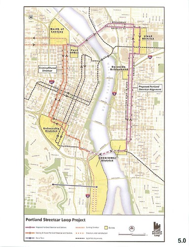
The project advisory committee weighed in on potential stop locations yesterday (indicated on image – click on the image for a larger version). Biggest debate was where to locate one between the Max crossing, Convention Center and State Office Building for maximum effect.
|
45 responses to “Streetcar Loop Starting to Feel Real”
The LOOP! YAY! Can’t wait for it to someday become a reality!
I have a question about the map…what’s the difference between “existing streetcar” and “existing and shared” streetcar?
The proposed “Loop” runs from (approximately) RiverPlace to OMSI. The westside part of this route is “shared” with the existing service, the eastside is new construction.
So 10th/11th are “existing/shared”, but Lovejoy/Northrup are “existing” because they are not part of the Loop.
I know there’s good reason, I’m just curious… Why the jog over to 7th Avenue? Why not just veer directly onto MLK?
Lots of parking lots ready to sprout buildings on 7th :-)
I can’t quite picture how the track along MLK/Grand at Stephens Street and the ramp over Division to the OMSI District will be laid out. It looks like a new stoplight at Stephens; and maybe a ‘single-track’ isolated line from Stephens to the ramp.
I’m also a little unsure about whether the turns from 10th and to 11th are even possible. Awfully tight turns – which is one reason why I still support making those turns at Hoyt and run past the Post Office to Broadway, close to the Transit Mall. You remember the transit mall? That transity-thingy place? An optional crossing for MAX via the Broadway Bridge would be good insurance should the Steel Bridge ever shut down. A MAX junction between Broadway and the transit mall via Irving would be simple enough. I won’t hold my breathe waiting for an explanation why not.
Switching at 10th and 11th is a hot topic. The current plan actually does not have vehicles traveling straight through but instead looping back at a new return track at Hoyt.
Both NWDA and the Pearl have asked for deeper briefings. Stay tuned.
I haven’t not gotten immersed in the details at Stephens yet, but will post when I know more.
jeez, that almost looks like a transit map for a real city. its kinda weird.
The emergency crossing for MAX argument:
Is that even possible? I mean, are the corners long enough so that the MAX could turn, and is the trackbed strong enough to support one, (even without people in it?)
I mean, I know new streetcar track could be built to MAX standards, but everything I’ve read says that it would be a lot more expensive than just building it to streetcar standards.
Oooh, so we still have streetcar stops that are only 2 blocks apart! Great! Did we not learn anything from streetcar on the westside yet? Don’t you guys know that rapid transit that transports people in a timely fashion is useful?
I really don’t want to spend an hour riding the loop just to get over onto the eastside. I rode the trams over in Amsterdam and Rotterdam, and they were FAST. Stops were widely spaced, shared the lane with buses in a transit-only lane. Portland Streetcar would do well to look at the functionality of the infrastructure they are building beyond “it’s pretty.” Not to mention the dollar savings by not having to build as many stations!
It would be sad if bus #6 could beat the streetcar along MLK…
Disclaimer: I am pro-transit and pro-streetcar, but this is just ridiculous.
If you just look at the map I think you’ll see that the average stop spacing on the map is greater on the loop than on the original alignment (compare MLK/Grand to 10th/11th). It’s more like every 3 blocks and each was carefully place to serve a land use or transit connection.
We do learn :-)
A MAX junction between Broadway and the transit mall via Irving would be simple enough.
Here’s an idea if they don’t want to have both the NW 23rd and eastside lines use 10th/11th: Connect the loop line to 10th/11th…and connect Northrup/Lovejoy to the mall, replacing some of the shuttle (mall-only) trains.
Chris:
Zilfondel has a point. While I do agree that you’ve gotten better there are still at least a couple more stops than there needs to be. You definitely want to have a stop at every bridge, and one stop between the bridge seems reasonable too, but there seems to be one stop too many between Morrison and Burnside. Portland has short city blocks, if you put the stop at Oak the furthest anyone is going to have to walk is one extra block. Or just put it at Stark and make some poor soul walk two extra blocks. The Lloyd district seems similarly overserved. If you can knock one station in each direction it wouldn’t look quite so bad.
Any time you’re putting two blocks between stops in Portland you’re doing the streetcar a disservice. Its currently alignment has proven that too many stops will make it too slow (I can and have walked from Lovejoy to Alder in the amount of time it takes Streetcar to run the same trip). I urge you to do your best to make three blocks between stops the minimum for future streetcar expansion.
Noted :-)
Having the Broadway Bridge tracks run down to Hoyt will make for a bit of out-of-direction travel for streetcars,especially running between the eastside and 23rd, no?
Caveat: I am not an engineer. The tightest curve I can see would be from NB 10th to EB Lovejoy. I expect that could be swung out a bit by having bridge-bound streetcars move into the left lane of 10th a block or 2 south, then have a dedicated signal at Lovejoy for them to turn across the right lane.
Streetcars WB on Lovejoy wanting to get up to Northrup via 10th could either turn from a center land of a reconfigured Lovejoy and/or swing into the left lane of 10th, and back into the right lane soon after.
Streetcars turning south from WB Lovejoy onto 11th shouldn’t have much of a problem, it is from a far lane to another far lane from a two-way street, so there wouldn’t even need to be special signaling. The remaining direction doesn’t require a turn at all, streetcars EB on Lovejoy from 23rd just need a straight track on down Lovejoy.
With some rejiggering of the 10th/Lovejoy intersection the streetcar network in the Pearl would be much more straightforward and direct.
Are there plans to have connections to allow streetcars to turn back at either/both of Weidler/Grand or Oregon/Grand, in either direction? I am thinking like a small track section akin to SW Market/10th. Adds service flexibility to the network.
Will the existing maintenance and storage facility be adequate for servicing the expanded network? Are there plans for additional storage tracks anywhere, for event service for example?
Regarding the stop spacing, they do seem a bit close still to me in some areas. What are the projected trip times like?
Were connections to Union Station studied? There doesn’t appear to be a good way for pedestrians to get from a streetcar stop to Union Station or vice versa. The Post Office really gets in the way here.
I really agree with the comments about the frequency of stops. I often don’t use the streetcar because I can outwalk it (unless I time the stop just right).
I’m not sure what the optimal spacing is- actually my feeling is that inner city Portland bus stops are too close together as well- have any studies been done? Is there any thinking about this for the future?
Chris –
I’m with Doug and Zilfondel on this one… in fact Doug’s suggestions for combining a stop near oak and combining a stop in the Lloyd district would be just about right. With 3-block spacing, the furthest anyone would have to walk (along the street face once they arrived at the main street) to a stop would be 1.5 blocks. Even 4-block spacing is not major burden with Portland’s short blocks (but I wouldn’t go more than 3 or 4 for streetcar in the primary service areas.)
Bill –
Regarding Union Station access, it’s not perfect, but with the recent construction in the area there is now a sidewalk that leads directly from the NE corner of 9th & Lovejoy, around under the Broadway bridge, to Union Station. (See this Google Map.)
The total walking distance from that corner to the door of the station (including crossing one low-traffic street) is about 700ft. Not the shortest walk in the world when you’re dragging luggage behind you, but better than most airport concourses. (Concourse A at PDX is about 1,400ft long, but of course it rarely rains inside the airport.)
– Bob R.
i have to agree with everyone else, there seems to be 2 or 3 too many stops, besides combining stark + pine into one stop at oak, you could easily remove 2 stops in the lloyd district. i am imagining the excruciating delay right now, and it hurts.
you mention that each stop was carefully placed to serve a land use or transit connection, i for one would find it very interesting if you wrote a post about what those were (even if some are totally obvious). you could make it simple and just add descriptive notes directly on the flickr image itself.
also, sorry if i should know this, but once the caruthers bridge is completed, am i correct in thinking that there will be streetcars constantly running in each direction?
Just to clarify, out-of-direction travel via Hoyt is only required between the eastside and NW, not for normal loop operations. When I have a more detailed understanding of how this will work, I’ll post about it. I’ve been pushing for operation from NW without out-of-direction travel so that in the future you could conceivably have service from NW 23rd to an eastside destination like Hollywood or Hawthorne.
I hear the concern about too many stops, and made the same comment myself at the last meeting. My point was that rather than designing for every two blocks as was done on the westside, this process was more targeted. That doesn’t mean there isn’t still room for improvement.
Next month’s project meeting will review the development strategy. That should give me more to post about individual locations.
And yes, this is called “the Loop” because once we have a Milwaukie LRT crossing, we’ll use it to make this a true loop route, with cars running in both directions.
I personally believe that a good stop spacing would be every 4 blocks – that way the max anyone would have to walk is 2 blocks. Placing them every 3 blocks means that, assuming a 2-block walking radius, that there is a 1-block overlap between any two stops. This isn’t too effective from speed of system and people’s time…
Don’t forget that faster streetcars = more frequent service in the big picture, since you won’t need as many streetcars.
The best part of the current streetcar line is the segment between South Waterfront and Riverplace… it covers a lot of ground really fast – and maximizes its’ usefulness.
Chris –
Speaking of faster streetcar service, I’ve been meaning to ask about the timeline for upgrading the trackwork in the vicinity of SW 4th and Montgomery.
(There are proposals to redevelop that block and allow the streetcar to pass through diagonally like it does at the PSU urban center.)
Not only would this reduce travel distance a bit, it would remove two or three tight turns and hopefully remove 2 blocks of single-track operation.
Is this a done deal now that construction activity has begun in that block? Do you know if it will be single-tracked diagonal (with a merge from 5th) or (preferably to me) double-tracked all the way from Harrison?
Back to stop spacing… at the risk of starting a controversy, I would like to explore a change to the existing stop spacing which would dramatically improve transfers with MAX.
Right now, to transfer between MAX and the southbound streetcar requires walking 2 blocks and crossing 3 streets, whether you use the stop at Alder or the stop at Taylor.
If the Taylor and Alder stops were to be combined into a single mid-block stop on 11th between Yamhill and Morrison, the walking distance required would be slightly reduced but (more importantly) the number of streets crossed to make a transfer would be reduced.
It’s subjective, but I feel that street crossings are more of a barrier to effective transfers than mere walking distance.
The location of the new station would be mid-block adjacent to the MAX turn-around tracks. There is already a small plaza area there with seating, currently underutilized, which would be perfect for a station.
More importantly, when streetcars cross through the MAX area they are often delayed… why not pick up some passengers during this time?
The big downside: Combining these stations would make for a big gap… 5.5 blocks from the Couch stop and 5.5 blocks from the Jefferson stop. That might be too much, especially given development in the area, and I’d understand if the local resident’s wouldn’t be keen on the idea.
Further, Burnside is still a barrier, so the 5.5 blocks from Couch will seem pretty tough to some, so I wouldn’t propose moving forward with combining stops unless the Burnside/Couch couplet is also a Go.
– Bob R.
Re: Jason McHuff’s comment, “..if they don’t want both NW 23rd and eastside lines to use 10th/11th, connect the loop line to 10th/11th, and connect Northrup/Lovejoy to the mall..”
A reply: The demand for more streetcars on 10th/11th justifies shared route there. Plus, NW 23rd to Lloyd District is both simpler and more ideal.
Though, I agree that a direct route from NW 23rd to Lloyd District is a good idea, would four rail ‘turns’ onto/from Lovejoy be too cumbersome for that busy street?
I must warn that 9th and Lovejoy is a very dangerous intersection. A westbound-to-northbound ‘turn’ might be better at 9th rather than 10th, if only to build a “road surface signal” to motorists that the 9th and Lovejoy intersection isn’t a racecourse. A right turn at 9th and a left onto Northrup could be simpler, maybe.
It should be mentioned that the North Park Blocks and the Post office also become accessable via Hoyt.
The 4-block stretch between Hoyt and Lovejoy (the Jamieson Stops) would have a service decrease; not a bad place for dilly-dallying waiting for the trolley.
Thanks Chris, for addressing my concerns. Great picture in the WW!
It’s nice to see this discussion happening. Chris has often pointed out that the streetcar is at least as much about spurring development as it is about moving people. However, improving its efficiency can further the latter without affecting the former, so it seems a worthwhile goal.
Bob’s suggestion about combining the Alder and Taylor stops is very good. 5.5 blocks between stops is not excessive. That’s about 1100 feet, or just over 1/5 of a mile. So the most an individual would have to walk is 1/10 of mile if they were between two stops. That should be entirely acceptable. As it stands, the best feature of the close stop placement is that if you miss the streetcar narrowly at one stop, you only have to jog lightly for two blocks to catch it at the next. While I’ve certainly taken advantage of that “feature,” it’s not indicative of an efficient transit system.
Consolidating the stops on the west side – and spacing them further from day 1 on the eastside – is imperative if we want the streetcar to be more than just a development tool and neat gadget for tourists to take photos of. It can still remain both of those things while simultaneously moving people effectively and efficiently. That’s the only way to gain the next level of public support needed to really grow the system.
As much as I hate the “toy train” label, there’s some truth to it. But there doesn’t have to be.
I’ve been meaning to ask about the timeline for upgrading the trackwork in the vicinity of SW 4th and Montgomery.
I know things are beginning to happen, but don’t know what the timeline is.
Consolidating the stops on the west side…
I suggested removing a stop in my neighborhood and was almost run out of the room on a rail :-)
Someone explain for me: this map shows a new bridge carrying both light rail and streetcar traffic. does that mean that light rail and streetcar are able to share the same tracks?
the mind boggles … for one thing, with this mlk/grand track in place, it’d require just a tiny bit more infrastructure to create an “eastside express” light rail route that skips downtown entirely. that would be huge for the east side.
Mykle –
Light Rail and Streetcar vehicles can indeed travel along the same tracks if the conditions are right.
However, LRVs are wider vehicles than streetcars, which means that the platforms have to be further back from the rails. This can make boarding a streetcar incompatible with safety and/or ADA regulations.
However, future streetcars could be engineered to have automatically-deploying “gap fillers” (this is not a completely untried idea) that extend out whenever stopping at a shared platform.
Streetcars can also make tighter corners than light rail… anywhere a route is installed that needs to make a very tight corner, it may therefore become incompatible with future MAX use.
The other issue to consider is that because the streetcars are lighter, the trackbed for streetcar-only routes can be more shallow, which lowers costs, speeds installation time, and reduces the need for utility reduction.
To install tracks in a corridor that MAX can operate on in the future would increase the cost of that trackwork.
Chris – can you elaborate on any discussions that have occurred to make the MLK/Grand tracks MAX-compatible for future expansion?
– Bob R.
One of the requirements the local steering committee put on the Streetcar Loop project was that emergency dual-operation on MLK/Grand be evaluated. I have not heard a status on that analysis recently.
Ditto on Bob R., zilfondel, and others.
I’m gonna be seriously bummed to see the streetcar keep up the same lagging service in the expansions that are planned.
Let’s GET IT GOING. This whole, “let’s do stuff like Europe” and we still can’t get it right. What the hell!?!?
Makes me wanna throw my hands up in frustration. Will I ever be able to expect decent service? Will it ever be even remotely close to what existed in the past?
Two suggestions in this plan:
1. Streetcar could use the existing structure of the Marquam Brdge which would bring it to the same vicinity as the proposed bridge. In fact I think it even brings it closer to the entrance of OMSI and to PCC.
2. A spur southward (remember how easy it has been to extend the Central City line incrementally southward in South Waterfront?) into the Brooklyn neighborhood would give those residents access to the Streetcar system, and placate those howling for the much more expensive MAX train. South of the Brooklyn neighborhood you just are not going to find many transit riders until you get all the ways down to Milwaukie–and they could use an express bus.
I hope my point is clear. Or would it be better to call Mr. Rogers to explain it to you?
Oooooh, it would be so nice; no transferring to get from the Doug. Fir to the Lowbrow Lounge….
Yes, it’s possible that the MLK/Grand streetcar line could accommodage MAX trains, either as secondary route to the westside or as through N/S route. But, a MAX secondary route to the westside is just as logical, and probably moreso across the Broadway Bridge. The out-of-direction travel time/distance between the Rose Quarter and the Transit Mall is much less via the Broadway Bridge. For me, after first suggesting this alternate MAX route to the westside, it is disheartening to watch the MLK/Grand route take front center stage, while the Broadway Bridge route is still ignored. Certainly, the Yellow Line can ideally junction at Larrabee and reach the Transit Mall with little out-of-direction travel time. Good grief.
It’s doubtful the Marquam Bridge can form the structural base for a streetcar/light rail line. One day, I’ll surmise that the Marquam will be demolished and I-405 become I-5.
Ron –
My personal view is that while the idea of using the structure of the Marquam bridge is intriguing (I don’t know about the technical feasibility), it creates too many problems for the future.
The Marquam is widely regarded as one of the ugliest bridges around (although in a utilitarian sense it does the job it was designed to do reasonably well), and if there is a future consensus on what to do about I-5 (leave it alone, widen it, move it, bury it, eliminate it, etc.), it is likely that the Marquam Bridge will be replaced or simply removed.
I’d rather not have the additional complication of a transit deck on the bridge (which could also make it even more visually obstructive) get in the way of future decisions about I-5.
Still, from a practical perspective your idea might lead to some interesting studies: It would be interesting to see plans that say a new transit bridge would cost $X while adding transit to the Marquam would cost $Y.
– Bob R.
Why is it that the loop needs to run on MLK/Grand? It’s the busiest north/south throughfare before 82nd/I-205!
When the Union Pacific expands their intermodal yard in Brooklyn after the 99E overpass is reconstructed, there’s just going to be more trucks thrown into the traffic jam. The streetcar really should stay one or two blocks east or west of 99E.
If people can walk one block from the Transit Mall to use the temporary Mall… Then people can walk from MLK to 6th/7th, after all it’d be safer for pedestrians than trying to cross MLK/Grand, a HIGHWAY!
They want to route it down 7th Avenue because that’s where TriMet’s Capital Projects office is located. The “Lots of parking lots ready to sprout buildings” argument doesn’t quite work when you look at the rest of the streetcar alignment. If Portland really wanted to go with that analogy, then the streetcar would run down 2nd/3rd in inner-eastside, or 7th south of Sandy Blvd.
Lee, the Streetcar will go down MLK/Grand because that’s where the mixed use zoning is in the Central Eastside. The district was very clear that they did not want Streetcar if it was a driver for rezoning the Industrial Sanctuary to something else.
“Still, from a practical perspective your idea might lead to some interesting studies: It would be interesting to see plans that say a new transit bridge would cost $X while adding transit to the Marquam would cost $Y.”
I am not an engineer but I do have considerable experience in construction, including concrete work. The Marquam Bridge is set on immmense concrete pilings which are tied together by equally immense concrete beams. If it was built now it would have much more steel rebar, but I’m sure it has plenty. The significant weight that these pilings are carrying are the steel girders which in turn support the concrete freeway decks. Any steel rails supported by those lower beams would be negligible compared to the freeway decks.
A lift span would be needed, but with girders directly above I would think that those could support any lifting mechanism needed to raise the appropriate length of track. Given the immense weight of the Marquam as it was constructed I would think that it was placed on something more substantial than river mud, albeit seismography in Portland was in a much less developed stage in those times.
If the Marquam Bridge were removed, it will only be as part of a hugely expensive reconstruction of the I-5/I-84 interchange in the Portland area. It would make the “Big Dig” in Boston look like amateur hour. It’s not surprising to me that some of our New England transplants seem to be most in favor of this. Do we have a successor to Edward Kennedy in our congressional delegation, or what?
I agree that Central Portland would be much prettier if this happened. However, I would like to keep asking why Central Portland should be awarded with huge, costly projects when relatively little is done to improve other neighborhoods? If I owned some warehouses west of Grand Ave I likely would be jumping on the bandwagon for I-5 replacement. But I don’t. So it won’t get my support, unless it can be shown that my neighborhood stands to benefit equally, and, furthermore, that these projects are defensible in light of serious strains on the US budget.
Since what is called the “Harrison Connector” is already pointed at the western piers of the Marquam, sending the SC straight ahead, besides turning on SW Moody, probably wouldn’t cost too much more than the aproaches, alone, for the proposed bridge.
This why I have suggested to Ross W. that commuter rail for Portland is largely in place with present projects. I would add a Streetcar line from Tigard to Vancouver via Front Ave.
When can I ride it?
Best case 2010 or 11.
The district was very clear that they did not want Streetcar if it was a driver for rezoning the Industrial Sanctuary to something else.
What kind of development would the streetcar be driving then? We’ll have condo towers along the “highway” with new industrial plant going in next door, in the very underdeveloped industrial area? This makes no sense to me.
Has the Portland Streetcar Inc ever drawn up a vision of what they see the streetcar line building out with?
Has the Portland Streetcar Inc ever drawn up a vision of what they see the streetcar line building out with?
– 4000+ new housing units
– Substantial office development in the Lloyd District
– Some modest increase in the intensity in uses in the industrial sanctuary
– A catalyst for the new district coming together near OMSI
– The anchor for a city-wide Streetcar network
Why not skip the streetcar and just fork over the subsidies.. I am sure we can get a nice farm of McCondos without the added expense of the streetcar.
I would add a Streetcar line from Tigard to Vancouver via Front Ave.
I can now honestly say that riding the 12-Barbur Blvd. bus isn’t all that bad.
Top speed of a Streetcar is around 35-40 MPH.
There are several stretches of Barbur in which busses can do 45. (Actually I’ve been in busses that have done 55, but the legal speed limit is 45.)
Not to mention that Barbur Blvd. is very hilly; which would necessitate that Streetcars go slower.
Why, just why would we replace one mode of transit with another that would offer less service and is slower – and on top of that would remove vitally needed transportation infrastructure (Highway 99W between I-5 and downtown Tigard) with absolutely no alternative?
On the other hand, if the City of Portland wants to waste their money on a Streetcar line to Barbur TC (which is a waste of money just because it goes nowhere, but that’s the City’s decision), it’d be fine by me – after all it’d take Barbur Blvd. off the state highway system, and allow TriMet to finally run the 12 as an express bus within Portland city limts.
Meanwhile, I’ve offered my proposal of a MAX line between Portland and Tualatin that would serve Burlingame, Multnomah Village, Garden Home, Washington Square, Tigard, Durham and Tualatin – a true “express” service compared to other MAX routes (stops would be approximately every two miles apart, with a couple of segments 1.5 miles apart, and the first station out of downtown Portland would be three miles out) and certainly very bus route in the region, that offers far more benefits and connects more “community centers”; and allows for the area’s bus network to become feeders instead of providing redundant service, and makes a number of low-patronage bus routes more efficient.
Office Towers? Office developments in the Lloyd Center District? Office development generates the most suburb-to-city commuting. Every day at 5 o’clock, Lloyd District office workers drive away in long impatient lines. I thought the development was to be condos. The goal should be mixed use development, not just more, sterile, worker bee, office towers. Good grief.
The goal should be mixed use development…
I believe I mentioned 4000+ housing units. Housing combined with office = mixed use.
I thought Chris meant 4000+ apartments in SoWa. As Zana Roseanna Dana always said, “NeVermind”.
zifondel, your point about stop frequency is so very important. I would say distances of four blocks is perhaps even too short for a minimum requirement. Portland blocks are TINY. Walking two city blocks in this town is equivalent to one in most major cities. So asking people to walk a maximum three city blocks to a streetcar stop (which outs stops at every six blocks) is like asking people to walk a measly one-and-a-half city blocks anywhere else. And the payoff? A real rapid transit system, not a tourist tram. People will walk farther to the streetcar if they know it will actually get them somewhere. Added bonus: walking’s good for you.
Chris wrote: I suggested removing a stop in my neighborhood and was almost run out of the room on a rail :-)
That’s a good reason why it is important to be conservative about adding stops to the initial route. It is far easier to add a station later if ridership/development warrants than to remove a stop once the system is operating.
– Bob R.