Regular readers will recognize Bob Richardson as “Bob R.” who has provided many cogent and informative comments. I’m happy to now welcome Bob as a Portland Transport contributor! – Chris
The Rose Quarter area is one of the most intense mix of transportation modes in the city of Portland. Three (soon four) MAX lines converge there, Interstate Avenue, Multnomah and Oregon streets intersect with approaches to the Steel Bridge, and there are multiple bus lines using the Rose Quarter as a transit center. Nearby, but not directly intersecting, are freight/passenger rail tracks which cross the Steel Bridge to Union Station.
A complex layout of light rail “interlocks” (track switches) and traffic signals orchestrates the flow of traffic in multiple competing directions.
As some transit advocates (including AORTA) have pointed out, the capacity of these interlocks constrains the potential for growth of the light rail system. With the addition of the MAX Green Line from Clackamas, the area may approach the practical limit for trains per hour of throughput within a decade.
Expanding capacity beyond the current limit presents a conundrum: How do you redo this complex interchange without shutting down the current rail system, which would have drastic short term and medium term impacts on ridership? Furthermore, how can the area be configured to accommodate future proposals such as a new river crossing (bridge or tunnel) or longer trains?
I propose the development of an underground station at the Rose Quarter for the Blue/Red/Green lines in a manner which presents many options for future expansion, eliminates several current conflicts, and provides greater rider convenience.
Full details with pictures on the flip…
First, an acknowledgement and some background…
The images which follow were created using the amazing Google Earth software package. All of the aerial images in this document are copyrighted by Google, but due to subsequent cropping and enhancement some of the images do not include the Google message. Please check out Google Earth, which comes in a free version, for some incredible ways to explore our city (and for that matter, our planet.)
Current Situation
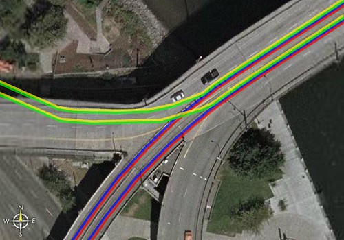
The current Red and Blue Lines meet up with the Yellow Line at rose quarter in a Y-shaped arrangement of track switches known as an Interlock:
A closer look reveals a conflict: In addition to the multiple automobile lanes of Interstate Avenue, Multnomah, and the Steel Bridge ramps, northbound Yellow Line trains must cross the path of opposite-direction Blue Line and Red Line trains. This means that one of those trains must wait before proceeding.
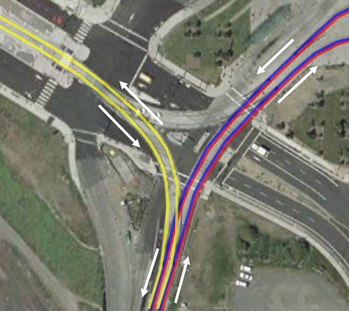
It should also be noted that although light rail is given signal priority, once the traffic signals have allowed automobile traffic to proceed, trains which have “just missed” their opportunity to request priority will have to wait for the automobile signal phase(s) to complete.
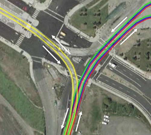
The Near Future
With the completion of the Green Line from Clackamas (est. 2009), which will utilize the existing Red/Blue line tracks through this area, there will be a high number of trains per hour operating through this crowded interlock.
Today’s Trains per Hour (peak):
| Line | Westbound/Southbound | Eastbound/Northbound | ||
| Blue Line | 8 | 8 | ||
| Red Line | 4 | 4 | ||
| Yellow Line | 4 | 4 | ||
| Totals | 16 | 16 | 32 |
2009 Opening-Day Trains per Hour (peak):
| Line | Westbound/Southbound | Eastbound/Northbound | |
| Blue Line | 8 | 8 | |
| Red Line | 4 | 4 | |
| Yellow Line | 4 | 4 | |
| Green Line | 4 | 4 | |
| Totals | 20 | 20 | 40 |
2025 Trains per Hour (projected peak):
| Line | Westbound/Southbound | Eastbound/Northbound | |
| Blue Line | 12 | 12 | |
| Red Line | 4 | 4 | |
| Yellow Line | 6 | 6 | |
| Green Line | 8 | 8 | |
| Totals | 30 | 30 | 60 |
Whenever a Northbound Yellow Line train enters the interlock, all Westbound/Southbound trains must wait. In 2025, there will be 6 times per hour when a potential conflict exists due to the Yellow Line. Every 10 minutes there will be an opportunity for a slight schedule hiccup to cause an actual delay.
There will be a Westbound/Southbound train coming every 2.5 minutes, pausing for 30 to 60 seconds at the Rose Quarter platform. If that train is delayed (by missing an opportunity to cross the interchange, or by a passenger holding the door, a pedestrian crossing against the light, or other everyday factors) even by one minute, the next train behind it is now delayed. This sets up a ripple effect. Because the interlock is operating at capacity, trains cannot be expedited through it to remove the ripple. All subsequent peak hour trains could become delayed, and additional factors could amplify that ripple.
Other Problems
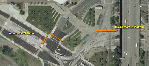
The Rose Quarter area has other problems than train interlock scheduling. Passengers wishing to transfer to the Yellow Line must walk over 300 feet and cross three separate, busy signalized crossings. These necessary pedestrian activities further constrain signal phase timing. After large events let out at the Rose Garden Arena or Memorial Coliseum, large crowds of people approach the platforms and jaywalking is an issue.
The current Red/Blue/Green platform area contains a third track used to store an extra train (usually eastbound) to provide immediate crowd relief to events. Any redesign of the transit facilities in this area must accommodate this important design feature.
Numerous groups and individuals have proposed further long-term enhancements to the transit system including a downtown subway, a new river crossing (bridge or tunnel), a Multnomah St. subway, and the modification of the system to accommodate 3-car trains (possible if a downtown subway is constructed.) A redesign should anticipate these plans so that further reconstruction in future decades is not required.
It is also vital that any redesign minimize interruption to the current system. Shutting down the Rose Quarter area for months to rebuild tracks would be highly disruptive to transit usage patterns in the region.
The existing interlock also provides an important connection for Yellow Line trains to travel to and from the maintenance facility in Gresham. This connection must be maintained for normal system operation.
Not directly addressed: New west-side interlock
A problem not addressed by this document: Once the Green Line is constructed, there will be a new interlock at the west end of the Steel Bridge. This interlock will create new constraints on capacity. These constrains can be partially (but only slightly) alleviated by the addition of a third track to the Steel Bridge. Because it is unknown to this author if the Steel Bridge could handle such modifications, that idea has been left out of this proposal.
Grade Separation
Grade Separation means giving a mode of transportation not just it’s own right of way (special lanes and signals, crossing gates) but to construct the route in such a way that conflicts are avoided in the first place (using bridges, ramps, tunnels, etc.)
If the most heavily traveled tracks (the Blue/Red/Green Lines) are grade separated, conflicts with auto traffic, opposite-direction rail traffic, and pedestrian traffic can be completely eliminated. This is the approach this proposal utilizes.
The Proposal
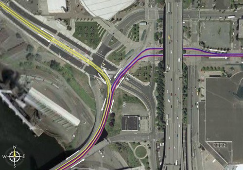
To create an underground “subway” station adjacent to the Rose Garden Arena, positioned under the arena lawn/plaza areas and Multnomah Street:
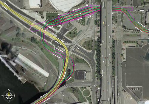
Purple lines indicate tunnel and station boundaries. Asterisks (*) indicate station entrances with “E” for elevators.
Design Aspects:
- A large, multi-platform station maintains the current extra-track arrangement
- The station and platforms are large enough to accommodate 3-car trains.
- Additional tunnel excavation at the east end allows for a future Multnomah St. subway.
- Further excavation at the west end allows for a future river crossing (bridge or tunnel) on the North side of the grain elevator facility.
Advantages:
- Conflicts with pedestrians, cars, and opposite-direction trains are completely eliminated.
- Various known future growth proposals are accommodated without further need for reconstruction.
- The station is located much closer to the major use in that area, the Rose Garden Arena.
- Crowds exiting Rose Quarter area events do not need to cross a street to reach Blue/Red/Green Lines.
- Transfers to the Yellow Line are now less than 100ft away and require crossing only one street with one direction of traffic.
- The middle track, in the years before 3-car operation begins, can accommodate (with care) two trains: A one-car Westbound train and a two-car Eastbound train, if desired.
- During construction, most excavation is away from existing rail lines, requiring minimal disruption to current rail operations.
- Station excavation can be done with less-expensive “Cut and Cover” methods, using Rose Garden Arena lawn areas as staging areas.
- Although automobile traffic on NE Multnomah (and the Steel Bridge on-ramp) will need to be closed for a long duration of time, it can be rerouted to nearby streets. Once construction is finished, automobile traffic will move much more smoothly through the area due to 80% fewer trains crossing against autos.
- Existing surface interlock tracks can remain in place to allow for Yellow Line start-of-day/end-of-day operations and as an emergency backup.
- Existing Blue/Red/Green platforms can remain for additional storage of up to 3 two-car trains to be deployed in any direction.
- Design uses almost entirely: Existing public right-of-way, private property containing no structures which can be restored to private use after completion, or private vacant land.
This plan is preliminary… Your comments and questions are appreciated.
42 responses to “How I would untangle the Rose Quarter”
sha-zam! That’s all I got to say. Sha-zam!
Torridjoe –
Thanks. :-)
Isaac –
Yes, I gave some thought to 3 cars vs. 4 cars. There would need to be survey of the existing system to see if extending platforms to 4 cars is practical in all areas.
I have done an informal look myself and I believe that the I-84 stops can be easily extended to 3 cars (with some track and signal work as well as electrical relocation) and there is probably room within Gateway to extend things to 3 cars but it would require significant track work.
Beyond Gateway, there is room in the ROW to extend the island stations along Burnside to 3 cars but roadway and trackway reconfiguration would be needed.
I think it may be too tight to hope to squeeze 4 car stations into the existing infrastructure. That’s why I am initially proposing a 3-car station. 3 cars gets you an immediate 50% capacity increase per train over what we have now.
– Bob R.
3 car or 4 car trains. I’ve seen 3 car operation of the LRV Cars used by the MAX System, but I’ve also read or heard that 3 is the suggested safe limit. Does anyone know the specifics on that?
As for the plan, I do like it, but think that it is a bit curvy – which would in and of itself slow the trains drastically. Just the curve leaving the station and heading the the bridge will drastically slow the trains, probably by an additional 15-30 seconds exiting/entering on the steel bridge side and 5-15 seconds on the exiting/entering side along Multnomah. I really like the idea but technically, being with how much work and effort and cost has already been sunk into the area would think that it would be better to just run some LRV Tracks down MLK or something and connect with a southern lying bridge (per say the one for the Milwaukee extension). The steal bridge is great, but it is itself a big slowdown in the travel to downtown.
Just my thoughts.
I’ve been thinking lately about possibly getting together with some people, printing out a decent size map, and sketching/marking/drawing out some of these ideas and even turning them into official proposals…
…would anyone be interested in such a idea?
adronhall at gmail dot com if it’s a valid interest.
Adron –
3/4 Car trains:
All of the specs I’ve found for the current Type I and Type II/III LRVs indicate that the cars are designed for consists of up to 4 cars.
The turning radii and trackwork banking of the current system may be a limiting factor, but if a new alignment is constructed for a subway, these needs may be addressable.
Personally I’m skeptical that there is room to accommodate 4 car trains, but I do believe that it is technically feasible. But 3 car trains seem to be generally easier to accommodate.
Curves:
The curves in my proposal are not the narrowest negotiated in the system, and should work at the speeds currently travelled by MAX on surface streets.
Any net increase in travel time due to the distance should be offset on average by the elimination of delays cause by waiting conflicting traffic (automobile, Yellow Line, and pedestrian.)
Curve severity and slope can be further reduced if a small medical office building is removed near the Convention Center, but I chose to limit the proposal in such a way that condemnation of structures would not be required.
Furthermore, most users of the new Rose Quarter station will find themselves much closer to their destination, whether it be the Rose Garden Arena (right at the doorstep), Memorial Coliseum (about 100ft closer), or transfers to the Yellow Line and buses.
Regarding effort/cost:
The point of this proposal isn’t just to alleviate an existing choke point. That alone might not be enough to justify the project. But what you get at the end is a facility which is ready for immediate expansion to projects which are likely to happen in the future – a new river crossing and a Multnomah St. subway.
If a Multnomah St. subway or surface alignment is built (Multnomah was the originally proposed alignment for MAX before it was shifted to Holladay), it will be a clean straight shot into the station, and the station will not require reconstruction. Same goes for a river crossing.
– Bob R.
“I’ve seen 3 car operation of the LRV Cars used by the MAX System”
…that statement I made doesn’t seem quit right.
What I was attempting to say, is I’ve seen the LRV Cars used here by the MAX System, used by other systems in 3 car configurations.
…just to clarify.
Bob,
On top of everything else, Rose Quarter has lots of bicycle commuters getting from N. Portland routes to the Esplanade, etc.
Seems like we are moving a lot of dirt for just 4, later 6, Yellow Line trains per hour. What about a flyover design for the Yellow Line, northbound, to straighten all this out. Leave the Red, Blue, Green as they are.
Do you know how the original South/North design dealt with this? As I recall the tracks tuned north on the east side of I-5, so the RQ platforms would have served Yellow as well as Blue and Red. But was the Wye still there?
The Plan from Bob Richardson has merit. I wish to add my comments to the scheme of planning. The Yellow line some day (soon I hope) will be extented to Clark County. I can see a possiblity of running 4 car consists from the Clark County Amphitheater to connect to the Yellow Line and turn East at Rose Quarter to Gateway and then go North along I-205 back to the Amphitheater. Bob’s plan would help with this possiblity.
By the way the Portland Bombardier LRV was designed to operate up to 5 car consists.
Trolley Dave Rowe
Thank you for addressing the Rose Quarter issue. Overall, it seems that it is just as much a bottleneck as the cross mall alignment is. It will not matter whether a new rail alignment uncongests Morrison/Yamhill if Rose Quarter or the Steel Bridge gets filled up. In fact, Yellow Line trains often get delayed today, WITHOUT the Green Line.
Very interesting.
I would like you to play out the same scenario but with a flyover for the Blue/Red/Green line. Seems like it would have many of the advantages plus unload people at the plaza level of the Rose Garden, avoiding road crossings (maybe keep on Multnomah?) and maybe be able to avoid some of the curve issues.
This would be quite a plus, making the Yellow connection easier for one thing.
This discussion makes me wonder about the Gateway area. Are we going to have the same problem, as pretty soon we will have three lines branching off from there?
Again to the 3 vs 4 car trains:
I agree that most of the stations on the MAX lines can’t handle 4 car trains, but as long as we’re talking about building one subway station for the future, we might as well think about the long term. In 30-40 years (or whenever) when we finally do have that fully-functioning subway system, it will no doubt be running at least 4-car trains, or we will want it to anyway. I think it would be a bad deal if we had to redo the Rose Quarter subway station because we didn’t think ahead, especially since so much thought is put into aligning the station for future expansion to begin with.
I’m also wondering what the effects of having subway stations will be on bikes the MAX. It’s a pain to drag your bike up and down long flights of stairs. I think it would be great if Portland could pave the way with bike-friendly subway stations.
Maybe it’s too early to talk about station design, but I’ll go ahead anyway. I’m temporarily living in Seoul, South Korea and although the subway system is fantastic, I’m always annoyed with how deep the stations are underground, sometimes six or more stories deep. It takes so long to get down there and transfers are LONG.
I recently visited Taipei, Taiwan and was amazed at the ease of use of their stations. I think their stations would be a good model for Portland, although their trains are much longer than 3 or 4 cars :) For starters, they are much closer to the surface, and when you descend the first flight of stairs to the ticketing area you can see the station platform and the trains coming and going. There’s no guesswork as to where the trains are, and it makes it seem like it’s that much closer to the street.
Here’s a picture that shows one of these stations.
http://static.flickr.com/13/15935320_09b977cca0.jpg
The photographer is standing on the mezzanine level, where the stairs from the street come down to.
Based on what I saw in the Netherlands and what others have reported from Japan, bikes on transit simply doesn’t scale very far. Instead you wind up providing LOTS of bike parking at stations and some folks have two bikes, one on either side of their rail commute.
So there I was at the Rose Quarter yesterday about 11:30am waiting for anything going Downtown, and the Bridge was up…way up…for some kind of maintenance/emergency repair. No trains, no buses. The Steel Bridge and its approaches clearly need more attention that Mall/Cross Mall issues.
As a regular MAX commuter, I’ve noticed the increasing signs of stress that the system is under. This will worsen of course once four lines (blue, red, yellow and green) start crossing the same bridge.
I would be curious to read comments on an alternate plan I’ve been pondering for quite some time. Instead of running the yellow line into downtown, how about an eastside alignment along the MLK/Grand couplet, thereby linking it with the future Milwaukie line to the south?
Of course this would require yellow line passengers commuting into downtown to transfer to one of the other lines. At least it would relieve some stress on the Steel Bridge and perhaps spur revitilization along the MLK/Grand couplet. Just a thought.
Wow, so many great responses. I’ll try to respond to each individually.
First, I want to talk more about train lengths. Isaac is arguing strongly that any reconstruction should accommodate the possibility of 4 car trains.
It can be somewhat confusing to discuss capacity in terms of the number of cars in a train, because car lengths vary widely from city to city.
A MAX Type II/III LRV is 92 feet long. A typical NYC subway car is 51 feet long. (A single MAX car can be viewed as two permanently-coupled, articulated small cars in that sense.) The Portland Streetcar vehicle is 66 feet long. San Francisco’s MUNI cars fall somewhere in between the Portland Streetcar and MAX in length.
I imagine that if 3 car or 4 car MAX service becomes common that a secondary “middle car” style of vehicle which has no cab ends (which waste space when unused) would be developed to further enhance capacity.
A more useful way to view future MAX capacity and compare to other cities is in the area of Platform Length. This helps to eliminate the number and type of vehicles from the discussion.
I light of Isaac’s remarks, I researched the platform lengths used in other cities.
Right now, MAX platforms are about 185ft. My proposal above was drawn with a platform length of 300ft to accommodate 3 car trains. But Isaac is right about other systems: Philadelphia’s short stations are 350ft, but Baltimore’s subway has 450ft platforms (enough to accommodate a 4 car MAX train with room to spare), New York City has a variety of lengths but has used approx. 615ft as a standard since the 1940’s. The Washington DC Metro uses 600ft, and BART comes in as the platform length leader with 700ft.
Thus, I intend to rework my proposal to allow for a minimum platform length of 400ft (4 car MAX trains with some breathing room for varying vehicle types.)
– Bob R.
Regarding bikes and station design.
I don’t want to get too far into station design ideas, but typical 3-track station would feature two island platforms, accessible by at least 2 elevators (1 for each platform) and 4 staircases (1 at each platform end.) A sufficiently deep station may also feature upward-bound escalators.
Bike users would be able to accommodate in the elevators. If the station is heavily used by bikes, it might prove useful to paint designated bike zones in the elevator cab and waiting area, with signage limiting trips to 2 bikes per elevator. (There is a capacity of 8 bikes per train, so this assumes that 25% of those users would be deboarding at this station. If more than 25% deboard, they would have to wait for the elevator to return.)
A mezzanine level connecting the platforms would likely be unnecessary. Because my proposal is for a station positioned under the Rose Garden Arena plaza, crossings could occur on the surface. As with the Washington Park station, ticket vending machines could also be located on the surface, removing platform clutter.
– Bob R.
Lenny Wrote: “What about a flyover design for the Yellow Line, northbound, to straighten all this out. Leave the Red, Blue, Green as they are.”
Although a Yellow Line flyover would be a less-expensive fix to a single problem, I do not believe it could be constructed without shutting down at least the Yellow Line during much of construction. It also puts more infrastructure in the way on the surface which could complicate future development of a new river crossing.
The reason I am pushing for the alignment shown here is to anticipate major future projects which I believe are necessary and inevitable, especially a new river crossing, and to do so in such a way that will require (hopefully) minimal interruption of existing rail service. (Although, admittedly, automobile commuters who rely on Multnomah St. and the Steel Bridge won’t be too happy about it during construction.)
– Bob R.
REVISED PROPOSAL
Okay, I’ve managed to squeeze a 400ft platform into the proposal without the station itself encroaching on I5 or Interstate Ave.
I’ve also made the east side curves quite a bit more gentle (this now assumes that the small medical/dental building near the convention center can be acquired and removed.)
On the west side, the westbound curve is also more gentle, utilizing the existing Steel bridge on-ramp. This change would require signalization to prevent automobiles and buses from going up the ramp when a train is approaching. Or, it might be possible to reconstruct the ramp in such a way that autos/buses “duck under” the a new westbound rail ramp.
Link:
Image of New Proposal
– Bob R.
John W. – there is an active effort to put Streetcar on MLK/Grand. At least one Metro Councilor has suggested we should make sure those tracks are LRT-capable. It would probably require a slightly deeper foundation (LRT is much heavier) but the trickiest problem is the platforms. Because of the difference in vehicle widths, you’d have to have some kind of platform that extended or retracted depending on the vehicle.
Chris wrote: (regarding MLK/Grand) “Because of the difference in vehicle widths, you’d have to have some kind of platform that extended or retracted depending on the vehicle.
“
It may be possible to design future Streetcar vehicles with “gap fillers”. The Breda cars used in the San Francisco MUNI subway feature short fillers that pop out between the car and the platform as the door opens.
– Bob R.
Chris says:
“Based on what I saw in the Netherlands and what others have reported from Japan, bikes on transit simply doesn’t scale very far.”
Would you like to clarify what you mean by bikes on transit don’t scale very far? I have seen in many cities the massive bike storage at subway stations and that’s great, but I was just wondering if Portland could, with that platinum rating in mind, lead the way in integrating bikes and subway stations. I realize that maybe we don’t want bikes on crowded subways, but we already have bikes on crowded light rail trains. What would be the difference?
I had a crazy idea. At Ikea they have special escalators for shopping carts next to the regular ones, what if we could get a special bike escalator?
Isaac:
It would be really cool if there were actually destinations to ride the Max to besides the city center. Living near downtown Portland, there really isn’t anyplace I would use the Max to go visit (downtown Hillsboro? Gresham? mrmmm.. na). And all the good biking is near downtown anyway, so its kind of a moot point.
Justin:
So because the MAX isn’t very good yet (opinion), we should just give up on making it better?
Isaac, my point about scaling was that if you make the bike/rail combination very popular, you very rapidly get to the point where you cannot possibly accomodate the demand to put the bikes on the vehicle, and you instead have to accomodate parking the bikes.
We see this already with “bikes on buses” on popular TriMet routes during the AM/PM peak.
Justin wrote: “It would be really cool if there were actually destinations to ride the Max to besides the city center.”
Well, at various times I have utilized MAX to go to destinations as diverse as: Office Depot (Downtown and Gateway), Fred Meyer (Gateway), Bed Bath and Beyond (Gresham station), the Expo Center, the Convention Center (although I have issues with the need for that station), the Oregon Zoo, the Esplanade (taking my bike with me), Kitchen Kaboodle (Orenco Station), and more.
Furthermore, MAX connects with many north-south bus lines at Hollywood, 60th, 82nd, Gateway, and 122nd. MAX serves as a “spine” in this case.
Transit in the metro area should be viewed as a “system” of multiple modes – Bus, MAX, Streetcar. MAX enhances the connectivity of the overall system.
– Bob R.
Bob:
Won’t the station depth be different depending on whether they decide to go with a new bridge or a tunnel under the river? If yes, then the crossing would have to be decided and good preliminary engineering done before we could go ahead with the proposed subway station. Would that hold back construction significantly?
Isaac –
I need a good topographical map of the area, but an informal walk-through shows that there is quite a bit of slope there to potentially split the difference.
But, my point in doing all this is to provoke discussion and hopefully also alert officials to the fact that we need to be master-planning this area now, so that key parcels are not lost to development that is not compatible with inevitable future needs.
– Bob R.
If a new LRT bridge was built across the Willamette north of the Steel Bridge, I would think that an open trench could be built along Holladay (or Multnomah) instead of a subway through the Lloyd & Rose Quarter which would reduce costs. But I think the issue with this would be how a bridge would transition into a subway tunnel on the west side by Union Station.
This is a really interesting discussion. I moved to Portland in June 2006, so I missed it originally. Please excuse a few comments, late as they are — with the current Streetcar discussions, I think these are still pertinent.
The discussion of 3- or 4-car MAX trains is interesting, but I don’t think it’s possible to run those downtown, either on the Morrison/Yamhill alignment or on the 5th/6th one. A 2-car train comes very close to filling a 200-foot downtown block, so a longer train wouldn’t be able to stop without encroaching on cross traffic. I understand that a 2-car train of the new S70s will be even longer, just under 200 feet.
In reading everything I could lay my hands on during this year here, I’ve become concerned that the Streetcar planning and the MAX planning have gotten out of sync with each other. We have a new MAX line coming on the Mall that’s really better suited to a downtown-circulator mode, and we’re talking about new streetcar lines (especially to Lake O) that may be better suited to long-haul light rail. It makes me wonder who’s looking at the big picture? Are we so focused on what’s politically possible that we’re not working on a Grand Scheme?
Once the Mall and the Green Line open in 2009, we’ll see from experience whether or not the congestion around and in the Steel Bridge, and at the Rose Quarter junction, is bearable. My guess is that it’ll be pretty bad, especially if a train is delayed or breaks down at the wrong place (say, at one of those flat junctions).
I think it’s time to start thinking about the long-term solution, which I think is a Willamette tunnel and a downtown east-west subway. Beginning somewhere around the Rose Quarter, ducking under the river, then joining the current MAX tracks somewhere near PGE Park. The tunnel could even run diagonally under the city, with a few strategically placed stations.
This would solve the Rose Quarter and Steel Bridge problems, and allow 3- or 4-car trains because it wouldn’t be constrained by 200-foot blocks. I don’t know enough about Portland’s water table to know how deep the tunnel would have to be, but on the other hand I can look down into those multilevel underground garages under construction and they seem to be dry. So it might work.
The existing downtown MAX alignments could provide “local” service using streetcars, along with the existing streetcar alignments. We know the streetcars can run under MAX wires and on MAX rails; there are already some switches going between the systems.
The result would be something like San Francisco’s 3 levels on and under Market Street, or even Seattle’s forthcoming light rail, which will finally get some productivity out of that monumental downtown tunnel built nearly 20 years ago.
Would the public go for it? Well, maybe. MAX has been here since 1986, and is carrying a record 110,000 riders/day; the Streetcar was carrying about 10,000 even before the new extension opened last Friday.
So modern rail transit is not new anymore, something revolutionary to “sell” to the public. People don’t have to imagine it, they can see it and ride it, so they can put their imagination to work on the next generation of transit. Portland was a light-rail pioneer back in 1986, but now there are lots of other new light-rail cities in the US to look at for examples.
Anyone who’s visited San Francisco or Cleveland or Boston or Philly (and soon, Seattle)– not to mention any number of Western European cities — might well know about light rail subways. Maybe the public will buy the notion that dividing the Portland rail infrastructure better between local and long-haul express transit (remember the X in MAX?) is a way to make both modes better. It’ll cost a lot of money, sure, but might be worth it in the grand scheme of things.
Mike
Mike, there are in fact several efforts to produce a comprehensive rail plan. Commissioner Adams has kicked off a City-wide rail plan for Portland, which will dovetail with a regional equivalent that Metro is coordinating.
With respect to the Willamette Shoreline project, Metro has previously evaluated that corridor for LRT and concluded that the available right-of-way is too narrow for LRT operations (it’s just barely wide enough for single-track Streetcar in some places).
Metro also did some initial analysis on extending the proposed Milwaukie line down the east side of the river and crossing near or on the rail bridge to serve LO and concluded that it served a different ridership profile (at greater cost) than the Streetcar effort.
My wife and I rode the Willamette Shoreline car some years ago, when it still terminated at River Place. I saw the new terminus not long ago, but don’t recall exactly how far it is from the Streetcar terminus. How much rail was pulled up?
So I find myself wondering about the possibility of an inexpensive experiment.
Extend the track back up to South Waterfront so it ends just next to the new Streetcar terminus, then run the heritage cars on a regular enough schedule so commuters could actually use them. Then see who shows up at the various intermediate stops.
The cars and (most of) the infrastructure exist already, powered by those funny trailers that generate the electricity. Could the experiment be staffed by the same group of volunteers? A lot of them showed up at the Streetcar opening last week…
I’ve read in the recent press stories that the whole Lake O issue is fraught with NIMBY problems. Maybe they are fatal, but maybe not.
* * * * *
Does Sam’s plan (or anyone’s) give serious consideration to making better use of the river? Given the success of the water taxi in numerous other cities, I was surprised at not seeing it here. Downtown-to-OMSI is one obvious application — it would be very attractive to visitors, and maybe even to commuters. Especially if the boats allowed bicycles.:-)
I wonder how much a dock would cost over at OMSI? Or maybe there is one already — I dunno. On the downtown side, the tour boat dock might be usable.
Mike
The new Lowell extension terminates one block north of Brancroft, where the Trolley terminus is. We did not go that last block because (among other things) PDOT has not figured out how they’re going to rebuild that section of Moody as part of the south portal from Macadam into South Waterfront (i.e., we don’t know how the street with be graded).
Peter Wilcox continues to work hard on promoting river transit. Some of his ideas are very interesting, but he has yet to find much reception among leaders.
River transit from LO to Portland has been analyzed and ruled out several times, mainly due to the lack of suitable landings in LO that are near housing or employment centers, or with sufficient space for parking.
The new Lowell extension terminates one block north of Bancroft, where the Trolley terminus is.
In other words, one could walk just a block from the Trolley to/from the Streetcar. So near and yet so far.:-)
I think I have the latest Trolley timetable — it doesn’t seem to run enough weeks, or at the right hours, to even think about it as a commuter thing. Only a tourist or a diehard railfan would take it. Has there been any discussion of an experiment like my suggestion?
River transit from LO to Portland has been analyzed and ruled out several times, mainly due to the lack of suitable landings in LO that are near housing or employment centers, or with sufficient space for parking.
OK, I see the LO issue. But how ’bout from the East Side? My impression is that there’s reasonable parking in the OMSI area and bicyclists would (I surmise) love it. A simple and (maybe) inexpensive experiment to test the interest?
New York has seen a spectacular revival of cross-Hudson ferries. The routes and ridership just seem to keep growing. Of course, Portland traffic is in a whole different league from NY’s.
Mike –
Regarding train lengths, a full downtown subway would not be required to run 3 or 4 car trains.
I forget who first pointed this out on Portland Transport — it was discussed fairly recently (please chime in to claim credit!) — but with careful tunneling along Morrison and/or Yamhill, you’d only need to do about 10 blocks of tunnel.
The idea only affects the Red/Blue lines, but these are currently the lines subject to the most crowding and will be hitting their peak capacity before the other lines.
The idea (with some refinements inserted by me) goes something like this:
(Assume that most freeway and median stations east and west of downtown can be elongated — the Zoo would be the most troublesome/expensive, but straightforward.)
1. Lloyd Center – This is already a double-length block and can accommodate 4-car trains.
2. Shift the 7th Ave. station westward. 6th is already closed to North-South traffic at Holladay today, so there is room here for a 4-car station between Grand and 7th.
3. Eliminate the Convention Center station (Don’t panic – convention center users!) Extend the walkway from the convention center to the Rose Quarter by extending the existing glass canopy. The walk can be the same as today or up to 100ft further depending on which of the north-side convention center entrances is used.
4. Either implement the underground Rose Quarter proposal from the top of this discussion, *OR* elevate the 1st avenue ramp off of I-5 to cross Holladay and land at Multnomah, *OR* force 1st and the ramp to make right turns only onto Holladay. This then gives room for 400ft trains at Rose Quarter, which will now be called the “Rose Quarter / Convention Center” station.
So far so good, lots of room for 4-car trains on the east side, and we’ve eliminated a stop, thus saving time.
5. Eliminate the Old Town / Chinatown stop. Old Town will soon be served well by the Yellow and Green Line trains. (And those who really need to access the area between 3rd and the Waterfront centered on Davis will only have 1 or 2 blocks further to walk, see below…)
6. There is already room for 4-car platforms at the Skidmore Fountain station, centered on Burnside from Couch to Ankeny, although some regrading of sidewalks will be required.
7. Close either Oak or Pine to through traffic at 1st Ave. (depending on which of the two has lower traffic volume) — there is now room for 4-car trains at 1st. and Oak. Convert the other of the Oak/Pine streets to two-way traffic between Naito and 2nd to allow for auto access.
8. As MAX ducks down low to go under the Morrison Bridge, simply keep heading downward into a new tunnel. This might be a pair of tunnels under Morrison/Yamhill like today, or just one big tunnel, or perhaps could utilize Taylor to minimize construction impacts.
9. Have two stations serving the core of downtown instead of the current 3. One from about 1st to 3rd and another catching Pioneer Place and the mall and the corner of Pioneer Courthouse Square from 4th to 6th.
10. Have a third station centered near the Galleria, from 9th to 11th, which will connect quite will with the current streetcar on 10th/11th.
11. Emerge to street level in order to cross I-405.
12. Enlarge the center platform of the now underused Kings Hill / Salmon station 1 block to the north. This will now be 1 big combined PGE Park / Kings Hill station. (This may require sidewalk narrowing on the west side of 18th, but there is a lot of room to work with there.)
13. Either find a way to close 20th at Goose Hollow, or squeeze the Goose Hollow platforms into the space west of 20th.
There… with those 13 lucky steps, you have the capability of doubling capacity while actually improving trip times (by eliminating/consolidating 1 station on the east side and 3 stations on the west side.)
All of this would cost a lot, but would not need to be nearly as extensive of a project as most people think of when they hear the term “subway”.
– Bob R.
The Trolley is definitely a tourist deal. I have not heard any proposal to try to run commuter service on the existing tracks or with the existing fleet.
The Peter Wilcox river transit proposal is very much about the Portland stretch of the river, but so far no traction.
The Trolley is definitely a tourist deal. I have not heard any proposal to try to run commuter service on the existing tracks or with the existing fleet.
I think you mean “have not heard any proposal” meaning a formal proposal or murmurs within local government, right? I believe Erik and Adron proposed something like this here on PortlandTransport a week or two ago.
I would be curious to know the maximum safe operational speed that can be supported by the current tracks and trackside improvements… if trolleys have to operate at the current speed they do today (even with more powerful generators), the usefulness of the line beyond tourist curiosity would be very limited.
The current one-way trip is 40 minutes and you’re just getting from Lake Oswego to Lowell.
– Bob R.
I forget who first pointed this out on Portland Transport — it was discussed fairly recently (please chime in to claim credit!) — but with careful tunneling along Morrison and/or Yamhill, you’d only need to do about 10 blocks of tunnel.
That was me. And what I had in mind for east/west MAX service was similar to your proposal, with a few changes:
(1) Eliminate the Lloyd Center station (which really serves Holladay Park) and build a 400 foot platform between 7th and 9th Avenues. It’s about the same distance from MAX to the Mall along 9th as along 11th.
(2) Eliminate the Convention Center station (this creates a challenge for MAX/#6 transfers) and reroute traffic on NE First Avenue (east on Holladay, north on 2nd) to allow a 400 foot station at Rose Quarter/Convention Center station.
(3) Four tracks on the Steel Bridge, two of which (the outside lanes) share lanes with cars. No grade separation needed. I’ll skip the detailed explanation of how I see it working: the simple version is that there are two pairs of westbound/eastbound tracks, north and south, with the current tracks reversed (hence, banning cars from the center of the bridge). The northern pair of tracks handles Green/Yellow; the southern pair handles Red/Blue. Green line trains are the only trains that will ever need to wait for another train to clear track, and that will occur (both directions) in the Rose Quarter.
(4) On NW/SW First Avenue, eliminate Old Town/Chinatown and Oak Street stations. Regrade the sidewalks to allow 400 foot platforms at Skidmore Fountain.
At this point, four stations are gone, and that significantly speeds up operations in the core. It leaves just three stops between Hollywood TC and the tunnel.
(5) Put the tunnel under Morrison Street from 1st Avenue (continuing downward under the Morrison Bridge) to 12th. Two stations:
(a) The first station covers 4th and 5th Avenues, with ramped access at the south end to come up just south of 3rd, and a ramp at the north end that comes out north of sixth. This station essentially folds together three existing MAX stations, and connects to the transit mall at the northern end.
(b) The second station covers 10th and 11th avenues, for connection to the Portland Streetcar.
(6) Then come to the surface on Morrison between 12th and 13th to cross I-405. Two tracks on Morrison (which would look a lot like 1st Avenue) to the (already double-tracked) PGE park station.
(7) Extend King’s Hill station one block north, as Bob suggested.
Thus, even if we keep the Goose Hollow station (which, as Bob noted, would need to be expanded), this cuts the total number of stops between Washington Park and Hollywood from 14 to 7, and allows 400 foot trains all the way through the core. Quadruple-tracking the Steel Bridge should eliminate most of the conflicts.
As Bob pointed out, this would be relatively inexpensive to build as subway proposals go. Twelve blocks under one street, built with the standard “cut and cover” excavation process (no tunnelling needed), and simple, shallow one-level subway platforms (no expensive mezzanine level).
(I’d then put a second track on Yamhill and use it for streetcars between Northwest Portland and the Hawthorne Bridge)
Since this thread has now been given a new life, I might as well stick in my two cents.
Reading all these posts, I am amazed by all of the logistical problems encountered with this rail operation here. I cringe when I think of the fact that the orginal transit proposal back in the 1970’s was a non-stop busway on the Banfield between Lloyd Center and Gateway. Thanks to the efforts of Mr. Howell and various others, it was changed to LRT, with stations. Now we have to suffer the consequences of a poorly designed and operated LRT system, with Mr. Howell vocally complaining about the new transit mall on 5th and 6th Avenues. Well, it’s poetic justice time for Mr. Howell and others. Remember, “You reap what you sow.”
The tragedy here is that the BRT implementation would have been the most elegant solution for Portland, given its spatial and density characteristics. Instead, we are stuck with this dysfuctional spaghetti mess of rails by the Steel Bridge, which is only going to get worse and worse (think rebuilt transit mall in 2009).
The more I read in these discussions, the more I realize that we would have been much better off today if we had gone the bus/BRT route.
Now maybe some of you realize why I have been so vocal about transit here in Portland.
Sorry, Nick, I don’t see it the way you do at all. Those same BRT buses would be stopping at the same traffic lights and waiting for the same proceed signals as MAX, only instead of one big train operating on a 6 minute headway at peak hour you’d need 4 to 5 standard buses (or 3 to 4 articulated buses) operating at about 1.3 minute headways, becoming hopelessly bunched up and delayed and costing much more to operate.
MAX is pretty full at peak well past Gateway… if those BRT buses diverged prior to that, the capacity needs would not be met, and if they didn’t, you’d have MAX on rubber tires but with degraded service.
Count me out of your revisionist fantasy.
– Bob R.
And one more thing about this thread, Nick… What we are discussing here is a system that has served us well the past 20 years, and will serve us well the next 10… the question is what to do after that to allow that system to grow to meet our needs for 30 or more years after that — through a series of incremental, seldom dramatic improvements.
– Bob R.
4 tracks on the steel bridge, (as every other direction on each lane,) would be a great idea, and if you make it so that the trains never has to cross over an opposing direction track, (so Bob’s idea would work for the eastbound Green line, but you’d need a slightly different arrangement for the westbound Green line,) the traffic limit would literally consist of how close together could you get the trains in the same direction: At 5 mph, you can run 60+ trains an hour per bridge track if they are 200 feet apart… At 60 trains a hour, station dwell time starts to become a real issue, not the bridge… (And 60 trains/hour on 4 tracks, even if they are all two car trains is just under 100,000 people/hour… How many people want to go in or out of downtown per hour anyways? And wouldn’t some of them be going/coming from the south or west?)
But my main point: By 2025, the Yellow line should have made it to Vancouver, and it is 5 trains per peak hour now. Yes, those trains will be two car, (although I haven’t seen a single car Yellow since the May ridership numbers came out… I’ve seen a few Red single cars though… But that is a different question.) You only expect 6 trains per peak hour in 2025? If N Portland keeps it up, it will fill those up by themselves, and if a bunch of people from Vancouver are riding as well, we’d be talking 8 or 10 trains per peak hour…
Nick, please don’t blame me for TriMet’s recent misapplication of the light rail mode.
Light rail should be the region’s rapid transit system linked to frequent local and cross-town bus service at convenient and safe transfer stations which would provide direct, fast access to multiple regional destinations at all times.
By putting light rail on the mall, TriMet is using it as a streetcar operation, not rapid transit. Light rail that must operate with pedestrians, bicycles, cars, trucks and buses must run slowly, which makes through trips far too time consuming for most commuters to tolerate.
The original decision to run light rail in mixed traffic in the Lloyd District and downtown was justified as a pragmatic way to kick-start the system. Nevertheless, with the westside extension, it became apparent that the slow operation through town has discouraged its use for interregional trips.
Why then is TriMet and Metro planning to make the same mistake on the regions north-south light rail system by diverting the Milwaukie Light Rail Line across the river, through downtown, and then back across the river to then continue north to Vancouver?
This circuitous routing forfeits the opportunity to provide commuters, now overloading McLoughlin, MLK/Grand and I-5 north with peak hour traffic, a compelling reason to switch to public transit.
Downtown is not the center of the universe. It attracts only a small fraction of the regional trips and in spite of the downtown orientation of the transit system most transit trips now taken in the Mcloughlin corridor don’t end up downtown.